 |
|
|
|
|
|
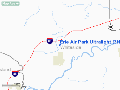
Location
& QuickFacts
|
FAA
Information Effective: |
2007-12-20 |
|
Airport
Identifier: |
3H5 |
|
Airport
Status: |
Operational |
|
Longitude/Latitude: |
090-04-43.0000W/41-40-56.7000N
-90.078611/41.682417 (Estimated) |
|
Elevation: |
600 ft / 182.88 m (Estimated) |
|
Land: |
26 acres |
|
From
nearest city: |
1 nautical miles N of Erie, IL |
|
Location: |
Whiteside County, IL |
|
Magnetic
Variation: |
01E (1985) |
Owner
& Manager
|
Ownership: |
Privately
owned |
|
Owner: |
James E. Robinson |
|
Address: |
8689 Star Rd
Erie, IL 61250 |
|
Phone
number: |
309-659-2721 |
|
Manager: |
James E Robinson |
|
Address: |
8689 Star Rd
Erie, IL 61250 |
|
Phone
number: |
309-659-2721 |
Airport
Operations and Facilities
|
Airport
Use: |
Open
to public |
|
Wind
indicator: |
Yes |
|
Segmented Circle: |
No |
|
Control
Tower: |
No |
|
Landing
fee charge: |
No |
|
Sectional chart: |
Chicago |
|
Region: |
AGL - Great Lakes |
|
Traffic
Pattern Alt: |
800 ft |
|
Boundary
ARTCC: |
ZAU - Chicago |
|
Tie-in
FSS: |
IKK - Kankakee |
|
FSS
on Airport: |
No |
|
FSS
Toll Free: |
1-800-WX-BRIEF |
|
NOTAMs
Facility: |
IKK (NOTAM-d service avaliable) |
Airport
Communications
Airport
Services
|
Airframe
Repair: |
NONE |
|
Power
Plant Repair: |
NONE |
|
Runway Information
Runway 18U/36U
|
Dimension: |
2000
x 200 ft / 609.6 x 61.0 m |
|
Surface: |
TURF, Good Condition |
|
|
Runway 18U |
Runway 36U |
|
Longitude: |
090-04-43.0300W |
090-04-42.9400W |
|
Latitude: |
41-41-06.6200N |
41-40-46.8600N |
|
Traffic
Pattern: |
Left |
Left |
|
Obstruction: |
42 ft tree, 750.0 ft from runway, 100 ft left
of centerline, 18:1 slope to clear |
39 ft trees, 900.0 ft from runway, 100 ft right
of centerline, 23:1 slope to clear |
|
Radio Navigation
Aids
|
ID |
Type |
Name |
Ch |
Freq |
Var |
Dist |
|
BOZ |
NDB |
Whiteside |
|
254.00 |
01E |
13.3 nm |
|
CWI |
NDB |
Clinton |
|
377.00 |
01E |
14.2 nm |
|
EZI |
NDB |
Kewanee |
|
245.00 |
01E |
29.4 nm |
|
OQW |
NDB |
Maquoketa |
|
386.00 |
02E |
37.0 nm |
|
FEP |
NDB |
Freeport |
|
335.00 |
00E |
40.4 nm |
|
VYS |
NDB |
Valley |
|
230.00 |
00W |
46.3 nm |
|
PLL |
VOR/DME |
Polo |
049X |
111.20 |
03E |
30.1 nm |
|
GBG |
VOR/DME |
Galesburg |
035X |
109.80 |
03E |
47.6 nm |
|
CVA |
VORTAC |
Davenport |
085X |
113.80 |
04E |
18.2 nm |
|
MZV |
VORTAC |
Moline |
091X |
114.40 |
05E |
33.3 nm |
|
BDF |
VORTAC |
Bradford |
094X |
114.70 |
00E |
38.4 nm |
|
DVN |
VOT |
Davenport Municipal |
|
111.80 |
|
23.2 nm |
Based Aircraft
|
Aircraft
based on field: |
23 |
|
Single
Engine Airplanes: |
17 |
|
Ultralights: |
6 |
Operational Statistics
Time Period: 2005-01-01 - 2005-12-31
|
Aircraft
Operations: |
116/Week |
|
General
Aviation Local: |
83.3% |
|
General
Aviation Itinerant: |
16.7% |
Erie Air Park Ultralight
Address:
Whiteside County, IL
Tel:
309-659-2721
Images
and information placed above are from
http://www.airport-data.com/airport/3H5/
We
thank them for the data!
| General
Info |
| Country |
United
States |
| State |
ILLINOIS
|
| FAA ID |
3H5 |
| Latitude |
41-40-45.111N
|
| Longitude |
090-04-43.431W
|
| Elevation |
600 feet
|
| Near City |
ERIE |
We don't guarantee the information is fresh and accurate. The data may
be wrong or outdated.
For more up-to-date information please refer to other sources.
|
|


