|
|
|
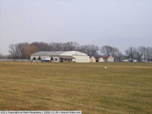 |
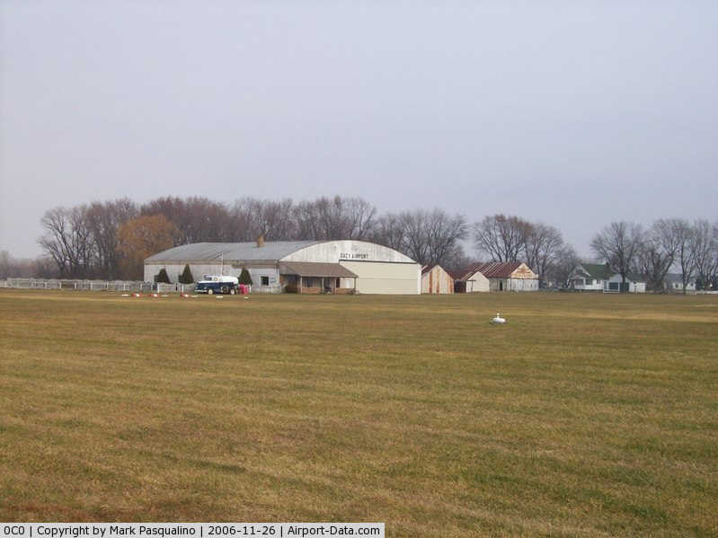
(Click on the photo to enlarge) |
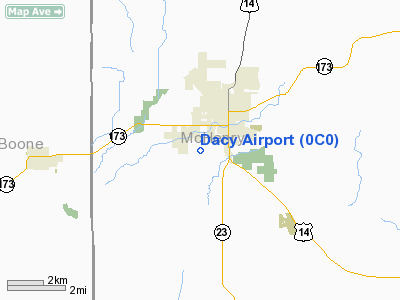
Location
& QuickFacts
|
FAA
Information Effective: |
2007-07-05 |
|
Airport
Identifier: |
0C0 |
|
Airport
Status: |
Operational |
|
Longitude/Latitude: |
088-37-56.6000W/42-24-08.9000N
-88.632389/42.402472 (Estimated) |
|
Elevation: |
913 ft / 278.28 m (Surveyed) |
|
Land: |
100 acres |
|
From
nearest city: |
1 nautical miles SW of Harvard, IL |
|
Location: |
Mc Henry County, IL |
|
Magnetic Variation: |
00W (1985) |
Owner & Manager
|
Ownership: |
Privately owned |
|
Owner: |
John F. Dacy |
|
Address: |
22207 Airport Rd
Harvard, IL 60033 |
|
Phone number: |
815-943-9876 |
|
Manager: |
Dave Dacy |
|
Address: |
22207 Airport Rd
Harvard, IL 60033 |
|
Phone number: |
815-943-9876 |
Airport
Operations and Facilities
|
Airport
Use: |
Open
to public |
|
Wind
indicator: |
Yes |
|
Segmented Circle: |
No |
|
Control
Tower: |
No |
|
Lighting
Schedule: |
SS-SR |
|
Landing
fee charge: |
No |
|
Sectional chart: |
Chicago |
|
Region: |
AGL - Great Lakes |
|
Traffic
Pattern Alt: |
600 ft |
|
Boundary
ARTCC: |
ZAU - Chicago |
|
Tie-in
FSS: |
IKK - Kankakee |
|
FSS
on Airport: |
No |
|
FSS
Toll Free: |
1-800-WX-BRIEF |
|
NOTAMs
Facility: |
IKK (NOTAM-d service avaliable) |
|
Federal Agreements: |
N |
Airport Communications
Airport
Services
|
Fuel
available: |
100LL |
|
Airframe
Repair: |
MAJOR |
|
Power
Plant Repair: |
MAJOR |
|
Bottled
Oxygen: |
NONE |
|
Bulk
Oxygen: |
NONE |
|
Runway Information
Runway 09/27
|
Dimension: |
3589
x 105 ft / 1093.9 x 32.0 m |
|
Surface: |
TURF, Good Condition |
|
|
Runway 09 |
Runway 27 |
|
Longitude: |
088-38-28.3192W |
088-37-40.4829W |
|
Latitude: |
42-24-01.6899N |
42-24-01.8576N |
|
Elevation: |
899.00 ft |
913.00 ft |
|
Alignment: |
90 |
127 |
|
Traffic
Pattern: |
Left |
Left |
|
Markings: |
None,
DSPLCD THLD MKD WITH WHITE TIRES. |
None, |
|
Displaced
threshold: |
300.00 ft |
0.00 ft |
|
Runway
End Identifier: |
No |
No |
|
Centerline
Lights: |
No |
No |
|
Touchdown
Lights: |
No |
No |
|
Obstruction: |
20 ft tree, 95.0 ft from runway, 107 ft right
of centerline, 4:1 slope to clear
APCH RATIO 20:1 TO DSPLCD THLD. |
55 ft tree, 1318.0 ft from runway, 102 ft left
of centerline, 23:1 slope to clear |
|
Runway 14/32
|
Dimension: |
2633
x 100 ft / 802.5 x 30.5 m |
|
Surface: |
TURF, Good Condition |
|
|
Runway 14 |
Runway 32 |
|
Longitude: |
088-37-56.6257W |
088-37-41.6261W |
|
Latitude: |
42-24-25.8625N |
42-24-02.3497N |
|
Elevation: |
912.00 ft |
912.00 ft |
|
Alignment: |
127 |
127 |
|
Traffic
Pattern: |
Left |
Left |
|
Markings: |
None,
DSPLCD THLD MKD WITH WHITE TIRES. |
None, |
|
Displaced
threshold: |
681.00 ft |
0.00 ft |
|
Runway
End Identifier: |
No |
No |
|
Centerline
Lights: |
No |
No |
|
Touchdown
Lights: |
No |
No |
|
Obstruction: |
37 ft tree, 263.0 ft from runway, 173 ft right
of centerline, 7:1 slope to clear
SLOPE 20:1 TO DSPLCD THLD. |
, 0.0 ft from runway, 50:1 slope to clear |
|
Runway 18/36
|
Dimension: |
2577
x 120 ft / 785.5 x 36.6 m |
|
Surface: |
TURF, Good Condition |
|
Edge
Lights: |
Non-standard lighting system
NSTD LIRL; NSTD SPACING & NON-FRANGIBLE. |
|
|
Runway 18 |
Runway 36 |
|
Longitude: |
088-37-53.3505W |
088-37-53.3369W |
|
Latitude: |
42-24-26.3140N |
42-24-00.8556N |
|
Elevation: |
913.00 ft |
909.00 ft |
|
Alignment: |
127 |
127 |
|
Traffic
Pattern: |
Left |
Left |
|
Markings: |
None,
DSPLCD THLD MKD WITH WHITE TIRES. |
None, |
|
Displaced
threshold: |
305.00 ft |
0.00 ft |
|
Runway
End Identifier: |
No |
No |
|
Centerline
Lights: |
No |
No |
|
Touchdown
Lights: |
No |
No |
|
Obstruction: |
15 ft road, 30.0 ft from runway, 2:1 slope
to clear
APCH RATIO 22:1 TO DSPLCD THLD. |
, 50:1 slope to clear |
|
Radio Navigation
Aids
|
ID |
Type |
Name |
Ch |
Freq |
Var |
Dist |
|
LVV |
NDB |
Lake Lawn |
|
404.00 |
00W |
17.9 nm |
|
JVL |
NDB |
Janesville |
|
375.00 |
03E |
22.2 nm |
|
DKB |
NDB |
Dekalb |
|
209.00 |
02W |
28.4 nm |
|
RA |
NDB |
Paser |
|
206.00 |
00E |
36.6 nm |
|
ME |
NDB |
Deana |
|
350.00 |
00E |
37.6 nm |
|
GM |
NDB |
Teels |
|
242.00 |
02W |
40.1 nm |
|
UES |
NDB |
Waukesha |
|
359.00 |
01W |
42.4 nm |
|
FEP |
NDB |
Freeport |
|
335.00 |
00E |
43.4 nm |
|
RYV |
NDB |
Rock River |
|
371.00 |
01W |
46.5 nm |
|
BUU |
VOR/DME |
Burbun |
092X |
114.50 |
01W |
22.6 nm |
|
JVL |
VOR/DME |
Janesville |
090X |
114.30 |
03E |
23.0 nm |
|
RFD |
VOR/DME |
Rockford |
045X |
110.80 |
01E |
27.3 nm |
|
OBK |
VOR/DME |
Northbrook |
077X |
113.00 |
02W |
32.1 nm |
|
ENW |
VOR/DME |
Kenosha |
029X |
109.20 |
02W |
33.2 nm |
|
DPA |
VOR/DME |
Dupage |
021X |
108.40 |
02E |
33.3 nm |
|
ORD |
VOR/DME |
Chicago O'hare |
086X |
113.90 |
02E |
40.9 nm |
|
HRK |
VOR/DME |
Horlick |
124X |
117.70 |
02W |
42.2 nm |
|
PLL |
VOR/DME |
Polo |
049X |
111.20 |
03E |
47.6 nm |
|
LJT |
VOR/DME |
Timmerman |
072X |
112.50 |
02W |
50.0 nm |
|
BAE |
VORTAC |
Badger |
111X |
116.40 |
02E |
45.6 nm |
|
ORD |
VOT |
Chicago O'hare Intl |
|
112.00 |
|
41.0 nm |
|
MKE |
VOT |
Milwaukee |
|
109.00 |
|
46.2 nm |
Remarks
Based
Aircraft
|
Aircraft
based on field: |
60 |
|
Single
Engine Airplanes: |
60 |
Operational Statistics
Time Period: 2004-01-02
- 2004-12-31
|
Aircraft
Operations: |
55/Day |
|
General
Aviation Local: |
50.0% |
|
General
Aviation Itinerant: |
50.0% |
Dacy Airport
Address:
Mc Henry County, IL
Tel:
815-943-9876
Images
and information placed above are from
http://www.airport-data.com/airport/0C0/
We
thank them for the data!
| General
Info |
| Country |
United
States |
| State |
ILLINOIS
|
| FAA ID |
0C0 |
| Latitude |
42-24-08.900N
|
| Longitude |
088-37-56.600W
|
| Elevation |
913 feet
|
| Near City |
HARVARD
|
We don't guarantee the information is fresh and accurate. The data may
be wrong or outdated.
For more up-to-date information please refer to other sources.
|
|