 |
|
|
|
|
|
Location
& QuickFacts
|
FAA
Information Effective: |
2007-07-05 |
|
Airport
Identifier: |
35IL |
|
Airport
Status: |
Operational |
|
Longitude/Latitude: |
089-12-10.0000W/41-32-02.0000N
-89.202778/41.533889 (Estimated) |
|
Elevation: |
800 ft / 243.84 m (Estimated) |
|
Land: |
0 acres |
|
From
nearest city: |
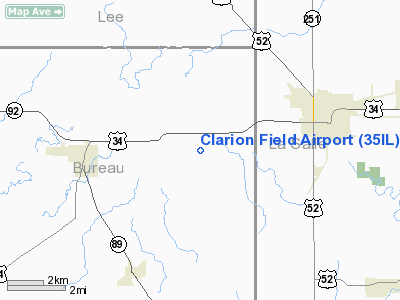
3 nautical miles E of La Moille, IL |
|
Location: |
Bureau County, IL |
|
Magnetic Variation: |
01W (1995) |
Owner
& Manager
|
Ownership: |
Privately
owned |
|
Owner: |
Mel Forrester
OTHER OWNERS BILL BENTLEY; 112 11TH STREET; MENDOTA IL 61342;
AND GENE ARNOLD 911 MERIDEN; MENDOTA IL 61342. |
|
Address: |
912 13th Avenue
Mendota, IL 61342 |
|
Phone number: |
815-539-5378 |
|
Manager: |
Melvin D Forrester |
|
Address: |
912 13th Avenue
Mendota, IL 61342 |
|
Phone number: |
815-539-5378 |
Airport
Operations and Facilities
|
Airport
Use: |
Private |
|
Wind
indicator: |
Yes |
|
Segmented Circle: |
No |
|
Control
Tower: |
No |
|
Sectional chart: |
Chicago |
|
Region: |
AGL - Great Lakes |
|
Traffic
Pattern Alt: |
800 ft |
|
Boundary
ARTCC: |
ZAU - Chicago |
|
Tie-in
FSS: |
IKK - Kankakee |
|
FSS
on Airport: |
No |
|
FSS
Toll Free: |
1-800-WX-BRIEF |
|
Runway Information
Runway 09/27
|
Dimension: |
2000
x 75 ft / 609.6 x 22.9 m |
|
Surface: |
TURF, Fair Condition |
|
|
Runway 09 |
Runway 27 |
|
Traffic
Pattern: |
Left |
Left |
|
Obstruction: |
33 ft pline, 575.0 ft from runway |
|
|
Radio Navigation
Aids
|
ID |
Type |
Name |
Ch |
Freq |
Var |
Dist |
|
VYS |
NDB |
Valley |
|
230.00 |
00W |
11.0 nm |
|
OIX |
NDB |
Ottawa |
|
266.00 |
01E |
18.8 nm |
|
BOZ |
NDB |
Whiteside |
|
254.00 |
01E |
28.3 nm |
|
DKB |
NDB |
Dekalb |
|
209.00 |
02W |
32.7 nm |
|
EZI |
NDB |
Kewanee |
|
245.00 |
01E |
39.6 nm |
|
FEP |
NDB |
Freeport |
|
335.00 |
00E |
46.1 nm |
|
PLL |
VOR/DME |
Polo |
049X |
111.20 |
03E |
29.7 nm |
|
RFD |
VOR/DME |
Rockford |
045X |
110.80 |
01E |
41.6 nm |
|
DPA |
VOR/DME |
Dupage |
021X |
108.40 |
02E |
43.8 nm |
|
PNT |
VOR/DME |
Pontiac |
033X |
109.60 |
03E |
47.8 nm |
|
BDF |
VORTAC |
Bradford |
094X |
114.70 |
00E |
28.4 nm |
|
JOT |
VORTAC |
Joliet |
070X |
112.30 |
02E |
39.8 nm |
Remarks
- PRVDD
LETTER OF EGREEMENT WITH KEUTZER ARPT; TFC PAT WILL BE THE NORTH AND
TFC PAT ALT IS 800 FT.
Clarion Field Airport
Address:
Bureau County, IL
Tel:
815-539-5378
Images
and information placed above are from
http://www.airport-data.com/airport/35IL/
We
thank them for the data!
| General
Info |
| Country |
United
States |
| State |
ILLINOIS
|
| FAA ID |
35IL |
| Latitude |
41-32-02.000N
|
| Longitude |
089-12-10.000W
|
| Elevation |
800 feet
|
| Near City |
LA MOILLE
|
We don't guarantee the information is fresh and accurate. The data may
be wrong or outdated.
For more up-to-date information please refer to other sources.
|
|


