 |
|
|
 |
(Click on the photo to enlarge) |
|
 |
(Click on the photo to enlarge) |
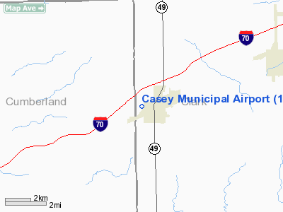
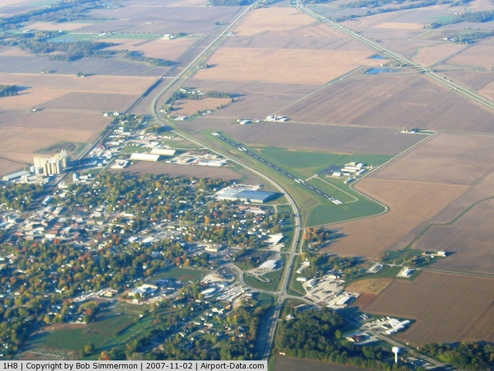
Location
& QuickFacts
|
FAA
Information Effective: |
2007-07-05 |
|
Airport
Identifier: |
1H8 |
|
Airport
Status: |
Operational |
|
Longitude/Latitude: |
088-00-14.6230W/39-18-09.0330N
-88.004062/39.302509 (Estimated) |
|
Elevation: |
654 ft / 199.34 m (Surveyed) |
|
Land: |
95 acres |
|
From
nearest city: |
1 nautical miles NW of Casey, IL |
|
Location: |
Clark County, IL |
|
Magnetic Variation: |
00W (1985) |
Owner
& Manager
|
Ownership: |
Publicly
owned |
|
Owner: |
City Of Casey |
|
Address: |
Po Box 425
Casey, IL 62420 |
|
Phone
number: |
217-932-2177 |
|
Manager: |
Chris White |
|
Address: |
2624 E Washington Street
Casey, IL 62420 |
|
Phone number: |
217-826-6352 |
Airport Operations and Facilities
|
Airport
Use: |
Open
to public |
|
Wind
indicator: |
Yes |
|
Segmented Circle: |
Yes |
|
Control
Tower: |
No |
|
Lighting
Schedule: |
DUSK-DAWN
MIRL RY 04/22 & REIL RYS 04 PRESET ON LOW INTST; TO
INCR INTST & ACTVT TWY LGTS - CTAF. |
|
Beacon
Color: |
Clear-Green (lighted land airport) |
|
Landing
fee charge: |
No |
|
Sectional chart: |
St Louis |
|
Region: |
AGL - Great Lakes |
|
Boundary
ARTCC: |
ZID - Indianapolis |
|
Tie-in
FSS: |
STL - Saint Louis |
|
FSS
on Airport: |
No |
|
FSS
Phone: |
636-536-2980 |
|
FSS
Toll Free: |
1-800-WX-BRIEF |
|
NOTAMs
Facility: |
STL (NOTAM-d service avaliable) |
|
Federal Agreements: |
NGY |
Airport Communications
|
CTAF: |
122.800 |
|
Unicom: |
122.800
|
Airport
Services
|
Fuel
available: |
100LL |
|
Airframe
Repair: |
MAJOR |
|
Power
Plant Repair: |
MAJOR |
|
Bottled
Oxygen: |
NONE |
|
Bulk
Oxygen: |
NONE |
|
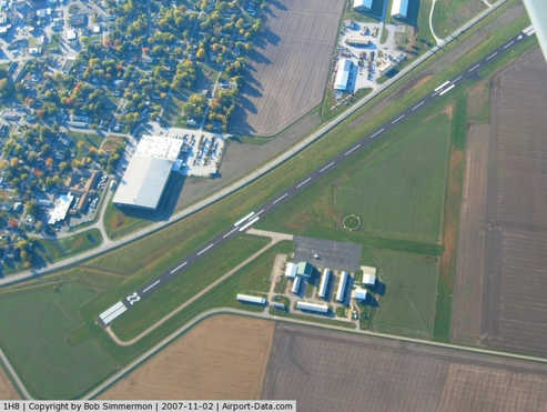
Runway Information
Runway 04/22
|
Dimension: |
4002
x 75 ft / 1219.8 x 22.9 m |
|
Surface: |
ASPH, Good Condition |
|
Weight
Limit: |
Single wheel: 12000 lbs. |
|
Edge
Lights: |
Medium |
|
|
Runway 04 |
Runway 22 |
|
Longitude: |
088-00-27.5760W |
087-59-55.5620W |
|
Latitude: |
39-17-52.5360N |
39-18-23.2860N |
|
Elevation: |
652.00 ft |
654.00 ft |
|
Alignment: |
39 |
127 |
|
Traffic
Pattern: |
Left |
Right |
|
Markings: |
Basic, Fair Condition |
Basic, Fair Condition |
|
Runway
End Identifier: |
Yes |
No |
|
Centerline
Lights: |
No |
No |
|
Touchdown
Lights: |
No |
No |
|
Obstruction: |
43 ft trees, 1269.0 ft from runway, 376 ft
left of centerline, 24:1 slope to clear |
12 ft road, 487.0 ft from runway, 273 ft right
of centerline, 23:1 slope to clear |
|
Runway 18/36
|
Dimension: |
1965
x 100 ft / 598.9 x 30.5 m |
|
Surface: |
TURF, Good Condition |
|
|
Runway 18 |
Runway 36 |
|
Longitude: |
088-00-21.1230W |
088-00-20.6230W |
|
Latitude: |
39-18-21.1320N |
39-18-01.6330N |
|
Traffic
Pattern: |
Right |
Left |
|
Displaced
threshold: |
315.00 ft |
0.00 ft |
|
Runway
End Identifier: |
No |
No |
|
Centerline
Lights: |
No |
No |
|
Touchdown
Lights: |
No |
No |
|
Obstruction: |
16 ft road, 5.0 ft from runway
APCH RATIO 20:1 TO DSPLCD THR. |
16 ft road, 530.0 ft from runway, 33:1 slope
to clear |
|
Radio Navigation
Aids
|
ID |
Type |
Name |
Ch |
Freq |
Var |
Dist |
|
CZB |
NDB |
Casey |
|
359.00 |
00E |
0.2 nm |
|
MT |
NDB |
Zebre |
|
347.00 |
00E |
11.5 nm |
|
PLX |
NDB |
Palestine |
|
391.00 |
00W |
24.3 nm |
|
PRG |
NDB |
Paris |
|
341.00 |
01E |
28.3 nm |
|
SIV |
NDB |
Sullivan |
|
326.00 |
02W |
28.3 nm |
|
HU |
NDB |
Yinno |
|
245.00 |
02W |
28.6 nm |
|
OLY |
NDB |
Olney |
|
272.00 |
00W |
36.0 nm |
|
SYZ |
NDB |
Shelbyville |
|
365.00 |
01E |
39.5 nm |
|
OEA |
NDB |
Vincennes |
|
251.00 |
00E |
42.3 nm |
|
FOA |
NDB |
Elm River |
|
353.00 |
00E |
43.5 nm |
|
AJG |
NDB |
Mount Carmel |
|
524.00 |
02W |
43.5 nm |
|
HMJ |
NDB |
Homer |
|
281.00 |
01E |
43.6 nm |
|
MTO |
VOR/DME |
Mattoon |
031X |
109.40 |
03E |
16.8 nm |
|
RSV |
VOR/DME |
Robinson |
021X |
108.40 |
02E |
23.8 nm |
|
LWV |
VOR/DME |
Lawrenceville |
025X |
108.80 |
01W |
37.1 nm |
|
SAM |
VOR/DME |
Samsville |
113X |
116.60 |
03E |
49.3 nm |
|
BIB |
VORTAC |
Bible Grove |
027X |
109.00 |
03E |
32.0 nm |
|
TTH |
VORTAC |
Terre Haute |
100X |
115.30 |
02E |
36.8 nm |
|
CMI |
VORTAC |
Champaign |
037X |
110.00 |
03E |
45.8 nm |
|
DEC |
VORTAC |
Decatur |
119X |
117.20 |
03E |
47.4 nm |
Remarks
- TPA
ESTABLISHED AT 800 FT AGL FOR ALL AIRCRAFT.
Based
Aircraft
|
Aircraft
based on field: |
22 |
|
Single
Engine Airplanes: |
15 |
|
Multi
Engine Airplanes: |
1 |
|
Ultralights: |
6 |
Operational Statistics
Time Period: 2005-10-01
- 2006-09-30
|
Aircraft
Operations: |
154/Week |
|
Air
Taxi: |
2.5% |
|
General
Aviation Local: |
62.5% |
|
General
Aviation Itinerant: |
34.4% |
|
Military: |
0.6% |
Casey Municipal Airport
Address:
Clark County, IL
Tel:
217-932-2177,
217-826-6352
Images
and information placed above are from
http://www.airport-data.com/airport/1H8/
We
thank them for the data!
| General
Info |
| Country |
United
States |
| State |
ILLINOIS
|
| FAA ID |
1H8 |
| Latitude |
39-18-09.033N
|
| Longitude |
088-00-14.623W
|
| Elevation |
654 feet
|
| Near City |
CASEY
|
We don't guarantee the information is fresh and accurate. The data may
be wrong or outdated.
For more up-to-date information please refer to other sources.
|
|


