 |
|
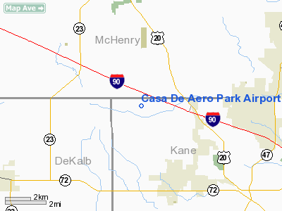
Casa De Aero Park Airport |
|
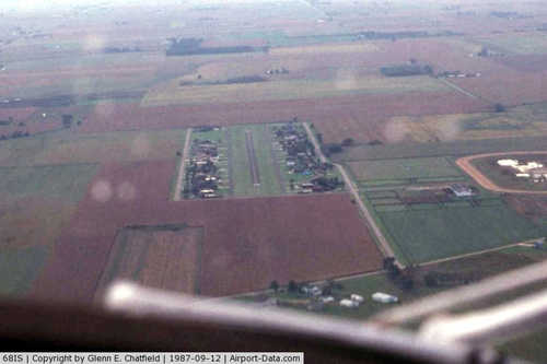 |
(Click on the photo to enlarge) |
|
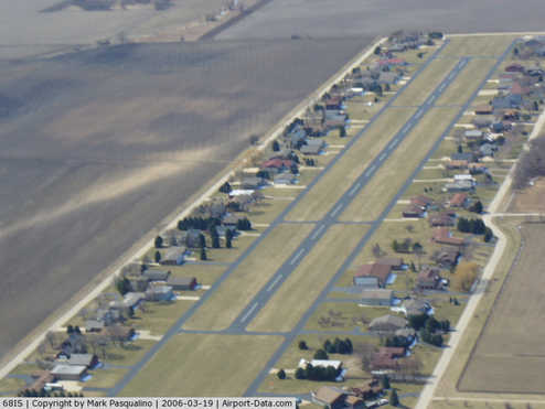 |
(Click on the photo to enlarge) |
Location
& QuickFacts
|
FAA
Information Effective: |
2007-07-05 |
|
Airport
Identifier: |
68IS |
|
Airport
Status: |
Operational |
|
Longitude/Latitude: |
088-33-35.3190W/42-08-55.0870N
-88.559811/42.148635 (Estimated) |
|
Elevation: |
860 ft / 262.13 m (Estimated) |
|
Land: |
0 acres |
|
From
nearest city: |
3 nautical miles NW of Hampshire, IL |
|
Location: |
Kane County, IL |
|
Magnetic Variation: |
02W (2005) |
Owner
& Manager
|
Ownership: |
Privately
owned |
|
Owner: |
Casa De Aero Park Corp. |
|
Address: |
P.o. Box 42
Hampshire, IL 60140 |
|
Phone
number: |
312-683-3832 |
|
Manager: |
Donald E Debolt |
|
Address: |
P.o. Box 42
Hampshire, IL 60140 |
|
Phone number: |
312-683-2885 |
Airport Operations and Facilities
|
Airport Use: |
Private |
|
Wind indicator: |
Yes |
|
Segmented Circle: |
Yes |
|
Control Tower: |
No |
|
Lighting Schedule: |
24 HRS |
|
Landing fee charge: |
No |
|
Sectional chart: |
Chicago |
|
Region: |
AGL - Great Lakes |
|
Boundary ARTCC: |
ZAU - Chicago |
|
Tie-in FSS: |
IKK - Kankakee |
|
FSS on Airport: |
No |
|
FSS Toll Free: |
1-800-WX-BRIEF |
Airport Services
|
Airframe
Repair: |
NONE |
|
Power
Plant Repair: |
NONE |
|
Runway Information
Runway 09/27
|
Dimension: |
3000
x 40 ft / 914.4 x 12.2 m |
|
Surface: |
ASPH, |
|
Edge
Lights: |
Low |
|
|
Runway 09 |
Runway 27 |
|
Longitude: |
088-34-02.9100W |
088-33-23.1100W |
|
Latitude: |
42-08-54.9600N |
42-08-54.9600N |
|
Elevation: |
747.00 ft |
738.00 ft |
|
Traffic
Pattern: |
Right |
Left |
|
Radio Navigation
Aids
|
ID |
Type |
Name |
Ch |
Freq |
Var |
Dist |
|
DKB |
NDB |
Dekalb |
|
209.00 |
02W |
14.5 nm |
|
ME |
NDB |
Deana |
|
350.00 |
00E |
26.2 nm |
|
LVV |
NDB |
Lake Lawn |
|
404.00 |
00W |
33.1 nm |
|
JVL |
NDB |
Janesville |
|
375.00 |
03E |
35.3 nm |
|
HK |
NDB |
Ermin |
|
332.00 |
01W |
41.4 nm |
|
RA |
NDB |
Paser |
|
206.00 |
00E |
43.5 nm |
|
MX |
NDB |
Kedzi |
|
248.00 |
01W |
46.0 nm |
|
FEP |
NDB |
Freeport |
|
335.00 |
00E |
46.1 nm |
|
OIX |
NDB |
Ottawa |
|
266.00 |
01E |
49.1 nm |
|
DPA |
VOR/DME |
Dupage |
021X |
108.40 |
02E |
18.1 nm |
|
OBK |
VOR/DME |
Northbrook |
077X |
113.00 |
02W |
27.4 nm |
|
RFD |
VOR/DME |
Rockford |
045X |
110.80 |
01E |
28.9 nm |
|
ORD |
VOR/DME |
Chicago O'hare |
086X |
113.90 |
02E |
30.8 nm |
|
BUU |
VOR/DME |
Burbun |
092X |
114.50 |
01W |
34.5 nm |
|
JVL |
VOR/DME |
Janesville |
090X |
114.30 |
03E |
34.5 nm |
|
ENW |
VOR/DME |
Kenosha |
029X |
109.20 |
02W |
38.9 nm |
|
PLL |
VOR/DME |
Polo |
049X |
111.20 |
03E |
44.4 nm |
|
HRK |
VOR/DME |
Horlick |
124X |
117.70 |
02W |
49.5 nm |
|
JOT |
VORTAC |
Joliet |
070X |
112.30 |
02E |
37.8 nm |
|
ORD |
VOT |
Chicago O'hare Intl |
|
112.00 |
|
30.8 nm |
|
MDW |
VOT |
Chicago Midway |
|
111.00 |
|
42.2 nm |
Remarks
- PROVIDING
COMPATIBLE TFC PATTERN IS ESTABD WITH ADJ ARPTS.
Based
Aircraft
|
Aircraft
based on field: |
92 |
|
Single
Engine Airplanes: |
68 |
|
Multi
Engine Airplanes: |
19 |
|
Helicopters: |
1 |
|
Gliders: |
2 |
|
Ultralights: |
2 |
Casa De Aero Park Airport
Address:
Kane County, IL
Tel:
312-683-3832,
312-683-2885
Images
and information placed above are from
http://www.airport-data.com/airport/68IS/
We
thank them for the data!
| General
Info |
| Country |
United
States |
| State |
ILLINOIS
|
| FAA ID |
68IS |
| Latitude |
42-08-55.087N
|
| Longitude |
088-33-35.319W
|
| Elevation |
860 feet
|
| Near City |
HAMPSHIRE
|
We don't guarantee the information is fresh and accurate. The data may
be wrong or outdated.
For more up-to-date information please refer to other sources.
|
|


