 |
|
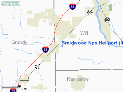
Location
& QuickFacts
|
FAA
Information Effective: |
2007-07-05 |
|
Airport
Identifier: |
IL49 |
|
Airport
Status: |
Operational |
|
Longitude/Latitude: |
088-13-49.2170W/41-14-30.1150N
-88.230338/41.241699 (Estimated) |
|
Elevation: |
602 ft / 183.49 m (Estimated) |
|
Land: |
4457 acres |
|
From
nearest city: |
0 nautical miles N of Godley, IL |
|
Location: |
Will County, IL |
|
Magnetic Variation: |
00W (1985) |
Owner
& Manager
|
Ownership: |
Privately
owned |
|
Owner: |
Commonwealth Edison Co |
|
Address: |
Rt 1 Po Box 84
Braceville, IL 60407 |
|
Phone
number: |
815-458-2801 |
|
Manager: |
Kurt Kofron |
|
Address: |
Rt 1 P.o. Box 84
Braceville, IL 60407 |
|
Phone number: |
815-458-2801
EXT 2212 |
Airport Operations and Facilities
|
Airport
Use: |
Private |
|
Wind
indicator: |
Yes |
|
Segmented Circle: |
No |
|
Control
Tower: |
No |
|
Sectional chart: |
Chicago |
|
Region: |
AGL - Great Lakes |
|
Boundary
ARTCC: |
ZAU - Chicago |
|
Tie-in
FSS: |
IKK - Kankakee |
|
FSS
Toll Free: |
1-800-WX-BRIEF |
|
Runway Information
Helipad H1
|
Dimension: |
40
x 40 ft / 12.2 x 12.2 m |
|
Surface: |
CONC, |
|
|
Runway H1 |
Runway |
|
Traffic
Pattern: |
Left |
Left |
|
Radio Navigation
Aids
|
ID |
Type |
Name |
Ch |
Freq |
Var |
Dist |
|
OIX |
NDB |
Ottawa |
|
266.00 |
01E |
29.1 nm |
|
HK |
NDB |
Ermin |
|
332.00 |
01W |
33.7 nm |
|
MX |
NDB |
Kedzi |
|
248.00 |
01W |
38.7 nm |
|
VYS |
NDB |
Valley |
|
230.00 |
00W |
42.0 nm |
|
ME |
NDB |
Deana |
|
350.00 |
00E |
44.6 nm |
|
DKB |
NDB |
Dekalb |
|
209.00 |
02W |
46.8 nm |
|
IKK |
VOR/DME |
Kankakee |
053X |
111.60 |
00E |
19.9 nm |
|
PNT |
VOR/DME |
Pontiac |
033X |
109.60 |
03E |
34.0 nm |
|
DPA |
VOR/DME |
Dupage |
021X |
108.40 |
02E |
39.4 nm |
|
RBS |
VOR/DME |
Roberts |
115X |
116.80 |
02E |
39.8 nm |
|
ORD |
VOR/DME |
Chicago O'hare |
086X |
113.90 |
02E |
47.2 nm |
|
JOT |
VORTAC |
Joliet |
070X |
112.30 |
02E |
18.7 nm |
|
EON |
VORTAC |
Peotone |
079X |
113.20 |
02E |
19.9 nm |
|
CGT |
VORTAC |
Chicago Heights |
089X |
114.20 |
02E |
33.8 nm |
|
MDW |
VOT |
Chicago Midway |
|
111.00 |
|
39.2 nm |
|
ORD |
VOT |
Chicago O'hare Intl |
|
112.00 |
|
46.8 nm |
Remarks
- LIGHT
POLES 50'HIGH APPROXIMATELY 150' FROM HELIPORT
- BLDGS
200'AGL APPROXIMATELY 1000' NORTH OF HELIPORT
- PRVDD
OPS ARE CONDUCTED FROM 70 TO 110 & FROM 250 TO 290;AREA IS MARKED;WIND
INDICATOR IS MAINTAINED
Braidwood Nps Heliport
Address:
Will County, IL
Tel:
815-458-2801
Images
and information placed above are from
http://www.airport-data.com/airport/IL49/
We
thank them for the data!
| General
Info |
| Country |
United
States |
| State |
ILLINOIS
|
| FAA ID |
IL49 |
| Latitude |
41-14-30.115N
|
| Longitude |
088-13-49.217W
|
| Elevation |
602 feet
|
| Near City |
GODLEY
|
We don't guarantee the information is fresh and accurate. The data may
be wrong or outdated.
For more up-to-date information please refer to other sources.
|
|


