 |
|
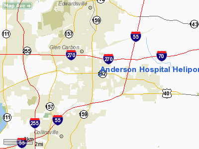
Anderson Hospital Heliport |
|
|
Location
& QuickFacts
|
FAA
Information Effective: |
2007-07-05 |
|
Airport
Identifier: |
8IS9 |
|
Airport
Status: |
Operational |
|
Longitude/Latitude: |
089-56-48.3630W/38-44-13.1730N
-89.946768/38.736992 (Estimated) |
|
Elevation: |
590 ft / 179.83 m (Estimated) |
|
Land: |
0 acres |
|
From
nearest city: |
1 nautical miles NE of Maryville, IL |
|
Location: |
Madison County, IL |
|
Magnetic Variation: |
02E (1985) |
Owner
& Manager
|
Ownership: |
Privately
owned |
|
Owner: |
Sw Il Health Facilities |
|
Address: |
162 Old Edwardsville Rd
Maryville, IL 62062 |
|
Phone
number: |
618-288-5711 |
|
Manager: |
Bill Eck |
|
Address: |
162 Old Edwardsville Rd
Maryville, IL 62062 |
|
Phone number: |
618-288-5711 |
Airport Operations and Facilities
|
Airport
Use: |
Private
MEDICAL USE. |
|
Wind
indicator: |
Yes |
|
Segmented Circle: |
No |
|
Control
Tower: |
No |
|
Lighting
Schedule: |
PHONE REQ
BCN TURNED ON PRIOR TO ARRIVAL OF HELO REQUESTED BY HOSPITAL. |
|
Beacon
Color: |
Clear-Green-Yellow (heliport) |
|
Sectional chart: |
St Louis |
|
Region: |
AGL - Great Lakes |
|
Boundary
ARTCC: |
ZKC - Kansas City |
|
Tie-in
FSS: |
COU - Columbia |
|
FSS
on Airport: |
No |
|
FSS
Toll Free: |
1-800-WX-BRIEF |
|
Runway Information
Helipad H1
|
Dimension: |
40
x 40 ft / 12.2 x 12.2 m |
|
Surface: |
CONC, |
|
|
Runway H1 |
Runway |
|
Traffic
Pattern: |
Left |
Left |
|
Radio Navigation
Aids
|
ID |
Type |
Name |
Ch |
Freq |
Var |
Dist |
|
CVM |
NDB |
Civic Memorial |
|
263.00 |
02E |
10.7 nm |
|
BL |
NDB |
Belleville |
|
362.00 |
02E |
18.6 nm |
|
LM |
NDB |
Oblio |
|
338.00 |
00E |
25.0 nm |
|
LTD |
NDB |
Litchfield |
|
371.00 |
01E |
28.7 nm |
|
SAR |
NDB |
Sparta |
|
239.00 |
01E |
37.4 nm |
|
FES |
NDB |
Festus |
|
269.00 |
01E |
38.6 nm |
|
SLO |
NDB |
Salem |
|
400.00 |
01W |
46.3 nm |
|
SKE |
TACAN |
Scott |
059X |
|
02E |
12.4 nm |
|
CSX |
VOR/DME |
Cardinal |
111Y |
116.45 |
00E |
19.4 nm |
|
TOY |
VORTAC |
Troy |
107X |
116.00 |
04E |
1.3 nm |
|
STL |
VORTAC |
St Louis |
121X |
117.40 |
01E |
26.2 nm |
|
ENL |
VORTAC |
Centralia |
097X |
115.00 |
04E |
41.6 nm |
|
VLA |
VORTAC |
Vandalia |
090X |
114.30 |
04E |
42.5 nm |
|
FTZ |
VORTAC |
Foristell |
045X |
110.80 |
05E |
48.1 nm |
|
STL |
VOT |
St Louis Lambert |
|
111.00 |
|
19.5 nm |
|
SUS |
VOT |
Spirit Of St Louis |
|
112.20 |
|
33.4 nm |
Remarks
- SEE
AIRSPACE CASE 98-AGL-215-NRA.
Anderson Hospital Heliport
Address:
Madison County, IL
Tel:
618-288-5711
Images
and information placed above are from
http://www.airport-data.com/airport/8IS9/
We
thank them for the data!
| General
Info |
| Country |
United
States |
| State |
ILLINOIS
|
| FAA ID |
8IS9 |
| Latitude |
38-44-13.173N
|
| Longitude |
089-56-48.363W
|
| Elevation |
590 feet
|
| Near City |
MARYVILLE
|
We don't guarantee the information is fresh and accurate. The data may
be wrong or outdated.
For more up-to-date information please refer to other sources.
|
|


