 |
|
|
|
|
|
Location
& QuickFacts
|
FAA
Information Effective: |
2007-07-05 |
|
Airport
Identifier: |
S87 |
|
Airport
Status: |
Operational |
|
Longitude/Latitude: |
116-57-37.8750W/44-12-16.7750N
-116.960521/44.204660 (Estimated) |
|
Elevation: |
2120 ft / 646.18 m (Estimated) |
|
Land: |
135 acres |
|
From
nearest city: |
3 nautical miles S of Weiser, ID |
|
Location: |
Washington County, ID |
|
Magnetic
Variation: |
18E (1985) |
Owner
& Manager
|
Ownership: |
Publicly
owned |
|
Owner: |
City Weiser |
|
Address: |
55 West Idaho St
Weiser, ID 83672 |
|
Phone
number: |
208-414-1965 |
|
Manager: |
Frank Thompson |
|
Address: |
1364 Hansen Road
Weiser, ID 83672 |
|
Phone
number: |
208-549-0712 |
Airport
Operations and Facilities
|
Airport
Use: |
Open
to public |
|
Wind
indicator: |
Yes |
|
Segmented Circle: |
Yes |
|
Control
Tower: |
No |
|
Lighting
Schedule: |
DUSK-DAWN
ACTVT MIRL RY 12/30 & REIL RYS 12 & 30 - CTAF.
PAPI
RY 30 OPR CONTINUOUSLY. |
|
Beacon
Color: |
Clear-Green (lighted land airport) |
|
Landing
fee charge: |
No |
|
Sectional chart: |
Salt Lake City |
|
Region: |
ANM - Northwest Mountain |
|
Boundary
ARTCC: |
ZLC - Salt Lake City |
|
Tie-in
FSS: |
BOI - Boise |
|
FSS
on Airport: |
No |
|
FSS
Phone: |
208-332-0200 |
|
FSS
Toll Free: |
1-800-WX-BRIEF |
|
NOTAMs
Facility: |
BOI (NOTAM-d service avaliable) |
|
Federal
Agreements: |
NGY |
Airport
Communications
|
CTAF: |
122.800 |
|
Unicom: |
122.800
|
Airport
Services
|
Fuel
available: |
100LL |
|
Airframe
Repair: |
MINOR |
|
Power
Plant Repair: |
MINOR |
|
Bottled
Oxygen: |
NONE |
|
Bulk
Oxygen: |
NONE |
|
Runway Information
Runway 12/30
|
Dimension: |
4000
x 60 ft / 1219.2 x 18.3 m |
|
Surface: |
ASPH, Good Condition |
|
Weight
Limit: |
Single wheel: 12500 lbs. |
|
Edge
Lights: |
Medium |
|
|
Runway 12 |
Runway 30 |
|
Longitude: |
116-57-57.0000W |
116-57-18.7500W |
|
Latitude: |
44-12-30.9400N |
44-12-02.6100N |
|
Elevation: |
2111.00 ft |
2120.00 ft |
|
Alignment: |
127 |
127 |
|
Traffic
Pattern: |
Left |
Left |
|
Markings: |
Non-precision instrument, Good Condition |
Non-precision instrument, Good Condition |
|
Crossing
Height: |
0.00 ft |
50.00 ft |
|
VASI: |
|
4-light PAPI on left side |
|
Visual
Glide Angle: |
0.00° |
3.00° |
|
Runway
End Identifier: |
Yes |
Yes |
|
Obstruction: |
35 ft trees, 950.0 ft from runway, 21:1 slope
to clear |
, 50:1 slope to clear |
|
Radio Navigation
Aids
|
ID |
Type |
Name |
Ch |
Freq |
Var |
Dist |
|
ONO |
NDB |
Ontario |
|
305.00 |
17E |
11.3 nm |
|
MPA |
NDB |
Meridian |
|
238.00 |
16E |
40.5 nm |
|
BO |
NDB |
Ustik |
|
359.00 |
17E |
46.0 nm |
|
DNJ |
VORTAC |
Donnelly |
109X |
116.20 |
19E |
46.8 nm |
|
BOI |
VOT |
Boise |
|
116.70 |
|
49.5 nm |
Remarks
- EXTSV
AGRICULTURAL OPNS MAR-OCT.
- BIRDS
ON & INVOF ARPT.
- ESTABD
PRIOR TO 15 MAY 1959.
Based
Aircraft
|
Aircraft
based on field: |
45 |
|
Single
Engine Airplanes: |
41 |
|
Multi
Engine Airplanes: |
2 |
|
Ultralights: |
2 |
Operational Statistics
Time Period: 2005-12-08
- 2006-12-07
|
Aircraft
Operations: |
47/Day |
|
General
Aviation Local: |
90.6% |
|
General
Aviation Itinerant: |
8.2% |
|
Military: |
1.2% |
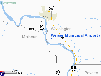
Weiser Municipal Airport
Address:
Washington County, ID
Tel:
208-414-1965,
208-549-0712
Images
and information placed above are from
http://www.airport-data.com/airport/S87/
We
thank them for the data!
| General
Info |
| Country |
United
States |
| State |
IDAHO
|
| FAA ID |
S87 |
| Latitude |
44-12-24.590N
|
| Longitude |
116-57-44.593W
|
| Elevation |
2112 feet
|
| Near City |
WEISER
|
We don't guarantee the information is fresh and accurate. The data may
be wrong or outdated.
For more up-to-date information please refer to other sources.
|
|


