 |
|
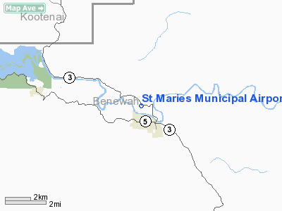
St Maries Municipal Airport |
|
|
Location
& QuickFacts
|
FAA
Information Effective: |
2007-07-05 |
|
Airport
Identifier: |
S72 |
|
Airport
Status: |
Operational |
|
Longitude/Latitude: |
116-34-38.6060W/47-19-39.6740N
-116.577391/47.327687 (Estimated) |
|
Elevation: |
2127 ft / 648.31 m (Surveyed) |
|
Land: |
65 acres |
|
From
nearest city: |
1 nautical miles NW of St Maries, ID |
|
Location: |
Benewah County, ID |
|
Magnetic
Variation: |
19E (1985) |
Owner
& Manager
|
Ownership: |
Publicly
owned |
|
Owner: |
Benewah County |
|
Address: |
Benewah County Courthouse
St Maries, ID 83861 |
|
Phone
number: |
208-245-2234 |
|
Manager: |
Dale Pritchard |
|
Address: |
Hc 2 Box 8
St Maries, ID 83861 |
|
Phone
number: |
208-245-4258 |
Airport
Operations and Facilities
|
Airport
Use: |
Open
to public |
|
Wind
indicator: |
Yes |
|
Segmented Circle: |
Yes |
|
Control
Tower: |
No |
|
Lighting
Schedule: |
DUSK-DAWN
ACTVT NSTD MIRL RY 10/28 AND PAPI RY 10 - CTAF. |
|
Beacon
Color: |
Clear-Green (lighted land airport) |
|
Landing
fee charge: |
No |
|
Sectional chart: |
Great Falls |
|
Region: |
ANM - Northwest Mountain |
|
Boundary
ARTCC: |
ZSE - Seattle |
|
Tie-in
FSS: |
BOI - Boise |
|
FSS
on Airport: |
No |
|
FSS
Phone: |
208-332-0200 |
|
FSS
Toll Free: |
1-800-WX-BRIEF |
|
NOTAMs
Facility: |
BOI (NOTAM-d service avaliable) |
|
Federal
Agreements: |
NGY |
Airport
Communications
|
CTAF: |
122.800 |
|
Unicom: |
122.800
|
Airport
Services
|
Fuel
available: |
100LL |
|
Airframe
Repair: |
MINOR |
|
Power
Plant Repair: |
MINOR |
|
Bottled
Oxygen: |
NONE |
|
Bulk
Oxygen: |
NONE |
|
Runway Information
Runway 10/28
|
Dimension: |
4250
x 60 ft / 1295.4 x 18.3 m |
|
Surface: |
ASPH, Good Condition |
|
Weight
Limit: |
Single wheel: 12500 lbs. |
|
Edge
Lights: |
Non-standard lighting system
RWY 10/28 NSTD MIRL FIRST 715 FT WEST END NOT LIGHTED. |
|
|
Runway 10 |
Runway 28 |
|
Traffic
Pattern: |
Right |
Left |
|
Markings: |
Basic, Good Condition
RWY 10 NSTD DSPLCD THR MARKING YELLOW CHEVRONS |
Basic, Good Condition |
|
Crossing
Height: |
39.00 ft |
0.00 ft |
|
Displaced
threshold: |
715.00 ft |
0.00 ft |
|
VASI: |
2-light PAPI on left side |
|
|
Visual
Glide Angle: |
4.00° |
0.00° |
|
Obstruction: |
50 ft trees, 750.0 ft from runway, 11:1 slope
to clear
RWY 10 DSPLCD FOR 45' ROAD AT 0';30 FT R; 15:1 FM DSPLCD THLD.
RWY 10 45 FT ROAD, 0'; 30 FT R OF RWY CNTRLN. |
80 ft trees, 1200.0 ft from runway, 150 ft
right of centerline, 12:1 slope to clear |
|
Radio Navigation
Aids
|
ID |
Type |
Name |
Ch |
Freq |
Var |
Dist |
|
SFF |
NDB |
Felts |
|
365.00 |
19E |
36.8 nm |
|
SKA |
TACAN |
Fairchild |
051X |
|
19E |
47.3 nm |
|
COE |
VOR/DME |
Coeur D'alene |
025X |
108.80 |
19E |
28.6 nm |
|
MLP |
VOR/DME |
Mullan Pass |
125X |
117.80 |
20E |
38.7 nm |
|
PUW |
VOR/DME |
Pullman |
027X |
109.00 |
20E |
47.4 nm |
|
GEG |
VORTAC |
Spokane |
102X |
115.50 |
21E |
45.0 nm |
|
SFF |
VOT |
Spokane/felts Field |
|
114.00 |
|
36.9 nm |
|
GEG |
VOT |
Spokane Intl |
|
109.60 |
|
43.0 nm |
Remarks
- ULTRALIGHT
ACFT PATTERN ESTABLISHED FOR RY 10 NW OF RY; RIGHT TRAFFIC.
- RY
28 HAS 200 FT STOPWAY.
- ESTABD
PRIOR TO 15 MAY 59.
Based
Aircraft
|
Aircraft
based on field: |
22 |
|
Single
Engine Airplanes: |
20 |
|
Multi
Engine Airplanes: |
2 |
Operational Statistics
Time Period: 2005-06-07
- 2006-06-06
|
Aircraft
Operations: |
252/Week |
|
General
Aviation Local: |
35.9% |
|
General
Aviation Itinerant: |
64.1% |
St Maries Municipal Airport
Address:
Benewah County, ID
Tel:
208-245-2234,
208-245-4258
Images
and information placed above are from
http://www.airport-data.com/airport/S72/
We
thank them for the data!
| General
Info |
| Country |
United
States |
| State |
IDAHO
|
| FAA ID |
S72 |
| Latitude |
47-19-39.674N
|
| Longitude |
116-34-38.606W
|
| Elevation |
2127 feet
|
| Near City |
ST MARIES
|
We don't guarantee the information is fresh and accurate. The data may
be wrong or outdated.
For more up-to-date information please refer to other sources.
|
|


