|
|
Pocatello Regional Airport |
| Pocatello Regional Airport |
 |
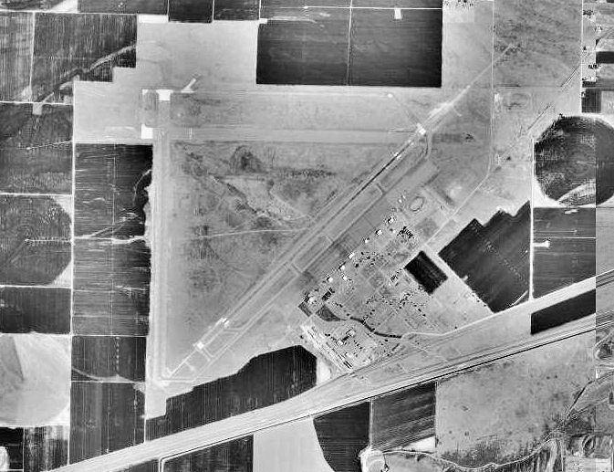
| 1992 USGS photo |
| IATA: PIH â ICAO: KPIH |
| Summary |
| Airport type |
Public |
| Operator |
City of Pocatello |
| Serves |
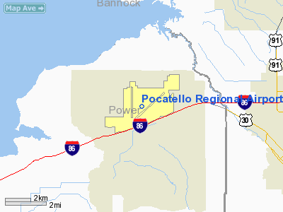
Pocatello, Idaho |
| Elevation AMSL |
4,452 ft / 1357 m |
| Coordinates |
42°54â²35.3â³N 112°35â²45.3â³W / 42.909806°N 112.595917°W / 42.909806; -112.595917 |
| Runways |
| Direction |
Length |
Surface |
| ft |
m |
| 3/21 |
9,060 |
2,761 |
Asphalt |
| 17/35 |
7,150 |
2,179 |
Asphalt |
Pocatello Regional Airport (IATA: PIH, ICAO: KPIH) is a public airport located about 7 miles west of the city of Pocatello, in Power County, Idaho, USA. The airport has two runways. The airport is built on the site of the Pocatello Army Airfield, a World War II training base. Many of the base facilities have been razed, although four large hangars remain. Airlines and destinations
| Airlines |
Destinations |
| Delta Connection operated by SkyWest Airlines |
Salt Lake City |
History
In 1943, the Pocatello Army Airfield was built as a Second Air Force heavy bomber (B-17, B-24) training base.
In 1949, it became surplus property and was obtained by the city of Pocatello to build a commercial airport.
The above content comes from Wikipedia and is published under free licenses – click here to read more.
Location
& QuickFacts
|
FAA
Information Effective: |
2007-07-05 |
|
Airport
Identifier: |
PIH |
|
Airport
Status: |
Operational |
|
Longitude/Latitude: |
112-35-45.3000W/42-54-35.3000N
-112.595917/42.909806 (Estimated) |
|
Elevation: |
4452 ft / 1356.97 m (Surveyed) |
|
Land: |
3374 acres |
|
From
nearest city: |
7 nautical miles NW of Pocatello, ID |
|
Location: |
Power County, ID |
|
Magnetic
Variation: |
14E (2005) |
Owner
& Manager
|
Ownership: |
Publicly
owned |
|
Owner: |
City Of Pocatello |
|
Address: |
City Hall
Pocatello, ID 83201 |
|
Phone
number: |
208-234-6154 |
|
Manager: |
Lenard Nelson |
|
Address: |
Box 4169
Pocatello, ID 83205-4169 |
|
Phone
number: |
208-234-6154 |
Airport
Operations and Facilities
|
Airport
Use: |
Open
to public |
|
Wind
indicator: |
Yes |
|
Segmented Circle: |
Yes |
|
Control
Tower: |
Yes |
|
Lighting
Schedule: |
DUSK-DAWN
AFTER ATCT CLSD ACTVT MIRL RY 17/35; HIRL RY 03/21; ODALS
RY 03 & MALSR RY 21 - CTAF. |
|
Beacon
Color: |
Clear-Green (lighted land airport) |
|
Landing
fee charge: |
No |
|
Sectional chart: |
Salt Lake City |
|
Region: |
ANM - Northwest Mountain |
|
Boundary
ARTCC: |
ZLC - Salt Lake City |
|
Tie-in
FSS: |
BOI - Boise |
|
FSS
on Airport: |
No |
|
FSS
Phone: |
208-332-0200 |
|
FSS
Toll Free: |
1-800-WX-BRIEF |
|
NOTAMs
Facility: |
PIH (NOTAM-d service avaliable) |
|
Certification type/date: |
II A S 04/197
PPR FOR UNSKED ACR OPNS WITH MORE THAN 30 PSGR SEATS CALL
AMGR 208-234-6154 OR 208-237-4738. |
|
Federal
Agreements: |
NGPY |
Airport
Communications
|
CTAF: |
119.100 |
|
Unicom: |
122.950
|
Airport
Services
|
Fuel
available: |
100LLA1
A1+
FBO MONITORS 122.95 & 123.0. |
|
Airframe
Repair: |
MAJOR |
|
Power
Plant Repair: |
MAJOR |
|
Bottled
Oxygen: |
HIGH/LOW |
|
Runway Information
Runway 03/21
|
Dimension: |
9060
x 150 ft / 2761.5 x 45.7 m |
|
Surface: |
ASPH, Good Condition |
|
Surface
Treatment: |
Porous Friction Course |
|
Weight
Limit: |
Single wheel: 100000 lbs.
Dual wheel: 160000 lbs.
Dual tandem wheel: 265000 lbs. |
|
Edge
Lights: |
High |
|
|
Runway 03 |
Runway 21 |
|
Longitude: |
112-36-02.8035W |
112-34-36.7772W |
|
Latitude: |
42-54-06.1456N |
42-55-09.4425N |
|
Elevation: |
4442.00 ft |
4448.00 ft |
|
Alignment: |
45 |
127 |
|
ILS
Type: |
|
ILS/DME |
|
Traffic
Pattern: |
Left |
Left |
|
Markings: |
Non-precision instrument, Good Condition |
Precision instrument, Good Condition |
|
Crossing
Height: |
53.00 ft |
58.00 ft |
|
VASI: |
4-box on left side |
4-light PAPI on left side |
|
Visual
Glide Angle: |
3.00° |
3.00° |
|
Approach
lights: |
ODALS |
MALSR |
|
Runway 17/35
|
Dimension: |
7150
x 100 ft / 2179.3 x 30.5 m |
|
Surface: |
ASPH, Good Condition |
|
Weight
Limit: |
Single wheel: 60000 lbs. |
|
Edge
Lights: |
Medium |
|
|
Runway 17 |
Runway 35 |
|
Longitude: |
112-36-17.6654W |
112-36-17.5883W |
|
Latitude: |
42-55-07.3314N |
42-53-56.7246N |
|
Elevation: |
4447.00 ft |
4442.00 ft |
|
Alignment: |
127 |
127 |
|
Traffic
Pattern: |
Left |
Left |
|
Markings: |
Basic, Fair Condition |
Basic, Fair Condition |
|
Crossing
Height: |
45.00 ft |
45.00 ft |
|
VASI: |
4-light PAPI on left side |
4-light PAPI on left side |
|
Visual
Glide Angle: |
3.00° |
3.00° |
|
Runway
End Identifier: |
Yes |
|
|
Obstruction: |
, 50:1 slope to clear |
42 ft pole, 2030.0 ft from runway, 50 ft right
of centerline, 43:1 slope to clear |
|
Radio Navigation
Aids
|
ID |
Type |
Name |
Ch |
Freq |
Var |
Dist |
|
SWU |
NDB |
Sweden |
|
350.00 |
15E |
36.7 nm |
|
MLD |
VOR/DME |
Malad City |
121X |
117.40 |
17E |
43.1 nm |
|
IDA |
VOR/DME |
Idaho Falls |
85Y |
113.85 |
15E |
43.4 nm |
|
PIH |
VORTAC |
Pocatello |
073X |
112.60 |
17E |
3.4 nm |
Remarks
- FLOCKS
OF WATERFOWL IN VCNTY ARPT.
- RY
17/35 NOT AVBL TO ACR OPNS WITH MORE THAN 30 PSGR SEATS.
- RADIO
CONTROLLED ACFT 1 MI E OF ARPT BLO 400 FT AGL.
- TWY
'G' HAS NO EDGE LIGHTS OR REFLECTORS, RESTRICTED TO DAY USE ONLY.
Based
Aircraft
|
Aircraft
based on field: |
70 |
|
Single
Engine Airplanes: |
47 |
|
Multi
Engine Airplanes: |
21 |
|
Jet
Engine Airplanes: |
1 |
|
Helicopters: |
1 |
Major Carriers
Serving This Airport
|
Skywest Airlines Inc. |
100.0% |
Most Popular Destinations
|
Salt Lake City Intl (SLC) |
100.0% |
Most Popular Aircraft
|
N291SW |
6.8% |
|
N576SW |
6.4% |
|
N566SW |
6.2% |
|
N236SW |
5.7% |
|
N216SW |
5.3% |
|
N308SW |
4.8% |
|
N563SW |
4.4% |
|
N297SW |
3.7% |
|
N580SW |
3.7% |
|
N224SW |
3.7% |
Operational Statistics
Time Period: 2005-03-01
- 2006-02-28
|
Aircraft
Operations: |
127/Day |
|
Commerical: |
14.3% |
|
Air
Taxi: |
7.9% |
|
General
Aviation Local: |
43.1% |
|
General
Aviation Itinerant: |
33.5% |
|
Military: |
1.2% |
Pocatello Regional Airport
Address:
Power County, ID
Tel:
208-234-6154
Images
and information placed above are from
http://www.airport-data.com/airport/PIH/
We
thank them for the data!
| General
Info |
| Country |
United
States |
| State |
IDAHO
|
| FAA ID |
PIH |
| Latitude |
42-54-35.200N
|
| Longitude |
112-35-45.300W
|
| Elevation |
4452 feet
|
| Near City |
POCATELLO
|
We don't guarantee the information is fresh and accurate. The data may
be wrong or outdated.
For more up-to-date information please refer to other sources.
|
|