 |
|
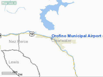
Orofino Municipal Airport |
|
|
Location
& QuickFacts
|
FAA
Information Effective: |
2007-07-05 |
|
Airport
Identifier: |
S68 |
|
Airport
Status: |
Operational |
|
Longitude/Latitude: |
116-16-36.5020W/46-29-28.6490N
-116.276806/46.491291 (Estimated) |
|
Elevation: |
1005 ft / 306.32 m (Estimated) |
|
Land: |
31 acres |
|
From
nearest city: |
1 nautical miles NW of Orofino, ID |
|
Location: |
Clearwater County, ID |
|
Magnetic
Variation: |
18E (1985) |
Owner
& Manager
|
Ownership: |
Publicly
owned |
|
Owner: |
City Of Orofino |
|
Address: |
Po Box 312
Orofino, ID 83544 |
|
Phone
number: |
208-476-4725 |
|
Manager: |
Dave Petet |
|
Address: |
Airport Rd. No 1
Orofino, ID 83544 |
|
Phone
number: |
208-476-4714 |
Airport
Operations and Facilities
|
Airport
Use: |
Open
to public |
|
Wind
indicator: |
Yes |
|
Segmented Circle: |
No |
|
Control
Tower: |
No |
|
Landing
fee charge: |
No |
|
Sectional chart: |
Great Falls |
|
Region: |
ANM - Northwest Mountain |
|
Boundary
ARTCC: |
ZSE - Seattle |
|
Tie-in
FSS: |
BOI - Boise |
|
FSS
on Airport: |
No |
|
FSS
Phone: |
208-332-0200 |
|
FSS
Toll Free: |
1-800-WX-BRIEF |
|
NOTAMs
Facility: |
BOI (NOTAM-d service avaliable) |
|
Federal
Agreements: |
NGY |
Airport
Communications
|
CTAF: |
122.800 |
|
Unicom: |
122.800
|
Airport
Services
|
Fuel
available: |
100LL |
|
Airframe
Repair: |
NONE |
|
Power
Plant Repair: |
NONE |
|
Bottled
Oxygen: |
NONE |
|
Bulk
Oxygen: |
NONE |
|
Runway Information
Runway 09/27
|
Dimension: |
2500
x 50 ft / 762.0 x 15.2 m |
|
Surface: |
ASPH, Fair Condition |
|
Weight
Limit: |
Single wheel: 17000 lbs. |
|
|
Runway 09 |
Runway 27 |
|
Traffic
Pattern: |
Right |
Left |
|
Markings: |
Basic, Good Condition |
Basic, Good Condition |
|
Obstruction: |
60 ft trees, 225.0 ft from runway, 75 ft right
of centerline |
13 ft road, 200.0 ft from runway, 80 ft right
of centerline
+13 FT ROAD AT 0 FT 110 FT R OF CNTRLN. |
|
Radio Navigation
Aids
|
ID |
Type |
Name |
Ch |
Freq |
Var |
Dist |
|
GVV |
NDB |
Grain |
|
280.00 |
18E |
33.2 nm |
|
MQG |
VOR/DME |
Nez Perce |
019X |
108.20 |
20E |
25.4 nm |
|
PUW |
VOR/DME |
Pullman |
027X |
109.00 |
20E |
40.6 nm |
Remarks
- HIGH
TERRAIN IN ALL QUADS AROUND ARPT.
- TWO
1968 FT MSL (250 FT AGL) RADIO TWRS LOCATED APPROXIMATELY 1 MILE E OF
RY 27 300 FT LEFT.
Based
Aircraft
|
Aircraft
based on field: |
14 |
|
Single
Engine Airplanes: |
14 |
Operational Statistics
Time Period: 2005-06-07
- 2006-06-06
|
Aircraft
Operations: |
143/Week |
|
Air
Taxi: |
24.3% |
|
General
Aviation Local: |
14.9% |
|
General
Aviation Itinerant: |
60.8% |
Orofino Municipal Airport
Address:
Clearwater County, ID
Tel:
208-476-4725,
208-476-4714
Images
and information placed above are from
http://www.airport-data.com/airport/S68/
We
thank them for the data!
| General
Info |
| Country |
United
States |
| State |
IDAHO
|
| FAA ID |
S68 |
| Latitude |
46-29-28.649N
|
| Longitude |
116-16-36.502W
|
| Elevation |
1005 feet
|
| Near City |
OROFINO
|
We don't guarantee the information is fresh and accurate. The data may
be wrong or outdated.
For more up-to-date information please refer to other sources.
|
|


