 |
|
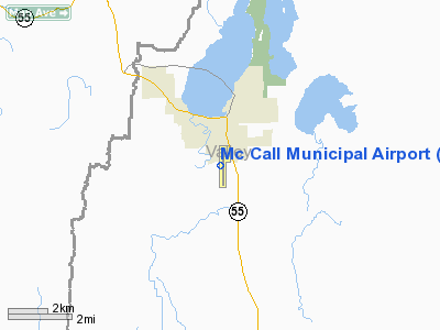
Mc Call Municipal Airport |
| McCall Municipal Airport |
| IATA: MYL â ICAO: KMYL |
| Summary |
| Airport type |
Public |
| Operator |
City of McCall |
| Location |
McCall, Idaho |
| Elevation AMSL |
5,021 ft / 1,530 m |
| Coordinates |
44°53â²23â³N 116°06â²05â³W / 44.88972°N 116.10139°W / 44.88972; -116.10139Coordinates: 44°53â²23â³N 116°06â²05â³W / 44.88972°N 116.10139°W / 44.88972; -116.10139 |
| Runways |
| Direction |
Length |
Surface |
| ft |
m |
| 16/34 |
6,107 |
1,861 |
Asphalt |
McCall Municipal Airport (IATA: MYL, ICAO: KMYL) is a public airport located in McCall, a city in Valley County, Idaho, USA. The airport covers 197 acres (80 ha) and has one asphalt runway, 6107 feet (1807 m) in length and running due north-south.
It is home to a U.S. Forest Service smokejumper base, one of eight in the nation.
The airport was the site of a fatal crash on May 2, 2008, when two single-engine planes collided on final approach and exploded, resulting in three deaths.
Airlines
| Airlines |
Destinations |
| Salmon Air |
Boise, Salmon |
The above content comes from Wikipedia and is published under free licenses – click here to read more.
Location
& QuickFacts
|
FAA
Information Effective: |
2007-07-05 |
|
Airport
Identifier: |
MYL |
|
Airport
Status: |
Operational |
|
Longitude/Latitude: |
116-06-06.3100W/44-53-19.6900N
-116.101753/44.888803 (Estimated) |
|
Elevation: |
5024 ft / 1531.32 m (Estimated) |
|
Land: |
197 acres |
|
From
nearest city: |
0 nautical miles S of Mc Call, ID |
|
Location: |
Valley County, ID |
|
Magnetic
Variation: |
17E (1995) |
Owner
& Manager
|
Ownership: |
Publicly
owned |
|
Owner: |
City Of Mccall |
|
Address: |
216 E Park
Mc Call, ID 83638 |
|
Phone
number: |
208-634-7142 |
|
Manager: |
John Anderson |
|
Address: |
216 E Park
Mc Call, ID 83638 |
|
Phone
number: |
208-634-1488 |
Airport
Operations and Facilities
|
Airport
Use: |
Open
to public |
|
Wind
indicator: |
Yes |
|
Segmented Circle: |
Yes |
|
Control
Tower: |
No |
|
Lighting
Schedule: |
DUSK-DAWN |
|
Beacon
Color: |
Clear-Green (lighted land airport) |
|
Landing
fee charge: |
No |
|
Sectional chart: |
Great Falls |
|
Region: |
ANM - Northwest Mountain |
|
Boundary
ARTCC: |
ZLC - Salt Lake City |
|
Tie-in
FSS: |
BOI - Boise |
|
FSS
on Airport: |
No |
|
FSS
Phone: |
208-332-0200 |
|
FSS
Toll Free: |
1-800-WX-BRIEF |
|
NOTAMs
Facility: |
MYL (NOTAM-d service avaliable) |
|
Federal
Agreements: |
NGY |
Airport
Communications
|
CTAF: |
122.800 |
|
Unicom: |
122.800
|
Airport
Services
|
Fuel
available: |
100LLA
A1+ |
|
Airframe
Repair: |
MAJOR |
|
Power
Plant Repair: |
MAJOR |
|
Bottled
Oxygen: |
NONE |
|
Bulk
Oxygen: |
NONE |
|
Runway Information
Runway 16/34
|
Dimension: |
6054
x 75 ft / 1845.3 x 22.9 m |
|
Surface: |
ASPH, Good Condition |
|
Weight
Limit: |
Single wheel: 45000 lbs.
Dual wheel: 78000 lbs.
Dual tandem wheel: 135000 lbs. |
|
Edge
Lights: |
Medium |
|
|
Runway 16 |
Runway 34 |
|
Longitude: |
116-06-07.3377W |
116-06-05.2762W |
|
Latitude: |
44-53-49.0746N |
44-52-49.3116N |
|
Elevation: |
5024.00 ft |
5007.00 ft |
|
Alignment: |
127 |
127 |
|
Traffic
Pattern: |
Left |
Left |
|
Markings: |
Non-precision instrument, Good Condition |
Non-precision instrument, Good Condition |
|
Crossing
Height: |
45.00 ft |
50.00 ft |
|
VASI: |
2-light PAPI on left side |
4-box on left side |
|
Visual
Glide Angle: |
3.25° |
3.00° |
|
Runway
End Identifier: |
Yes |
Yes |
|
Obstruction: |
16 ft road, 650.0 ft from runway, 28:1 slope
to clear |
60 ft gnd, 1400.0 ft from runway, 20:1 slope
to clear |
|
Radio Navigation
Aids
|
ID |
Type |
Name |
Ch |
Freq |
Var |
Dist |
|
IOM |
NDB |
Mc Call |
|
363.00 |
17E |
5.0 nm |
|
DNJ |
VORTAC |
Donnelly |
109X |
116.20 |
19E |
8.6 nm |
Remarks
- 2
HR PRIOR NOTICE REQUIRED FOR SNOW REMOVAL AT NIGHT CALL 208-634-1488/630-4659.
- LIGHTED
USFS HELIPAD ON ARPT.
- USFS
PRACTICES PARACHUTE JUMPS INVOF ARPT.
- BIG
GAME ANIMALS MAY BE ON OR IN VICINITY OF RY.
- NO
HELICOPTER PARKING IN FIXED WING TIE-DOWN AREAS.
- RY
16 HAS A MARKED 50 FT BLAST PAD.
- INCREASED
FOREST SERVICE FLIGHT OPNS DURG SUMMER MONTHS.
- PARALLEL
TWY CLSD WINTER MONTHS.
- ESTABD
PRIOR TO 15 MAY 1959.
Based
Aircraft
|
Aircraft
based on field: |
100 |
|
Single
Engine Airplanes: |
95 |
|
Multi
Engine Airplanes: |
5 |
Operational Statistics
Time Period: 2003-09-24
- 2004-09-22
|
Aircraft
Operations: |
120/Day |
|
Air
Taxi: |
16.1% |
|
General
Aviation Local: |
26.4% |
|
General
Aviation Itinerant: |
57.3% |
|
Military: |
0.2% |
Mc Call Municipal Airport
Address:
Valley County, ID
Tel:
208-634-7142,
208-634-1488
Images
and information placed above are from
http://www.airport-data.com/airport/MYL/
We
thank them for the data!
| General
Info |
| Country |
United
States |
| State |
IDAHO
|
| FAA ID |
MYL |
| Latitude |
44-53-22.905N
|
| Longitude |
116-06-04.640W
|
| Elevation |
5021 feet
|
| Near City |
MC CALL
|
We don't guarantee the information is fresh and accurate. The data may
be wrong or outdated.
For more up-to-date information please refer to other sources.
|
|


