 |
|
Coeur D'alene Resort Heliport |
|
|
Location
& QuickFacts
|
FAA
Information Effective: |
2007-07-05 |
|
Airport
Identifier: |
COE |
|
Airport
Status: |
Operational |
|
Longitude/Latitude: |
116-49-10.5000W/47-46-27.5000N
-116.819583/47.774306 (Estimated) |
|
Elevation: |
2320 ft / 707.14 m (Surveyed) |
|
Land: |
1140 acres |
|
From
nearest city: |
9 nautical miles NW of Coeur D'alene, ID |
|
Location: |
Kootenai County, ID |
|
Magnetic Variation: |
19E (1990) |
Owner
& Manager
|
Ownership: |
Publicly
owned |
|
Owner: |
Kootenai County |
|
Address: |
Po Box 9000
Coeur D Alene, ID 83816 |
|
Phone number: |
208-446-1600 |
|
Manager: |
Greg Delavan
AIRPORT DIRECTOR |
|
Address: |
10375 Sensor Ave
Hayden, ID 83835 |
|
Phone number: |
208-446-1860 |
Airport
Operations and Facilities
|
Airport
Use: |
Open
to public |
|
Wind
indicator: |
Yes |
|
Segmented Circle: |
Yes |
|
Control
Tower: |
No |
|
Lighting
Schedule: |
DUSK-DAWN
ACTVT MIRL RY 01/19, HIRL RY 05/23, REIL RYS 01&23,
MALSR RY 05 AND PAPI RYS 01, 19, 05, & 23 - CTAF. |
|
Beacon
Color: |
Clear-Green (lighted land airport) |
|
Landing
fee charge: |
No |
|
Sectional chart: |
Great Falls |
|
Region: |
ANM - Northwest Mountain |
|
Boundary
ARTCC: |
ZSE - Seattle |
|
Tie-in
FSS: |
BOI - Boise |
|
FSS
on Airport: |
No |
|
FSS
Phone: |
208-332-0200 |
|
FSS
Toll Free: |
1-800-WX-BRIEF |
|
NOTAMs
Facility: |
COE (NOTAM-d service avaliable) |
|
Certification type/date: |
I L U 11/1998
48 HR PPR FOR UNSKED OPNS WITH MORE THAN 30 PSGR SEATS CALL
AMGR 208-446-1860. |
|
Federal Agreements: |
NGY3 |
Airport Communications
|
CTAF: |
122.800 |
|
Unicom: |
122.800
|
Airport
Services
|
Fuel
available: |
100 A
FOR AFTER HRS FUEL-SELF SVC AVBL OR CALL 208-772-6404, 208-661-4174,
208-661-7449, 208-699-5433. |
|
Airframe
Repair: |
MAJOR |
|
Power
Plant Repair: |
MAJOR |
|
Bottled
Oxygen: |
HIGH/LOW |
|
Bulk
Oxygen: |
HIGH/LOW |
|
Runway Information
Runway 01/19
|
Dimension: |
5400
x 75 ft / 1645.9 x 22.9 m |
|
Surface: |
ASPH, Good Condition |
|
Weight
Limit: |
Single wheel: 50000 lbs.
Dual wheel: 83000 lbs.
Dual tandem wheel: 150000 lbs. |
|
Edge
Lights: |
Medium |
|
|
Runway 01 |
Runway 19 |
|
Longitude: |
116-49-15.1160W |
116-48-32.8145W |
|
Latitude: |
47-45-59.7652N |
47-46-44.7812N |
|
Elevation: |
2305.00 ft |
2319.00 ft |
|
Alignment: |
32 |
127 |
|
Traffic
Pattern: |
Right |
Left |
|
Markings: |
Non-precision instrument, Good Condition |
Non-precision instrument, Good Condition |
|
Crossing
Height: |
39.00 ft |
41.00 ft |
|
VASI: |
2-light PAPI on left side |
2-light PAPI on left side |
|
Visual
Glide Angle: |
3.00° |
3.00° |
|
Runway
End Identifier: |
Yes |
|
|
Runway 05/23
|
Dimension: |
7400
x 100 ft / 2255.5 x 30.5 m |
|
Surface: |
ASPH, Good Condition |
|
Surface
Treatment: |
Saw-cut or plastic Grooved |
|
Weight
Limit: |
Single wheel: 57000 lbs.
Dual wheel: 95000 lbs.
Dual tandem wheel: 165000 lbs. |
|
Edge
Lights: |
High |
|
|
Runway 05 |
Runway 23 |
|
Longitude: |
116-50-13.4983W |
116-48-31.6626W |
|
Latitude: |
47-46-18.8741N |
47-46-43.7763N |
|
Elevation: |
2277.00 ft |
2320.00 ft |
|
Alignment: |
70 |
127 |
|
ILS
Type: |
ILS |
|
|
Traffic
Pattern: |
Left |
Left |
|
Markings: |
Precision instrument, Good Condition |
Precision instrument, Good Condition |
|
Crossing
Height: |
56.00 ft |
50.00 ft |
|
VASI: |
4-light PAPI on right side |
4-light PAPI on right side |
|
Visual
Glide Angle: |
3.00° |
3.00° |
|
Approach
lights: |
MALSR |
|
|
Runway
End Identifier: |
|
Yes |
|
Radio Navigation
Aids
|
ID |
Type |
Name |
Ch |
Freq |
Var |
Dist |
|
SFF |
NDB |
Felts |
|
365.00 |
19E |
20.6 nm |
|
DPY |
NDB |
Deer Park |
|
216.00 |
19E |
27.1 nm |
|
SZT |
NDB |
Sandpoe |
|
264.00 |
20E |
32.7 nm |
|
SKA |
TACAN |
Fairchild |
051X |
|
19E |
35.5 nm |
|
GEG |
VORTAC |
Spokane |
102X |
115.50 |
21E |
35.0 nm |
|
SFF |
VOT |
Spokane/felts Field |
|
114.00 |
|
21.0 nm |
|
GEG |
VOT |
Spokane Intl |
|
109.60 |
|
30.6 nm |
Remarks
- ARPT
CONDS AVBL ON AWOS.
- MIGRATORY
BIRDS ON & INVOF ARPT OCT-NOV.
Based
Aircraft
|
Aircraft
based on field: |
186 |
|
Single
Engine Airplanes: |
150 |
|
Multi
Engine Airplanes: |
15 |
|
Jet
Engine Airplanes: |
9 |
|
Helicopters: |
9 |
|
Gliders: |
1 |
|
Ultralights: |
2 |
Operational Statistics
Time Period: 2004-01-01
- 2004-12-30
|
Aircraft
Operations: |
338/Day |
|
Air
Taxi: |
22.1% |
|
General
Aviation Local: |
29.6% |
|
General
Aviation Itinerant: |
47.2% |
|
Military: |
1.2% |
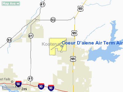
Coeur D'alene Air Term Airport
Address:
Kootenai County, ID
Tel:
208-446-1600, 208-446-1860
Images
and information placed above are from
http://www.airport-data.com/airport/COE/
We
thank them for the data!
| General
Info |
| Country |
United
States |
| State |
IDAHO
|
| FAA ID |
COE |
| Latitude |
47-46-27.450N
|
| Longitude |
116-49-10.643W
|
| Elevation |
2318 feet
|
| Near City |
COEUR
D'ALENE |
We don't guarantee the information is fresh and accurate. The data may
be wrong or outdated.
For more up-to-date information please refer to other sources.
|
|


