 |
|
|
|
Location
& QuickFacts
|
FAA
Information Effective: |
2007-07-05 |
|
Airport
Identifier: |
ID89 |
|
Airport
Status: |
Operational |
|
Longitude/Latitude: |
116-12-21.4250W/43-39-11.6000N
-116.205951/43.653222 (Estimated) |
|
Elevation: |
2890 ft / 880.87 m (Estimated) |
|
Land: |
0 acres |
|
From
nearest city: |
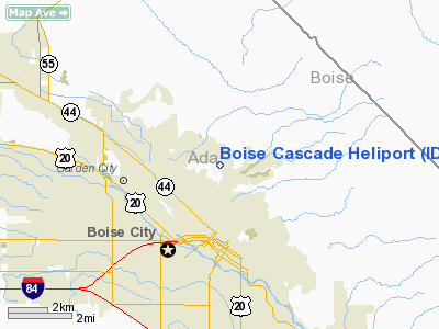
3 nautical miles N of Boise, ID |
|
Location: |
Ada County, ID |
|
Magnetic Variation: |
17E (1985) |
Owner
& Manager
|
Ownership: |
Privately
owned |
|
Owner: |
Boise Cascade |
|
Address: |
1 Jefferson Square
Boise, ID 83721 |
|
Phone
number: |
208-287-1700 |
|
Manager: |
Dave Gardner |
|
Address: |
2081 W Commerce Avenue
Boise, ID 83705 |
|
Phone number: |
208-384-7580 |
Airport Operations and Facilities
|
Airport Use: |
Private |
|
Wind indicator: |
Yes |
|
Segmented Circle: |
No |
|
Control Tower: |
No |
|
Landing fee charge: |
No |
|
Sectional chart: |
Salt Lake City |
|
Region: |
ANM - Northwest Mountain |
|
Boundary ARTCC: |
ZLC - Salt Lake City |
|
Tie-in FSS: |
BOI - Boise |
|
FSS on Airport: |
No |
|
FSS Phone: |
208-332-0200 |
|
FSS Toll Free: |
1-800-WX-BRIEF |
Airport Services
|
Airframe
Repair: |
NONE |
|
Power
Plant Repair: |
NONE |
|
Runway Information
Helipad H1
|
Dimension: |
75
x 40 ft / 22.9 x 12.2 m |
|
Surface: |
CONC, |
|
|
Runway H1 |
Runway |
|
Traffic
Pattern: |
Right |
Left |
|
Radio Navigation
Aids
|
ID |
Type |
Name |
Ch |
Freq |
Var |
Dist |
|
BO |
NDB |
Ustik |
|
359.00 |
17E |
5.8 nm |
|
MPA |
NDB |
Meridian |
|
238.00 |
16E |
14.8 nm |
|
STI |
NDB |
Sturgeon |
|
333.00 |
17E |
40.3 nm |
|
ONO |
NDB |
Ontario |
|
305.00 |
17E |
41.2 nm |
|
MUO |
TACAN |
Mountain Home |
087X |
|
18E |
39.6 nm |
|
LIA |
VOR |
Liberator |
|
114.90 |
18E |
44.5 nm |
|
BOI |
VORTAC |
Boise |
080X |
113.30 |
17E |
6.1 nm |
|
BOI |
VOT |
Boise |
|
116.70 |
|
5.1 nm |
Remarks
Boise Cascade Heliport
Address:
Ada County, ID
Tel:
208-287-1700,
208-384-7580
Images
and information placed above are from
http://www.airport-data.com/airport/ID89/
We
thank them for the data!
| General
Info |
| Country |
United
States |
| State |
IDAHO
|
| FAA ID |
ID89 |
| Latitude |
43-39-11.600N
|
| Longitude |
116-12-21.425W
|
| Elevation |
2890 feet
|
| Near City |
BOISE
|
We don't guarantee the information is fresh and accurate. The data may
be wrong or outdated.
For more up-to-date information please refer to other sources.
|
|


