|
 |
|
||||
|
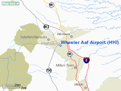
Wheeler Army Airfield (IATA: HHI, ICAO: PHHI, FAA LID: HHI), also known as Wheeler Field and formerly as Wheeler Air Force Base, is a United States Army post located in the City & County of Honolulu and in the Wahiawa District of the Island of O'ahu, Hawaii. It is a National Historic Landmark for its role in the December 7, 1941 Japanese attack on Pearl Harbor. HistorySoldiers from Schofield Barracks began clearing earth to make an aircraft landing strip in February 1922. On Nov. 11 of that year, the resulting airfield was named in honor of Major Sheldon Harley Wheeler, killed in the crash of DH-4B, AS-63525 , on July 12, 1921, and commander of Luke Field on Ford Island at the time of his death. Wheeler Field was the site of several major historic aviation events prior to the attack on Pearl Harbor on 7 December 1941, including the first nonstop Mainland-Hawai'i flight in 1927; the great Dole Air Race from California to Hawai'i; the first trans-Pacific flight from the U.S. to Australia in 1928, and the first Hawai'i-to-Mainland solo flight in 1935 by Amelia Earhart. Ms. Earhart visited Wheeler Field in 1935 in her Lockheed Vega and in 1937 in her Lockheed Model 10 Electra. Kingsford Smith, in his plane, the Southern Cross, also used the airfield on his historic flights across the Pacific. By 1940, Wheeler Field had evolved into a primary base for Army Air Corps pursuit (i.e., "fighter") aircraft such as the P-40 Warhawk, responsible for air defense of the Hawaiian Islands Territory. Wheeler Field continued in this role through World War II, as the Army Air Corps became the Army Air Forces. With the establishment of the U.S. Air Force as a separate service in 1947, Wheeler Field became Wheeler Air Force Base under the operational control of Pacific Air Forces (PACAF). During the 1960s, 1970s and 1980s, the installation hosted a number of Army and Air Force activities, including Army rotary-wing and fixed-wing aviation units and USAF fixed-wing air support / forward air control units flying the O-2 Skymaster and OV-10 Bronco. In August 1987, the Secretary of the Interior designated Wheeler Air Force Base, now Wheeler Army Airfield, a National Historic Landmark, recognizing it as a site of national significance in the history of the United States and in particular, World War II in the Pacific. Wheeler AFB was returned to the Department of the Army on 1 November 1991 and renamed Wheeler Army Airfield. Wheeler AAF comprises approximately 1,389 acres (5.62 km) of land adjacent to Schofield Barracks and home to a variety of Department of Defense activities including the Defense Information Systems Agency (DISA), the 169th Aircraft Control & Warning Squadron (169 ACWS) of the Hawaii Air National Guard, the 193rd Aviation Regiment (Medium Lift) and Det 55 OSA of the Hawaii Army National Guard and the Regular Army's B Company/214th Aviation (Heavy Lift), 68th Medical Company (Air Ambulance), and the 25th Infantry Division's (Light) Aviation Brigade . Attack on Pearl Harbor
Wheeler Army Airfield was a primary target and site of the first attack on 7 December 1941, leading up to the attack on Pearl Harbor. The Japanese attacked the airfield to prevent the numerous planes there from getting airborne and engaging them. The installation has a National Historic Landmark District in association with the attack on 7 December 1941. The 1941 Flightline, hangars and barracks survive today. DesignWheeler Army Airfield was constructed in the pattern of the Garden City. These type of neighborhoods are the inspiration of Sir Ebeneezer Howard of England, who designed these type neighborhoods in re-action to the industrial company towns that had blighted his nation. The neighborhoods are designed in loops with ample green spaces that were to be shared in common among the residents. The homes within the loops are of the Spanish Colonial Revival style that was flourishing in the 1920s and 1930s. Today, Wheeler Army Airfield comprises approximately 1,389 acres (5.6 km²) of land returned to the Department of the Army on Nov. 1, 1991. As of the 2000 Census, the base had a total population of 2,829 military personnel and families. GeographyWheeler AAF is located at 21°28'56" North, 158°2'24" West (21.482216, -158.039959). The Wheeler Main Gate is located on Kamehameha Highway (State Rte 99) running north to Wahiawā (becoming State Rte. 80) and connecting westward to Wilikina Road (State Rte. 99) and Schofield Barracks. Proceeding south on Kamehameha Hwy. provides access to Interstate H-2 and Milillani Town. The Wheeler Kunia Gate is off Kunia Road directly across from the Schofield Lyman Gate. Kunia Road (State Rte. 750) continues south to Kunia, and eventually Waipahu. Wheeler is directly adjacent to Schofield Barracks across Kunia Road and to Wahiawā on the central plateau of the Island of O'ahu. The U.S. postal code for Wheeler Army Airfield is 96786. According to the United States Census Bureau, the base has a total area of 5.9 km² (2.3 mi²). 5.9 km² (2.3 mi²) of it is land and none of it is covered by water. DemographicsAs of the 2000 Census, there were 2,829 people, 739 households, and 724 families residing on the base. The population density was 477.0/km² (1,235.6/mi²). There were 855 housing units at an average density of 144.2/km² (373.4/mi²). The racial makeup of the base was 57.02% White, 21.60% African American, 1.10% Native American, 3.99% Asian, 1.87% Pacific Islander, 6.33% from other races, and 8.09% from two or more races. 13.15% of the population were Hispanic or Latino of any race. There are 739 households out of which 77.9% have children under the age of 18 living with them, 89.7% are married couples living together, 6.4% have a female householder with no husband present, and 2.0% are non-families. 1.9% of all households are made up of individuals and 0.0% have someone living alone who is 65 years of age or older. The average household size is 3.36 and the average family size is 3.38. In the base the population is spread out with 36.8% under the age of 18, 20.9% from 18 to 24, 40.9% from 25 to 44, 1.3% from 45 to 64, and 0.1% who are 65 years of age or older. The median age is 23 years. For every 100 females there are 119.8 males. For every 100 females age 18 and over, there are 127.8 males. The median income for a household in the post is $32,485, and the median income for a family is $32,264. Males have a median income of $22,961 versus $22,151 for females. The per capita income for the post is $12,364. 7.9% of the population and 5.9% of families are below the poverty line. Out of the total population, 9.9% of those under the age of 18 and 0.0% of those 65 and older are living below the poverty line. The above content comes from Wikipedia and is published under free licenses – click here to read more.
Runway InformationRunway 06/24
Radio Navigation Aids
Remarks
Wheeler Aaf Airport Address: Honolulu County, HI Tel: 808-656-2656 Images
and information placed above are from We thank them for the data!
We don't guarantee the information is fresh and accurate. The data may
be wrong or outdated.
|
|||||||||||||||||||||||||||||||||||||||||||||||||||||||||||||||||||||||||||||||||||||||||||||||||||||||||||||||||||||||||||||||||||||||||||||||||||||||||||||||||||||||||||||||||||||||||||||||||||||||||||||||||||||||||||||||||||||||||||||||||||||||||||||||||||||||||||||||||||

 |
|
Copyright 2004-2026 © by Airports-Worldwide.com, Vyshenskoho st. 36, Lviv 79010, Ukraine Legal Disclaimer |
.jpg)