|
|
| Upolu Airport |
| IATA: UPP â ICAO: PHUP â FAA LID: UPP
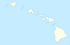
Location of airport in Hawaii
|
| Summary |
| Airport type |
Public |
| Operator |
Hawaii Department of Transportation |
| Serves |
Hawi, Hawaii |
| Elevation AMSL |
96 ft / 29 m |
| Coordinates |
20°15â²55â³N 155°51â²36â³W / 20.26528°N 155.86°W / 20.26528; -155.86 (Upolu Airport)Coordinates: 20°15â²55â³N 155°51â²36â³W / 20.26528°N 155.86°W / 20.26528; -155.86 (Upolu Airport) |
| Website |
hawaii.gov/upp |
| Runways |
| Direction |
Length |
Surface |
| ft |
m |
| 7/25 |
3,800 |
1,158 |
Asphalt |
| Statistics (2008) |
| Aircraft operations |
790 |
| Source: Federal Aviation Administration |
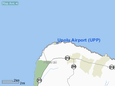
Upolu Airport (IATA: UPP, ICAO: PHUP, FAA LID: UPP) is a regional airport of the State of Hawai'i in Hawai'i County. Located on the northern tip of the Big Island, Upolu Airport is 3 NM (5.6 km; 3.5 mi) northwest of the unincorporated town of Hawi. Facilities and aircraft
As a general aviation airport, Upolu Airport has a single runway without taxiways and two aircraft parking areas south of the runway. The east parking area supports passenger terminal operations and the west parking area provides tie down facilities for general aviation aircraft. The airport does not have a control tower, aircraft rescue and fire fighting facilities, or discrete air cargo facilities. Access to the airport is provided by a roadway off Akoni Pule Highway. In the event of increased air traffic, the Hawai'i State Legislature has made preliminary plans to build a parallel taxiway south of the runway and move the existing terminal facilities farther from the runway to provide improved clearances and additional aircraft parking.
Upolu Airport covers an area of 82 acres (33 ha) at an elevation of 96 feet (29 m) above mean sea level. It has one runway designated 7/25 with an asphalt surface measuring 3,800 by 75 feet (1,158 x 23 m). For the 12-month period ending December 31, 2008, the airport had 790 aircraft operations, an average of 65 per month: 89% general aviation, 10% military, and 1% air taxi.
Authority
Upolu Airport is part of a centralized state structure governing all of the airports and seaports of Hawai'i. The official authority of Upolu Airport is the Governor of Hawai'i. He or she appoints the Director of the Hawai'i State Department of Transportation who has jurisdiction over the Hawai'i Airports Administrator.
The Hawai'i Airports Administrator oversees six governing bodies: Airports Operations Office, Airports Planning Office, Engineering Branch, Information Technology Office, Staff Services Office, Visitor Information Program Office. Collectively, the six bodies have authority over the four airport districts in Hawai'i: Hawai'i District, Kaua'i District, Mau'i District and the principal O'ahu District. Upolu Airport is a subordinate of the Hawai'i District officials.
The above content comes from Wikipedia and is published under free licenses – click here to read more.
Location
& QuickFacts
|
FAA Information Effective: |
2007-07-05 |
|
Airport
Identifier: |
UPP |
|
Airport
Status: |
Operational |
|
Longitude/Latitude: |
155-51-35.9550W/20-15-54.9210N
-155.859987/20.265256 (Estimated) |
|
Elevation: |
96
ft / 29.26 m (Estimated) |
|
Land: |
82
acres |
|
From
nearest city: |
3 nautical miles NW of Hawi, HI |
|
Location: |
Hawaii County, HI |
|
Magnetic Variation: |
11E (1980) |
Owner
& Manager
|
Ownership: |
Publicly owned |
|
Owner: |
State Of Hawaii Airports Division |
|
Address: |
400 Rodgers Blvd Suite 700
Honolulu, HI 96819 |
|
Phone
number: |
808-838-8701 |
|
Manager: |
Chauncey Wong Yeun
MYRON SHIMAMOTO MAINT. PHONE WAIMEA-KOHALA 808-885-4520. |
|
Address: |
73-200 Kupipi Street
Kailua-kona, HI 96740-2645 |
|
Phone number: |
808-327-9520 |
Airport
Operations and Facilities
|
Airport Use: |
Open to public |
|
Wind
indicator: |
Yes |
|
Segmented
Circle: |
Yes |
|
Control
Tower: |
No |
|
Lighting
Schedule: |
DUSK-DAWN
ACTVT MIRL RY 07/25 PAPI RYS 07 & 25 - CTAF. |
|
Beacon
Color: |
Clear-Green (lighted land airport) |
|
Landing
fee charge: |
No |
|
Sectional
chart: |
Hawaiian Islands |
|
Region: |
AWP - Western-Pacific |
|
Boundary
ARTCC: |
ZHN - Honolulu Control Facility |
|
Tie-in
FSS: |
HNL - Honolulu |
|
FSS
on Airport: |
No |
|
FSS
Phone: |
808-836-8049 |
|
FSS
Toll Free: |
1-800-WX-BRIEF |
|
NOTAMs
Facility: |
UPP (NOTAM-d service avaliable) |
|
Federal Agreements: |
NGY3 |
Airport
Communications
Airport
Services
|
Airframe Repair: |
NONE |
|
Power Plant Repair: |
NONE |
|
Bottled
Oxygen: |
NONE |
|
Bulk
Oxygen: |
NONE |
|
Runway Information
Runway 07/25
|
Dimension: |
3800 x 75 ft / 1158.2 x 22.9 m |
|
Surface: |
ASPH, Good Condition |
|
Weight
Limit: |
Single wheel: 30000 lbs. |
|
Edge
Lights: |
Medium |
|
|
Runway 07 |
Runway 25 |
|
Elevation: |
90.00
ft |
77.00
ft |
|
Traffic
Pattern: |
Left |
Right |
|
Markings: |
Basic, Fair Condition |
Basic, Fair Condition |
|
Crossing
Height: |
29.00
ft |
32.00
ft |
|
VASI: |
2-light PAPI on left side |
2-light PAPI on left side |
|
Visual
Glide Angle: |
3.00° |
3.00° |
|
Runway
End Identifier: |
No |
No |
|
Centerline
Lights: |
No |
No |
|
Touchdown
Lights: |
No |
No |
|
Obstruction: |
, 50:1 slope to clear |
25 ft hill, 500.0 ft from runway, 120 ft left
of centerline, 12:1 slope to clear |
|
Radio Navigation
Aids
|
ID |
Type |
Name |
Ch |
Freq |
Var |
Dist |
|
BSF |
NDB |
Bradshaw |
|
339.00 |
10E |
33.7 nm |
|
VYI |
NDB |
Valley Island |
|
327.00 |
11E |
49.4 nm |
|
MUE |
VOR/DME |
Kamuela |
080X |
113.30 |
11E |
19.3 nm |
|
UPP |
VORTAC |
Upolu Point |
070X |
112.30 |
11E |
4.0 nm |
|
IAI |
VORTAC |
Kona |
104X |
115.70 |
11E |
37.9 nm |
|
OGG |
VORTAC |
Maui |
098X |
115.10 |
11E |
49.8 nm |
Remarks
- < 1500? ACFT LARGE MSL. 800? SMALL>
- PPR
FOR TRANSIENT PARKING.
- PPR
FM ARPT MGR PHONE (808)329-2484 FOR TRANSPORTATION OF CLASS A &
B EXPLOSIVES IN OR OUT OF AIRPORT.
- ALL
HELICOPTERS CONFINE OPNS TO PAVED AREAS ONLY.
- OCCASIONAL
FLOCKS OF BIRDS ON AND INVOF ARPT.
Based
Aircraft
|
Aircraft
based on field: |
1 |
|
Single
Engine Airplanes: |
1 |
Operational Statistics
Time Period: 2004-01-02
- 2004-12-31
|
Aircraft
Operations: |
15/Week |
|
Air Taxi: |
1.3% |
|
General
Aviation Local: |
39.0% |
|
General
Aviation Itinerant: |
51.9% |
|
Military: |
7.8% |
Upolu Airport
Address:
Hawaii County, HI
Tel:
808-838-8701,
808-327-9520
Images
and information placed above are from
http://www.airport-data.com/airport/UPP/
We
thank them for the data!
| General
Info |
| Country |
United
States |
| State |
HAWAII
|
| FAA ID |
UPP
|
| Latitude |
20-15-54.921N
|
| Longitude |
155-51-35.955W
|
| Elevation |
96 feet
|
| Near City |
HAWI
|
We don't guarantee the information is fresh and accurate. The data may
be wrong or outdated.
For more up-to-date information please refer to other sources.
|
|