 |
|
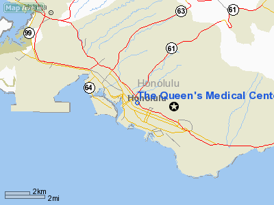
The Queen's Medical Center Heliport |
|
|
Location
& QuickFacts
|
FAA Information Effective: |
2007-07-05 |
|
Airport
Identifier: |
HI38 |
|
Airport
Status: |
Operational |
|
Longitude/Latitude: |
157-51-10.7270W/21-18-33.0070N
-157.852980/21.309169 (Estimated) |
|
Elevation: |
102 ft / 31.09 m (Estimated) |
|
Land: |
0
acres |
|
From
nearest city: |
0 nautical miles N of Honolulu, HI |
|
Location: |
Honolulu County, HI |
|
Magnetic Variation: |
11E (1985) |
Owner
& Manager
|
Ownership: |
Privately owned |
|
Owner: |
The Queen's Medical Center |
|
Address: |
1301 Punchbowl St
Honolulu, HI 96813 |
|
Phone number: |
808-547-4509 |
|
Manager: |
Gary Dias |
|
Address: |
1301 Punchbowl St
Honolulu, HI 96813 |
|
Phone number: |
808-547-4509 |
Airport
Operations and Facilities
|
Airport Use: |
Private |
|
Wind
indicator: |
Yes |
|
Segmented
Circle: |
No |
|
Control
Tower: |
No |
|
Lighting
Schedule: |
PHONE REQ
FOR PERIMETER LGTS CALL 808-547-4311. |
|
Landing
fee charge: |
No |
|
Sectional
chart: |
Hawaiian Islands |
|
Region: |
AWP - Western-Pacific |
|
Boundary
ARTCC: |
ZHN - Honolulu Control Facility |
|
Tie-in
FSS: |
HNL - Honolulu |
|
FSS
on Airport: |
No |
|
FSS
Phone: |
808-836-8049 |
|
FSS
Toll Free: |
1-800-WX-BRIEF |
|
Runway Information
Helipad H1
|
Dimension: |
61 x 63 ft / 18.6 x 19.2 m |
|
Surface: |
CONC, |
|
|
Runway H1 |
Runway |
|
Traffic
Pattern: |
Left |
Left |
|
Radio Navigation
Aids
|
ID |
Type |
Name |
Ch |
Freq |
Var |
Dist |
|
HN |
NDB |
Ewabe |
|
242.00 |
11E |
11.0 nm |
|
HHI |
NDB |
Wheeler |
|
373.00 |
11E |
14.3 nm |
|
NGF |
TACAN |
Kaneohe Bay |
093X |
|
11E |
9.9 nm |
|
HNL |
VORTAC |
Honolulu |
095X |
114.80 |
11E |
4.3 nm |
|
CKH |
VORTAC |
Koko Head |
086X |
113.90 |
11E |
8.8 nm |
|
MKK |
VORTAC |
Molokai |
108X |
116.10 |
11E |
39.8 nm |
|
HNL |
VOT |
Honolulu |
|
111.00 |
|
4.5 nm |
Remarks
- PRVDD
OPNS CONDUCTED IN VFR CONDS & THAT THE PAUAHI ELEVATOR SHAFT BE
OBSTN LGTD.
The Queen's Medical Center Heliport
Address:
Honolulu County, HI
Tel:
808-547-4509
Images
and information placed above are from
http://www.airport-data.com/airport/HI38/
We
thank them for the data!
| General
Info |
| Country |
United
States |
| State |
HAWAII
|
| FAA ID |
HI38
|
| Latitude |
21-18-33.007N
|
| Longitude |
157-51-10.727W
|
| Elevation |
102 feet
|
| Near City |
HONOLULU
|
We don't guarantee the information is fresh and accurate. The data may
be wrong or outdated.
For more up-to-date information please refer to other sources.
|
|


