 |
|
Pepeekeo Airstrip Airport |
|
|
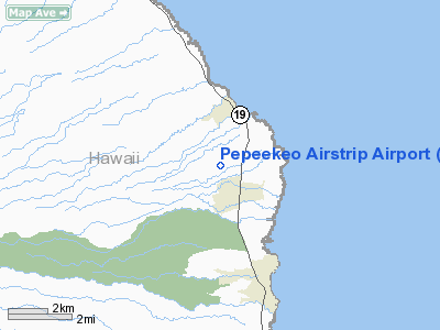
Location
& QuickFacts
|
FAA Information Effective: |
2007-07-05 |
|
Airport
Identifier: |
HI32 |
|
Airport
Status: |
Operational |
|
Longitude/Latitude: |
155-06-48.0330W/19-50-41.0350N
-155.113343/19.844732 (Estimated) |
|
Elevation: |
675 ft / 205.74 m (Estimated) |
|
Land: |
0
acres |
|
From
nearest city: |
2 nautical miles W of Pepeekeo, HI |
|
Location: |
Hawaii County, HI |
|
Magnetic Variation: |
11E (1985) |
Owner
& Manager
|
Ownership: |
Privately owned |
|
Owner: |
Mauna Kea Agribusiness Co.
INC. |
|
Address: |
Po Box 18
Pepeekeo, HI 96783 |
|
Phone number: |
808-964-1011 |
|
Manager: |
John C Cross |
|
Address: |
Po Box 18
Pepeekeo, HI 96783 |
|
Phone number: |
808-964-1011 |
Airport
Operations and Facilities
|
Airport Use: |
Private |
|
Wind indicator: |
No |
|
Segmented Circle: |
No |
|
Control Tower: |
No |
|
Landing fee charge: |
No |
|
Sectional chart: |
Hawaiian Islands |
|
Region: |
AWP - Western-Pacific |
|
Boundary ARTCC: |
ZHN - Honolulu Control Facility |
|
Tie-in FSS: |
HNL - Honolulu |
|
FSS on Airport: |
No |
|
FSS Phone: |
808-836-8049 |
|
FSS Toll Free: |
1-800-WX-BRIEF |
Airport
Services
|
Airframe Repair: |
NONE |
|
Power Plant Repair: |
NONE |
|
Runway
Information
Runway NE/SW
|
Dimension: |
2000 x 25 ft / 609.6 x 7.6 m |
|
Surface: |
ASPH,
200' OVRN NE END RWY NE/SW. |
|
|
Runway NE |
Runway SW |
|
Traffic
Pattern: |
Left |
Left |
|
Obstruction: |
15 ft cane, 100.0 ft from runway |
|
|
Radio Navigation
Aids
|
ID |
Type |
Name |
Ch |
Freq |
Var |
Dist |
|
POA |
NDB |
Pahoa |
|
332.00 |
11E |
19.9 nm |
|
BSF |
NDB |
Bradshaw |
|
339.00 |
10E |
27.6 nm |
|
MUE |
VOR/DME |
Kamuela |
080X |
113.30 |
11E |
32.8 nm |
|
ITO |
VORTAC |
Hilo |
116X |
116.90 |
11E |
9.4 nm |
|
UPP |
VORTAC |
Upolu Point |
070X |
112.30 |
11E |
46.4 nm |
Remarks
- SUGAR
CANE SURROUNDS AIRPORT WITH MACADAMIA NUT TREES ON THE SOUTHEAST.
- OWNER
DESIRES ARPT NOT BE CHARTED.
Pepeekeo Airstrip Airport
Address:
Hawaii County, HI
Tel:
808-964-1011
Images
and information placed above are from
http://www.airport-data.com/airport/HI32/
We
thank them for the data!
| General
Info |
| Country |
United
States |
| State |
HAWAII
|
| FAA ID |
HI32
|
| Latitude |
19-50-41.035N
|
| Longitude |
155-06-48.033W
|
| Elevation |
675 feet
|
| Near City |
PEPEEKEO
|
We don't guarantee the information is fresh and accurate. The data may
be wrong or outdated.
For more up-to-date information please refer to other sources.
|
|


