|
|
| Molokai Airport |
 |
| IATA: MKK â ICAO: PHMK â FAA LID: MKK |
| Summary |
| Airport type |
Public |
| Operator |
Hawaii Department of Transportation |
| Serves |
Kaunakakai, Hawaii |
| Elevation AMSL |
454 ft / 138 m |
| Coordinates |
21°09â²10â³N 157°05â²47â³W / 21.15278°N 157.09639°W / 21.15278; -157.09639 (Molokai Airport)Coordinates: 21°09â²10â³N 157°05â²47â³W / 21.15278°N 157.09639°W / 21.15278; -157.09639 (Molokai Airport) |
| Website |
hawaii.gov/mkk |
| Runways |
| Direction |
Length |
Surface |
| ft |
m |
| 5/23 |
4,494 |
1,370 |
Asphalt |
| 17/35 |
3,118 |
950 |
Asphalt |
| Statistics (2010) |
| Aircraft operations |
40,716 |
| Based aircraft |
4 |
| Source: Federal Aviation Administration |
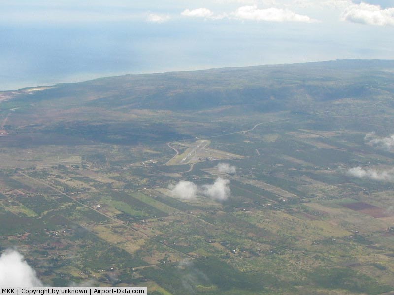
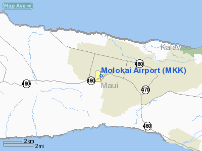
Molokai Airport (IATA: MKK, ICAO: PHMK, FAA LID: MKK) is a public airport located 6 NM (11 km; 6.9 mi) northwest of Kaunakakai, on the island of Molokai in Maui County, Hawaii, United States. It is the principal airport of the island. Facilities and aircraft
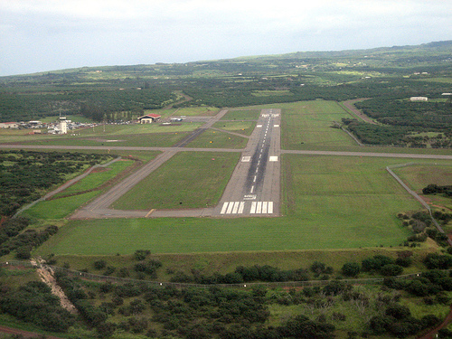
Molokai Airport occupies 288 acres (117 ha) at an elevation of 454 feet (138 m) above mean sea level on the central plateau of the island of Molokai. The airport has two asphalt paved runways that accommodate commuter/air taxi and general aviation activities, as well as some military flights: Runway 5/23 is 4,494 by 100 feet (1,370 x 30 m) and Runway 17/35 is 3,118 by 100 feet (950 x 30 m).
The passenger terminal complex and general aviation facilities are north of the runway intersection; the passenger terminal complex is near the principal runway and the general aviation facilities are near the crosswind runway. Vehicular access to these two areas is provided by separate access roadways, each connecting with Keonelele Avenue.
For the 12-month period ending April 20, 2010, the airport had 40,716 aircraft operations, an average of 111 per day: 66% air taxi, 28% general aviation, 4% military, and 2% scheduled commercial. At that time there were 4 aircraft based at this airport, all single-engine.
Airlines and destinations
| Airlines |
Destinations |
| Mokulele Airlines |
Honolulu, Kahului, Kona |
| Island Air |
Honolulu, Kahului, Kapalua |
Disasters
Aloha Island Air Flight 1712
On October 28, 1989, Aloha Island Air flight 1712, a de Havilland Canada DHC-6 Twin Otter aircraft, collided with mountainous terrain near Halawa Valley, Molokai, while en route on a scheduled passenger flight from Kahului Airport to Molokai Airport in Hoolehua.
The NTSB determined the cause of the accident was the airplanes controlled flight into terrain as a result of the decision of the captain to continue the flight under visual flight rules at night into instrument meteorological conditions, which obscured rising mountainous terrain.
All 20 aboard the aircraft died. Thirteen of the victims were from Molokai, including eight members of the Molokai High School boys and girls volleyball teams and two faculty members. The girls team had just qualified on Maui for the state tournament.
Media appearances
The mission "Hawaiian Checkout" supplied with Microsoft Flight Simulator X begins at Molokai Airport.
The above content comes from Wikipedia and is published under free licenses – click here to read more.
|
 |
(Click on the photo to enlarge) |
Location
& QuickFacts
|
FAA Information Effective: |
2007-07-05 |
|
Airport
Identifier: |
MKK |
|
Airport
Status: |
Operational |
|
Longitude/Latitude: |
157-05-46.5220W/21-09-10.3890N
-157.096256/21.152886 (Estimated) |
|
Elevation: |
454 ft / 138.38 m (Surveyed) |
|
Land: |
288 acres |
|
From
nearest city: |
6 nautical miles NW of Kaunakakai, HI |
|
Location: |
Maui County, HI |
|
Magnetic Variation: |
11E (1980) |
Owner
& Manager
|
Ownership: |
Publicly owned |
|
Owner: |
Hawaii State Airports Div |
|
Address: |
Honolulu Intl Arpt
Honolulu, HI 96819 |
|
Phone
number: |
808-836-6432 |
|
Manager: |
James Davis
ARPT OPNS/MAINT MAN/AOM/ MR. CARL BRITO ; PHONE MOLOKAI
567-6140. |
|
Address: |
Kahului Arpt
Kahului, HI 96732 |
|
Phone number: |
808-872-3808 |
Airport
Operations and Facilities
|
Airport Use: |
Open to public |
|
Wind
indicator: |
Yes |
|
Segmented
Circle: |
Yes |
|
Control
Tower: |
Yes |
|
Lighting
Schedule: |
DUSK-DAWN
WHEN ATCT CLSD ACTVT MIRL RY 05/23 AND RY 17/35, REIL RY
05 - CTAF.
PAPI RY 05 OPERATIONAL DAYLIGHT HOURS ONLY. |
|
Beacon
Color: |
Clear-Green (lighted land airport) |
|
Landing
fee charge: |
No |
|
Sectional
chart: |
Hawaiian Islands |
|
Region: |
AWP - Western-Pacific |
|
Boundary
ARTCC: |
ZHN - Honolulu Control Facility |
|
Tie-in
FSS: |
HNL - Honolulu |
|
FSS
on Airport: |
No |
|
FSS
Phone: |
808-836-8049 |
|
FSS
Toll Free: |
1-800-WX-BRIEF |
|
NOTAMs
Facility: |
MKK (NOTAM-d service avaliable) |
|
Certification
type/date: |
I A S 05/1973
ARPT CLSD TO ACR OPNS WITH MORE THAN 10 PSGR SEATS MON-SUN
1930-0600 EXCP PPR CALL 808-567-6140/6008. |
|
Federal Agreements: |
NGY3 |
Airport
Communications
|
Runway Information
Runway 05/23
|
Dimension: |
4494 x 100 ft / 1369.8 x 30.5 m |
|
Surface: |
ASPH, Good Condition |
|
Surface
Treatment: |
Saw-cut or plastic Grooved |
|
Weight
Limit: |
Single wheel: 30000 lbs.
Dual wheel: 48000 lbs. |
|
Edge
Lights: |
Medium |
|
|
Runway 05 |
Runway 23 |
|
Longitude: |
157-06-03.8650W |
157-05-22.5790W |
|
Latitude: |
21-08-58.6840N |
21-09-20.6660N |
|
Elevation: |
437.00
ft |
454.00
ft |
|
Alignment: |
60 |
127 |
|
Traffic
Pattern: |
Left |
Left |
|
Markings: |
Non-precision instrument, Good Condition |
Non-precision instrument, Good Condition |
|
Crossing
Height: |
25.00
ft |
0.00 ft |
|
Displaced
threshold: |
0.00 ft |
593.00
ft |
|
VASI: |
4-light PAPI on left side
PAPI NOT AUTHORIZED 1.8 NM BYD LDG THLD DUE TO RAPIDLY RISING
TERRAIN. |
|
|
Visual
Glide Angle: |
3.00° |
0.00° |
|
Runway
End Identifier: |
Yes |
No |
|
Centerline
Lights: |
No |
No |
|
Touchdown
Lights: |
No |
No |
|
Obstruction: |
, 50:1 slope to clear |
23 ft brush, 400.0 ft from runway, 17:1 slope
to clear
APCH RATIO FROM DSPLCD THLD 23:1. |
|
Runway 17/35
|
Dimension: |
3118 x 100 ft / 950.4 x 30.5 m |
|
Surface: |
ASPH, Fair Condition |
|
Weight
Limit: |
Single wheel: 13000 lbs. |
|
Edge
Lights: |
Medium |
|
|
Runway 17 |
Runway 35 |
|
Longitude: |
157-05-51.2680W |
157-05-51.2860W |
|
Latitude: |
21-09-26.8680N |
21-08-55.9690N |
|
Elevation: |
448.00
ft |
430.00
ft |
|
Alignment: |
127 |
0 |
|
Traffic
Pattern: |
Left |
Left |
|
Markings: |
Basic, Good Condition |
Basic, Good Condition |
|
Displaced
threshold: |
426.00
ft |
0.00 ft |
|
Runway
End Identifier: |
No |
No |
|
Centerline
Lights: |
No |
No |
|
Touchdown
Lights: |
No |
No |
|
Obstruction: |
12 ft fence, 80.0 ft from runway
APCH RATIO 23:1 FROM DSPLCD THLD. |
4 ft fence, 248.0 ft from runway, 12:1 slope
to clear |
|
Radio Navigation
Aids
|
ID |
Type |
Name |
Ch |
Freq |
Var |
Dist |
|
LLD |
NDB |
Lanai |
|
353.00 |
11E |
23.9 nm |
|
VYI |
NDB |
Valley Island |
|
327.00 |
11E |
40.2 nm |
|
NGF |
TACAN |
Kaneohe Bay |
093X |
|
11E |
41.4 nm |
|
MKK |
VORTAC |
Molokai |
108X |
116.10 |
11E |
4.1 nm |
|
LNY |
VORTAC |
Lanai |
124X |
117.70 |
11E |
24.4 nm |
|
CKH |
VORTAC |
Koko Head |
086X |
113.90 |
11E |
34.7 nm |
|
OGG |
VORTAC |
Maui |
098X |
115.10 |
11E |
40.7 nm |
|
HNL |
VORTAC |
Honolulu |
095X |
114.80 |
11E |
47.7 nm |
|
HNL |
VOT |
Honolulu |
|
111.00 |
|
47.9 nm |
Remarks
- 24
HRS PPR FOR CLASS A AND B EXPLOSIVES AND 4 HRS PPR FOR OTHER HAZARDOUS
MATERIAL IN/OUT OF ARPT CTC 808-567-6140/6008.
- MTN
APPROXIMATELY 1280' MSL LCTD 2.8 NM FROM RWY 05 THR ON CNTRLN EXTDD.
- CAUTION:
EGRETS AND PIGEONS ON & INVOF ARPT.
- LARGE
ACFT WITH WINGSPAN GREATER THAN 78 FT MAY NOT USE TWY A OR RY 05/23
FOR SIMULTANEOUS OPNS.
Based Aircraft
|
Aircraft
based on field: |
4 |
|
Single
Engine Airplanes: |
4 |
Operational Statistics
Time Period: 2006-01-01
- 2006-12-31
|
Aircraft
Operations: |
112/Day |
|
Commerical: |
1.7% |
|
Air Taxi: |
65.8% |
|
General
Aviation Local: |
6.1% |
|
General
Aviation Itinerant: |
22.2% |
|
Military: |
4.1% |
Molokai Airport
Address:
Maui County, HI
Tel:
808-836-6432,
808-872-3808
Images
and information placed above are from
http://www.airport-data.com/airport/MKK/
We
thank them for the data!
| General
Info |
| Country |
United
States |
| State |
HAWAII
|
| FAA ID |
MKK
|
| Latitude |
21-09-10.389N
|
| Longitude |
157-05-46.522W
|
| Elevation |
454 feet
|
| Near City |
KAUNAKAKAI
|
We don't guarantee the information is fresh and accurate. The data may
be wrong or outdated.
For more up-to-date information please refer to other sources.
|
|