|
|
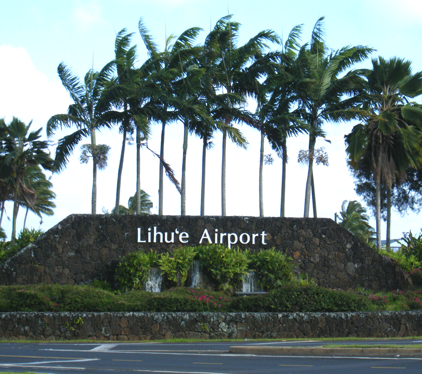
| Lihue Airport |
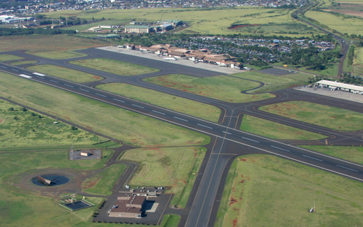 |
| Runway 3-21 and the passenger terminal in background; fire station in foreground. |
| IATA: LIH â ICAO: PHLI â FAA LID: LIH
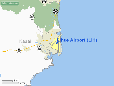
Location of the Lihue Airport
|
| Summary |
| Airport type |
Public |
| Owner |
State of Hawaii |
| Operator |
Department of Transportation |
| Serves |
Lihue, Hawaii |
| Elevation AMSL |
153 ft / 47 m |
| Coordinates |
21°58â²34â³N 159°20â²20â³W / 21.97611°N 159.33889°W / 21.97611; -159.33889 |
| Website |
http://hawaii.gov/lih |
| Runways |
| Direction |
Length |
Surface |
| ft |
m |
| 3/21 |
6,500 |
1,981 |
Asphalt |
| 17/35 |
6,500 |
1,981 |
Asphalt |
| Helipads |
| Number |
Length |
Surface |
| ft |
m |
| H1 |
64 |
20 |
Asphalt |
| Statistics (2005) |
| Aircraft operations |
104,276 |
| Based aircraft |
28 |
| Source: Federal Aviation Administration |
Lihue Airport (IATA: LIH, ICAO: PHLI, FAA LID: LIH) is a state-owned public-use airport located in the Līhuʻe CDP on the southeast coast of the island of Kauaʻi in Kauai County, Hawaiʻi, United States, two nautical miles east of the center of the CDP.
The airport does not serve as a hub for any airline carrier. Numerous inter-island flights are available daily. During the 1970âs, United Airlines used Douglas DC-8's between Los Angeles and Lihue. American Airlines, Delta Air Lines, United Airlines and US Airways all utilize Boeing 757-200âs between Lihue and their mainland destinations. Alaska Airlines and WestJet utilize Next Generation Boeing 737-800âs between Lihue and their mainland destinations; while Hawaiian Airlines uses Boeing 717-200âs between Lihue and Honolulu. The airport's runway can handle planes up to and including the size of a DC-10. The airport is mostly un-walled, and the check in is completely outside.
The airport is the primary gateway to Kauai for visitors (especially tourists), and has several rental car facilities. Two movies have filmed scenes at the Lihue Airport. "Honeymoon in Vegas" and "Six Days Seven Nights". Facilities and aircraft
Lihue Airport covers an area of 879 acres (356 ha) at an elevation of 153 feet (47 m) above mean sea level. It has two asphalt paved runways designated 3/21 and 17/35, each measuring 6,500 by 150 feet (1,981 x 46 m). The airport also has one helipad measuring 64 by 64 feet (20 x 20 m).
For the 12-month period ending May 31, 2005, the airport had 104,276 aircraft operations, an average of 285 per day: 48% air taxi, 26% scheduled commercial, 23% general aviation and 2% military. At that time there were 28 aircraft based at this airport: 43% single-engine, 7% multi-engine and 50% helicopter.
Airlines and destinations
| Airlines |
Destinations |
| Alaska Airlines |
Oakland [begins March 28], San Jose (CA) [begins March 27], Seattle/Tacoma |
| American Airlines |
Los Angeles |
| Delta Air Lines |
Los Angeles |
| Hawaiian Airlines |
Honolulu |
| Island Air |
Honolulu, Kahului |
| go! Mokulele operated by Mesa Airlines |
Honolulu |
| United Airlines |
Denver [seasonal], Los Angeles, San Francisco |
| US Airways |
Phoenix |
| WestJet |
Vancouver [seasonal] |
The above content comes from Wikipedia and is published under free licenses – click here to read more.
Location
& QuickFacts
|
FAA Information Effective: |
2007-07-05 |
|
Airport
Identifier: |
LIH |
|
Airport
Status: |
Operational |
|
Longitude/Latitude: |
159-20-20.2487W/21-58-33.5389N
-159.338958/21.975983 (Estimated) |
|
Elevation: |
153 ft / 46.63 m (Surveyed) |
|
Land: |
879 acres |
|
From
nearest city: |
2 nautical miles E of Lihue, HI |
|
Location: |
Kauai County, HI |
|
Magnetic Variation: |
11E (1990) |
Owner
& Manager
|
Ownership: |
Publicly owned
DIST. MGR; STATE OF HAWAII DEPT. OF TRANSPORTATION AIRPORTS DIV. |
|
Owner: |
Hawaii St Arpts Div |
|
Address: |
Honolulu Intl Arpt
Honolulu, HI 96819 |
|
Phone
number: |
808-838-8600 |
|
Manager: |
Tim Skinner |
|
Address: |
3901 Mokulele Lp Box 6
Lihue, HI 96766 |
|
Phone number: |
808-246-1400 |
Airport
Operations and Facilities
|
Airport Use: |
Open to public |
|
Wind
indicator: |
Yes |
|
Segmented
Circle: |
Yes |
|
Control
Tower: |
Yes |
|
Lighting
Schedule: |
DUSK-DAWN
ACTVT HIRL RY 17/35; REIL RY 17; MALSR RY 35; MIRL RY 03/21;
REIL & PAPI RY 03; REIL RY 21 & TWY LGTS - CTAF. |
|
Beacon
Color: |
Clear-Green (lighted land airport) |
|
Landing
fee charge: |
No |
|
Sectional
chart: |
Hawaiian Islands |
|
Region: |
AWP - Western-Pacific |
|
Boundary
ARTCC: |
ZHN - Honolulu Control Facility |
|
Tie-in
FSS: |
HNL - Honolulu |
|
FSS
on Airport: |
No |
|
FSS
Phone: |
808-836-8049 |
|
FSS
Toll Free: |
1-800-WX-BRIEF |
|
NOTAMs
Facility: |
LIH (NOTAM-d service avaliable) |
|
Certification
type/date: |
I C S 05/1973
< 24 AVBL EQUIPMENT
FIRE &> |
|
Federal Agreements: |
NGY |
Airport
Communications
Airport
Services
|
Fuel available: |
100 A
100 OCTANE FUEL AVBL 0900-1700. FOR JET A FUEL CALL 1-800-776-2138
OR 1-800-821-3122. |
|
Airframe Repair: |
MINOR |
|
Power Plant Repair: |
MINOR
HELI MAJOR. |
|
Bottled
Oxygen: |
NONE |
|
Bulk
Oxygen: |
NONE |
|
Runway Information
Runway 03/21
|
Dimension: |
6500
x 150 ft / 1981.2 x 45.7 m
DISTANCE REMAINING SIGNS LEFT SIDE |
|
Surface: |
ASPH, Good Condition |
|
Surface
Treatment: |
Saw-cut or plastic Grooved |
|
Weight
Limit: |
Single wheel: 75000 lbs.
Dual wheel: 200000 lbs.
Dual tandem wheel: 350000 lbs.
Dual dual tandem wheel: 730000 lbs. |
|
Edge
Lights: |
Medium |
|
|
Runway 03 |
Runway 21 |
|
Longitude: |
159-20-55.7446W |
159-20-06.9071W |
|
Latitude: |
21-58-22.4566N |
21-59-07.9956N |
|
Elevation: |
152.00
ft |
80.00
ft |
|
Alignment: |
45 |
127 |
|
Traffic
Pattern: |
Right |
Left |
|
Markings: |
Non-precision instrument, Good Condition |
Non-precision instrument, Good Condition |
|
Crossing
Height: |
46.00
ft |
52.00
ft |
|
Displaced
threshold: |
0.00 ft |
205.00
ft |
|
VASI: |
4-light PAPI on left side
PAPI UNUSBL BYD 1.5 NM & OFFSET 9.5 DEGREES EAST OF CNTRLN
DUE TO RAPIDLY RISING TERRAIN. |
4-box on left side |
|
Visual
Glide Angle: |
3.00° |
3.00° |
|
Runway
End Identifier: |
Yes |
Yes |
|
Centerline
Lights: |
No |
No |
|
Touchdown
Lights: |
No |
No |
|
Obstruction: |
, 50:1 slope to clear |
4 ft tree, 200.0 ft from runway, 100 ft right
of centerline, 50:1 slope to clear |
|
Runway 17/35
|
Dimension: |
6500
x 150 ft / 1981.2 x 45.7 m
DISTANCE REMAINING SIGNS LEFT SIDE |
|
Surface: |
ASPH, Good Condition |
|
Surface
Treatment: |
Saw-cut or plastic Grooved |
|
Weight
Limit: |
Single wheel: 75000 lbs.
Dual wheel: 175000 lbs.
Dual tandem wheel: 250000 lbs.
Dual dual tandem wheel: 630000 lbs. |
|
Edge
Lights: |
High |
|
|
Runway 17 |
Runway 35 |
|
Longitude: |
159-20-09.1636W |
159-20-09.1760W |
|
Latitude: |
21-58-54.0554N |
21-57-49.6456N |
|
Elevation: |
92.00
ft |
92.00
ft |
|
Alignment: |
127 |
0 |
|
ILS
Type: |
|
ILS/DME |
|
Traffic
Pattern: |
Left |
Right |
|
Markings: |
Precision instrument, Good Condition |
Precision instrument, Good Condition |
|
Crossing
Height: |
55.00
ft |
55.00
ft |
|
VASI: |
4-light PAPI on left side |
4-light PAPI on left side |
|
Visual
Glide Angle: |
3.00° |
3.00° |
|
Approach
lights: |
|
MALSR |
|
Runway
End Identifier: |
Yes |
|
|
Helipad H1
|
Dimension: |
64
x 64 ft / 19.5 x 19.5 m
DISTANCE REMAINING SIGNS LEFT SIDE |
|
Surface: |
ASPH, Good Condition |
|
|
Runway H1 |
Runway |
|
Traffic
Pattern: |
Left |
Left |
|
Runway
End Identifier: |
No |
|
|
Centerline
Lights: |
No |
|
|
Touchdown
Lights: |
No |
|
|
Radio Navigation
Aids
|
ID |
Type |
Name |
Ch |
Freq |
Var |
Dist |
|
NBS |
TACAN |
Barking Sands Pmrf |
073X |
|
12E |
25.1 nm |
|
LIH |
VORTAC |
Lihue |
082X |
113.50 |
11E |
0.6 nm |
|
SOK |
VORTAC |
South Kauai |
101X |
115.40 |
11E |
11.5 nm |
Remarks
- STADIUM
FLOOD LIGHTS 125' AGL/282' MSL/ 2400' SW FROM RWY 03 THR.
- RY
17/35 WGT LIMIT DC10-10 340000 LBS; DC10-30 430000 LBS.
- ACFT
NEEDING ENGINE RUN-UPS FOR MAINT OR REASONS OTHER THAN START UP FOR
TAXI-IN/OUT AND TKOF/LNDG REQUIRED TO CTC ATCT ON GND FREQ 121.9 FOR
INSTRUCTIONS ON WHERE TO RELOCATE TO PERFORM THESE ENGINE RUNS.
- PPR
FOR PARKING TSNT ACFT WITH PARKING ACCESS TO PSGR/CARGO GATES/FACILITIES
BTN 2200-0600; ANY GROUP OF 3+ ACFT OPER IN CONSORT CALL 246-1400/1462
OR WRITE AMGR FOR PARKING ARRANGEMENTS.
- EXTENSIVE
BIRD ACTIVITY ON LDGS AND TKOFS.
- INTXN
DEPS FM TWY D ON RY 17/35 NOT AUTHORIZED.
- PPR
FOR TRANSPORTATION OF CLASS 'A' 'B' 'C' EXPLOSIVES AND HAZARDOUS MATERIAL
IN AND OUT OF ARPT.
- MILITARY
ACFT MAKE FUEL ARRANGEMENTS BEFORE ARRIVAL.
- DUE
TO NONVISIBILITY ATCT UNABLE TO PROVIDE ATC SVC BTN ACFT AND/OR VEHICLES
ON TWY B FM 220 FT TO 500 FT S OF TWY D.
- 405
FT OF RY 17/35 500 FT SOUTH OF TWY G & RY 17/35 INTXN NOT VISIBLE
FM ATCT.
Based
Aircraft
|
Aircraft
based on field: |
28 |
|
Single
Engine Airplanes: |
12 |
|
Multi
Engine Airplanes: |
2 |
|
Helicopters: |
14 |
Major Carriers
Serving This Airport
| Hawaiian Airlines Inc. |
36.3% |
| Aloha Airlines Inc. |
33.7% |
| Mesa Airlines Inc. |
17.1% |
| United Air Lines Inc. |
7.3% |
| American Airlines Inc. |
4.3% |
| US Airways Inc. |
1.4% |
Most Popular Destinations
|
Honolulu Intl (HNL) |
82.7% |
|
Los Angeles Intl (LAX) |
7.3% |
|
San Francisco Intl (SFO) |
4.3% |
|
Kahului (OGG) |
4.3% |
|
Phoenix
Sky Harbor Intl (PHX) |
1.4% |
Most Popular Aircraft
|
N655BR |
4.2% |
|
N823AL |
4.0% |
|
N821AL |
4.0% |
|
N824AL |
3.9% |
|
N484HA |
3.9% |
|
N807AL |
3.8% |
|
N479HA |
3.7% |
|
N835AL |
3.6% |
|
N651BR |
3.6% |
|
N476HA |
3.6% |
Operational Statistics
Time Period: 2004-06-01
- 2005-05-31
|
Aircraft
Operations: |
286/Day |
|
Commerical: |
26.0% |
|
Air Taxi: |
48.5% |
|
General
Aviation Local: |
18.2% |
|
General
Aviation Itinerant: |
4.8% |
|
Military: |
2.5% |
Lihue Airport
Address:
Kauai County, HI
Tel:
808-838-8600,
808-246-1400
Images
and information placed above are from
http://www.airport-data.com/airport/LIH/
We
thank them for the data!
| General
Info |
| Country |
United
States |
| State |
HAWAII
|
| FAA ID |
LIH
|
| Latitude |
21-58-33.539N
|
| Longitude |
159-20-20.249W
|
| Elevation |
153 feet
|
| Near City |
LIHUE
|
We don't guarantee the information is fresh and accurate. The data may
be wrong or outdated.
For more up-to-date information please refer to other sources.
|
|