|
 |
|
||||
|
Coordinates: 21°27â²02â³N 157°46â²05â³W / 21.45056°N 157.76806°W
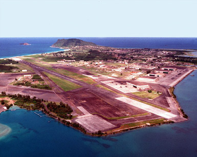
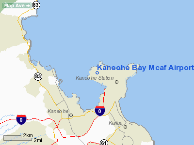
Marine Corps Air Station Kaneohe Bay or MCAS Kaneohe Bay (ICAO: PHNG, FAA LID: NGF) is a United States Marine Corps airfield located within the Marine Corps Base Hawaii complex, formerly known as Marine Corps Air Facility Kaneohe Bay. It is located two miles (3 km) northeast of the central business district of Kaneohe, in Honolulu County, Hawaii, United States. The airfield has one runway (4/22) with a 7,771 x 200 ft (2,369 x 61 m) asphalt surface. Resident units
HistoryThe United States Army acquired 322 acres (1.30 km) of the peninsula when President Woodrow Wilson signed executive order 2900 establishing the Kuwaaohe Military Reservation. Little is known about the operations of the fort, however, at the end of World War I, the military property was leased for ranching. In 1939, Kuwaaohe was reactivated, subjected to many name changes to include Camp Ulupaâu, and eventually named Fort Hase. Prior to and during World War II, Fort Hase grew from a humble beginning as a defense battalion to a major unit of the Windward Costal Artillery Command. Navy planners began to eye the peninsula in 1939 as the home of a strategic seaplane base. They liked the isolated location, the flat plains for an airfield and the probability of flights into prevailing trade winds. In 1939, the Navy acquired 464 acres (1.88 km) of the peninsula for use of the PBY Catalina Patrol seaplanes for long-range reconnaissance flights. One year later, the Navy owned all of the Mokapu Peninsula except for Fort Hase.
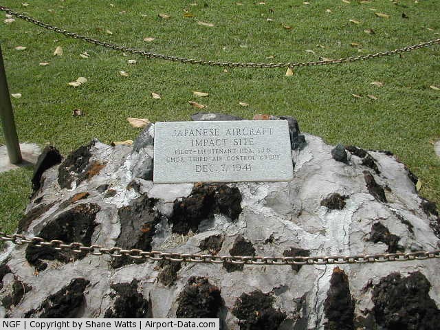
On December 7, 1941, the Imperial Japanese Navy attacked the air station minutes prior to the attack on Pearl Harbor. Of the 36 Catalinas stationed here, 27 were destroyed and six others were damaged, along with 18 sailors who perished in the attack. The first Japanese aircraft destroyed in action were shot down at Kaneohe, along with Aviation Ordnanceman Chief Petty Officer John William Finn becoming one of the first Medal of Honor recipients of World War II for valor on that day. During the war, the air station was a major training base in the Pacific Theater. The Fleet Gunnery School trained thousands of Navy gunners. There was a school for celestial navigation, sonar, aircraft recognition, and turret operations. Flight instructors also trained Navy and Marine Corps aviators in flight operations prior to being sent to a forward combat area. Following the war, Fort Hase had become a skeleton outpost and the air station consisted of limited air operations, a small security detachment, and a federal communications center. In 1949, the Navy decommissioned the air station. On January 15, 1952 the Marine Corps re-commissioned the idle airfield Marine Corps Air Station Kaneohe Bay, making it an ideal training site for a combined air/ground team. Station Operations and Headquarters Squadron supported flight operations until June 30, 1972, when Station Operations and Maintenance Squadron was commissioned in its place. SOMS served until it was disbanded on July 30, 1994. Marine Corps Air Facility Kaneohe Bay was formed on that date and continues today to serve the operational needs of the aviation community. Following the 1993 Base Realignment and Closure Committeeâs decision to close Naval Air Station Barbers Point, the base acquired 4 Navy P-3 Orion patrol squadrons and one SH-60 Seahawk Anti-Submarine squadron in 1999. Today there are almost 10,000 active duty Navy and Marine Corps personnel attached to the base. The installation was re-designated as an Air Station (vice an Air Facility) in May 2009. At the same time, the airfield was named for MajGen Marion Eugene Carl, and the Corps announced that new squadrons would be stationed there. The above content comes from Wikipedia and is published under free licenses – click here to read more.
Runway InformationRunway 04/22
Radio Navigation Aids
Remarks
Kaneohe Bay Mcaf Airport Address: Honolulu County, HI Tel: Images
and information placed above are from We thank them for the data!
We don't guarantee the information is fresh and accurate. The data may
be wrong or outdated.
|
||||||||||||||||||||||||||||||||||||||||||||||||||||||||||||||||||||||||||||||||||||||||||||||||||||||||||||||||||||||||||||||||||||||||||||||||||||||||||||||||||||||||||||||||||||||||||||||||||||||||||||||||||||||||||||||||||||||||||||||||||||||||||||||||||||||||||||||||||||||||||||

 |
|
Copyright 2004-2026 © by Airports-Worldwide.com, Vyshenskoho st. 36, Lviv 79010, Ukraine Legal Disclaimer |