|
|
| Kalaupapa Airport |
 |
| IATA: LUP â ICAO: PHLU â FAA LID: LUP |
| Summary |
| Airport type |
Public |
| Operator |
Hawaii Department of Transportation |
| Serves |
Kalaupapa, Hawaii |
| Elevation AMSL |
24 ft / 7 m |
| Coordinates |
21°12â²40â³N 156°58â²25â³W / 21.21111°N 156.97361°W / 21.21111; -156.97361 |
| Website |
hawaii.gov/lup |
| Runways |
| Direction |
Length |
Surface |
| ft |
m |
| 5/23 |
2,700 |
823 |
Asphalt |
| Statistics (2008) |
| Aircraft operations |
2,465 |
| Source: Federal Aviation Administration |
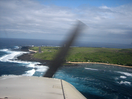
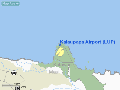
Kalaupapa Airport (IATA: LUP, ICAO: PHLU, FAA LID: LUP) is a regional airport of the State of Hawai'i, located on the northern peninsula of the island of Moloka'i, two nautical miles (3.7 km) north of Kalaupapa Settlement. Most flights to Kalaupapa originate from commuter airports on the other Hawaiian islands by unscheduled air taxis and general aviation. It is also used as a cargo facility carrying goods for Moloka'i distribution via Honolulu International Airport.
The only scheduled commercial airline is Pacific Wings, with service formerly subsidized by the Essential Air Service program. On April 1, 2007, Pacific Wings began providing subsidy-free service. Facilities and aircraft
Kalaupapa Airport covers an area of 55 acres (22 ha) at an elevation of 24 feet (7 m) above mean sea level. It has one runway designated 5/23 with an asphalt surface measuring 2,700 by 75 feet (823 x 23 m). Facilities include a small passenger terminal and airport support areas. The airport does not have a control tower. To comply with the wishes of the community and to minimize disturbance to the surrounding national park, no significant improvements are planned.
For the 12-month period ending December 31, 2008, the airport had 2,465 aircraft operations, an average of 205 per month: 68% air taxi, 16% general aviation, and 16% military.
Airlines and destinations
| Airlines |
Destinations |
| Pacific Wings |
Honolulu |
Authority
Kalaupapa Airport is part of a centralized state structure governing all of the airports and seaports of Hawai'i. The official authority of Kalaupapa Airport is the Governor of Hawai'i. He or she appoints the Director of the Hawai'i State Department of Transportation who has jurisdiction over the Hawai'i Airports Administrator.
The Hawai'i Airports Administrator oversees six governing bodies: Airports Operations Office, Airports Planning Office, Engineering Branch, Information Technology Office, Staff Services Office, Visitor Information Program Office. Collectively, the six bodies have authority over the four airport districts in Hawai'i: Hawai'i District, Kaua'i District, Mau'i District and the principal O'ahu District. Kalaupapa Airport is a subordinate of the Mau'i District officials.
The above content comes from Wikipedia and is published under free licenses – click here to read more.
Location
& QuickFacts
|
FAA
Information Effective: |
2007-07-05 |
|
Airport
Identifier: |
LUP |
|
Airport
Status: |
Operational |
|
Longitude/Latitude: |
156-58-24.9500W/21-12-39.7450N
-156.973597/21.211040 (Estimated) |
|
Elevation: |
24 ft / 7.32 m (Surveyed) |
|
Land: |
55 acres |
|
From
nearest city: |
2 nautical miles N of Kalaupapa, HI |
|
Location: |
Kalawao County, HI |
|
Magnetic Variation: |
11E (1985) |
Owner
& Manager
|
Ownership: |
Publicly
owned |
|
Owner: |
Hawaii State Airports Division |
|
Address: |
400 Rodgers Blvd Suite 700
Honolulu, HI 96819 |
|
Phone
number: |
808-838-8701 |
|
Manager: |
James Davis
ARPT OPNS/MAINT/ MAN/ADM/-MR. CARL BRITO PHONE MOLOKAI 567-6140. |
|
Address: |
Kahului Airport
Kahului, HI 96732 |
|
Phone number: |
808-872-3830 |
Airport
Operations and Facilities
|
Airport
Use: |
Open
to public |
|
Wind
indicator: |
Yes |
|
Segmented Circle: |
Yes |
|
Control
Tower: |
No |
|
Lighting
Schedule: |
RDO-CTL
ARPT BCN OTS INDEFLY. |
|
Beacon
Color: |
Clear-Green (lighted land airport) |
|
Landing
fee charge: |
No |
|
Sectional chart: |
Hawaiian Islands |
|
Region: |
AWP - Western-Pacific |
|
Traffic
Pattern Alt: |
776 ft |
|
Boundary
ARTCC: |
ZHN - Honolulu Control Facility |
|
Tie-in
FSS: |
HNL - Honolulu |
|
FSS
on Airport: |
No |
|
FSS
Phone: |
808-836-8049 |
|
FSS
Toll Free: |
1-800-WX-BRIEF |
|
NOTAMs
Facility: |
MKK (NOTAM-d service avaliable) |
|
Certification type/date: |
III A S 06/20 |
|
Federal Agreements: |
N |
Airport
Communications
Airport
Services
|
Airframe
Repair: |
NONE |
|
Power
Plant Repair: |
NONE |
|
Bottled
Oxygen: |
NONE |
|
Bulk
Oxygen: |
NONE |
|
Runway Information
Runway 05/23
|
Dimension: |
2700
x 75 ft / 823.0 x 22.9 m |
|
Surface: |
ASPH, Good Condition |
|
Weight
Limit: |
Single wheel: 17000 lbs. |
|
Edge
Lights: |
Medium |
|
|
Runway 05 |
Runway 23 |
|
Longitude: |
156-58-37.4780W |
156-58-12.4210W |
|
Latitude: |
21-12-33.3430N |
21-12-46.1450N |
|
Elevation: |
24.00 ft |
23.00 ft |
|
Alignment: |
61 |
127 |
|
Traffic
Pattern: |
Left |
Right |
|
Markings: |
Basic, Fair Condition |
Basic, Fair Condition |
|
Crossing
Height: |
25.00 ft |
0.00 ft |
|
VASI: |
2-light PAPI on left side
RY 05 PAPI OTS INDEFLY. |
|
|
Visual
Glide Angle: |
2.75° |
0.00° |
|
Runway
End Identifier: |
No |
No |
|
Centerline
Lights: |
No |
No |
|
Touchdown
Lights: |
No |
No |
|
Radio Navigation
Aids
|
ID |
Type |
Name |
Ch |
Freq |
Var |
Dist |
|
LLD |
NDB |
Lanai |
|
353.00 |
11E |
26.4 nm |
|
VYI |
NDB |
Valley Island |
|
327.00 |
11E |
35.8 nm |
|
NGF |
TACAN |
Kaneohe Bay |
093X |
|
11E |
46.5 nm |
|
MKK |
VORTAC |
Molokai |
108X |
116.10 |
11E |
11.7 nm |
|
LNY |
VORTAC |
Lanai |
124X |
117.70 |
11E |
26.8 nm |
|
OGG |
VORTAC |
Maui |
098X |
115.10 |
11E |
36.0 nm |
|
CKH |
VORTAC |
Koko Head |
086X |
113.90 |
11E |
41.0 nm |
Remarks
- SEE
AREA NOTICES - TRAFFIC ADVISORIES AT NON-TOWER ARPTS.
- 24
HRS PPR FOR CLASS A AND B EXPLOSIVES AND 4 HRS PPR FOR OTHER HAZARDOUS
MATERIAL IN/OUT OF ARPT CTC 808-567-6140/6008.
- PPR
FM ST DEPT OF HEALTH COMMUNICABLE DISEASE DIV TO ENTER SETTLEMENT AREA
PHONE HONOLULU 808-586-4580.
- DEER
& WILD ANIMALS ON & INVOF ARPT AT NIGHT.
- DEEP
RUTS ALONG NORTHEAST RY SHOULDER CAUSED BY WILD BOARS.
- OCT-MAY
LARGE WAVES IMPACTING SHORELINE RESULTING IN SALT WATER SPRAYS 40 FT
HIGH.
Operational
Statistics
Time Period: 2006-01-01 - 2006-12-31
|
Aircraft
Operations: |
48/Week |
|
Commerical: |
59.2% |
|
Air
Taxi: |
8.4% |
|
General
Aviation Itinerant: |
16.2% |
|
Military: |
16.2% |
Kalaupapa Airport
Address:
Kalawao County, HI
Tel:
808-838-8701,
808-872-3830
Images
and information placed above are from
http://www.airport-data.com/airport/LUP/
We
thank them for the data!
| General
Info |
| Country |
United
States |
| State |
HAWAII
|
| FAA ID |
LUP |
| Latitude |
21-12-39.745N
|
| Longitude |
156-58-24.950W
|
| Elevation |
24 feet
|
| Near City |
KALAUPAPA
|
We don't guarantee the information is fresh and accurate. The data may
be wrong or outdated.
For more up-to-date information please refer to other sources.
|
|