 |
|
Kalaeloa (John Rodgers Field) Airport |
Kalaeloa Airport
John Rodgers Field |
 |
| IATA: none â ICAO: PHJR â FAA LID: JRF |
| Summary |
| Airport type |
Public |
| Operator |
Hawaii Department of Transportation |
| Location |
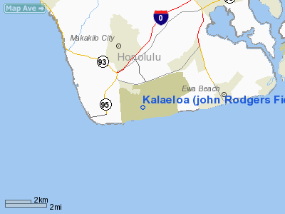
Kapolei, Hawaii |
| Elevation AMSL |
30 ft / 9 m |
| Coordinates |
21°18â²26â³N 158°04â²13â³W / 21.30722°N 158.07028°W / 21.30722; -158.07028 (Kalaeloa Airport)Coordinates: 21°18â²26â³N 158°04â²13â³W / 21.30722°N 158.07028°W / 21.30722; -158.07028 (Kalaeloa Airport) |
| Website |
hawaii.gov/jrf |
| Runways |
| Direction |
Length |
Surface |
| ft |
m |
| 4L/22R |
4,500 |
1,372 |
Asphalt |
| 4R/22L |
8,000 |
2,438 |
Asphalt |
| 11/29 |
6,000 |
1,829 |
Asphalt |
| Statistics (ending 31 December 2008) |
| Operations |
139,710 |
| Based aircraft |
22 |
| Source: Federal Aviation Administration |
Aerial view of NAS Barbers Point in 1976. Kalaeloa Airport (ICAO: PHJR, FAA LID: JRF), also called John Rodgers Field (the original name of Honolulu International Airport) and formerly Naval Air Station Barbers Point, is a joint civil-military regional airport of the State of Hawaiʻi established on July 1, 1999 to replace the Ford Island NALF facilities which closed on June 30 of the same year. Located on the site of the developing unincorporated town of Kalaeloa and nestled between the Honolulu communities of ʻEwa Beach, Kapolei and Campbell Industrial Park in West Oʻahu, most flights to Kalaeloa Airport originate from commuter airports on the other Hawaiian islands. Kalaeloa Airport is primarily a commuter facility used by unscheduled air taxis, general aviation and transient and locally-based military aircraft. Authority
Kalaeloa Airport is part of a centralized state structure governing all of the airports and seaports of Hawaiʻi. The official authority of Kalaeloa Airport is the Governor of Hawaiʻi. He or she appoints the Director of the Hawaiʻi State Department of Transportation who has jurisdiction over the Hawaiʻi Airports Administrator.
The Hawaiʻi Airports Administrator oversees six governing bodies: Airports Operations Office, Airports Planning Office, Engineering Branch, Information Technology Office, Staff Services Office, Visitor Information Program Office. Collectively, the six bodies have authority over the four airport districts in Hawaiʻi: Hawaiʻi District, Kauaʻi District, Maui District and the principal Oʻahu District. Kalaeloa Airport is a subordinate of the Oʻahu District officials.
NAS Barbers Point was closed by Base Realignment and Closure (BRAC) action in the 1990s, with the Navy aircraft, primarily P-3C Orion maritime patrol aircraft assigned to squadrons of Patrol Wing Two, relocating to Kaneohe Marine Corps Air Station, now Marine Corps Base Hawaii, on the other side of the island. However, Coast Guard Air Station Barbers Point, with its complement of HH-65 Dolphin helicopters and HC-130H Hercules aircraft, remained after the Navy's departure. Coast Guard Air Station Barbers Point is the only Coast Guard Air Station within the 14th United States Coast Guard District.
The above content comes from Wikipedia and is published under free licenses – click here to read more.
Location
& QuickFacts
|
FAA
Information Effective: |
2007-07-05 |
|
Airport
Identifier: |
JRF |
|
Airport
Status: |
Operational |
|
Longitude/Latitude: |
158-04-13.0860W/21-18-26.4740N
-158.070302/21.307354 (Estimated) |
|
Elevation: |
30 ft / 9.14 m (Estimated) |
|
Land: |
752 acres |
|
From
nearest city: |
2 nautical miles S of Kapolei, HI |
|
Location: |
Honolulu County, HI |
|
Magnetic Variation: |
11E (1985) |
Owner
& Manager
|
Ownership: |
Publicly
owned |
|
Owner: |
Hawaii State Airports Division |
|
Address: |
400 Rodgers Blvd, Suite 700
Honolulu, HI 96819-1880 |
|
Phone
number: |
808-838-8600 |
|
Manager: |
Ben Schlapak
ASSISTANT AIRPORT SUPERINTENDENT IV ROBERT RAMOS PHONE (808)
682-6422 |
|
Address: |
300 Rodgers Blvd #12
Honolulu, HI 96819-1897 |
|
Phone number: |
808-836-6533 |
Airport
Operations and Facilities
|
Airport
Use: |
Open
to public |
|
Wind
indicator: |
Yes |
|
Segmented Circle: |
No |
|
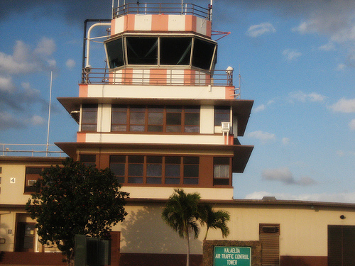
Control
Tower: |
Yes |
|
Lighting
Schedule: |
DUSK-DAWN
WHEN ATCT CLSD ACTVT HIRL RY 04R/22L, MIRL RY 04L/22R AND
MIRL RY 11/29, MALSF RY 04R AND TWY LIGHTS - CTAF. PAPI
RYS 04R AND 22L, RYS 04L AND 22R, RYS 11 AND 29 OPER CONT. |
|
Beacon
Color: |
Clear-Green (lighted land airport) |
|
Sectional chart: |
Hawaiian Islands |
|
Region: |
AWP - Western-Pacific |
|
Boundary
ARTCC: |
ZHN - Honolulu Control Facility |
|
Tie-in
FSS: |
HNL - Honolulu |
|
FSS
Phone: |
808-836-8049 |
|
FSS
Toll Free: |
1-800-WX-BRIEF |
|
NOTAMs
Facility: |
PHJR (NOTAM-d service avaliable) |
|
Federal Agreements: |
N |
Airport Communications
Airport
Services
|
Fuel
available: |
100LL
100LL - CALL (808) 923-6928 |
|
Bottled
Oxygen: |
NONE |
|
Bulk
Oxygen: |
NONE |
|
Runway Information
Runway 04L/22R
|
Dimension: |
4500
x 200 ft / 1371.6 x 61.0 m |
|
Surface: |
ASPH, Good Condition |
|
Edge
Lights: |
Medium |
|
|
Runway 04L |
Runway 22R |
|
Longitude: |
158-04-19.4200W |
158-03-40.4500W |
|
Latitude: |
21-18-24.6100N |
21-18-50.2100N |
|
Elevation: |
21.00 ft |
29.00 ft |
|
Alignment: |
55 |
127 |
|
Traffic
Pattern: |
Left |
Left |
|
Markings: |
Basic, Good Condition |
Basic, Good Condition |
|
Arresting: |
E28B |
E28B |
|
Crossing
Height: |
30.00 ft |
30.00 ft |
|
VASI: |
2-light PAPI on left side |
2-light PAPI on left side |
|
Visual
Glide Angle: |
3.00° |
3.00° |
|
Runway 04R/22L
|
Dimension: |
8000
x 200 ft / 2438.4 x 61.0 m |
|
Surface: |
ASPH, Good Condition |
|
Edge
Lights: |
High |
|
|
Runway 04R |
Runway 22L |
|
Longitude: |
158-04-45.9400W |
158-03-36.6600W |
|
Latitude: |
21-17-59.6300N |
21-18-45.1400N |
|
Elevation: |
11.00 ft |
27.00 ft |
|
Alignment: |
55 |
127 |
|
Traffic
Pattern: |
Left |
Left |
|
Markings: |
Precision instrument, Fair Condition |
Basic, Fair Condition |
|
Crossing
Height: |
30.00 ft |
30.00 ft |
|
VASI: |
4-light PAPI on left side |
4-light PAPI on left side |
|
Visual
Glide Angle: |
3.00° |
3.00° |
|
Approach
lights: |
MALSF |
|
|
Runway 11/29
|
Dimension: |
6000
x 200 ft / 1828.8 x 61.0 m |
|
Surface: |
ASPH, Good Condition |
|
Weight
Limit: |
Single wheel: 74000 lbs.
Dual wheel: 167000 lbs.
Dual tandem wheel: 327000 lbs.
Dual dual tandem wheel: 800000 lbs.
GROSS WT (IN THSDS) SINGLE-TANDEM: 189. |
|
Edge
Lights: |
Medium |
|
|
Runway 11 |
Runway 29 |
|
Longitude: |
158-04-53.3400W |
158-03-57.3200W |
|
Latitude: |
21-18-37.6900N |
21-18-09.7600N |
|
Elevation: |
30.00 ft |
10.00 ft |
|
Alignment: |
118 |
127 |
|
Traffic
Pattern: |
Right |
Left |
|
Markings: |
Basic, Good Condition |
Basic, Good Condition |
|
Crossing
Height: |
30.00 ft |
30.00 ft |
|
VASI: |
4-light PAPI on left side |
4-light PAPI on left side |
|
Visual
Glide Angle: |
3.00° |
3.00° |
|
Radio Navigation
Aids
|
ID |
Type |
Name |
Ch |
Freq |
Var |
Dist |
|
HN |
NDB |
Ewabe |
|
242.00 |
11E |
1.6 nm |
|
HHI |
NDB |
Wheeler |
|
373.00 |
11E |
10.5 nm |
|
NGF |
TACAN |
Kaneohe Bay |
093X |
|
11E |
19.2 nm |
|
HNL |
VORTAC |
Honolulu |
095X |
114.80 |
11E |
7.8 nm |
|
CKH |
VORTAC |
Koko Head |
086X |
113.90 |
11E |
20.7 nm |
|
HNL |
VOT |
Honolulu |
|
111.00 |
|
8.0 nm |
Remarks
- POTENTIAL
HYDROPLANING ALL ACFT DUE STANDING WATER AT INTXN RY 04R AND RY 11.
- PPR
ALL AIRCRAFT 225,000 LBS GWT OR OVER, CTC HONOLULU INTL ARPT DUTY MGR
AT (808) 836-6515.
- OCNL
BIRD HAZ APCH END RY 04L AND RY 04R.
- MILITARY
HELICOPTER OPNS ON & INVOF ARPT DUE TO USCG MILITARY HELIPAD NEAR
RY 04R.
- NOISE
ABATEMENT PROCEDURE: RY 11 DEP ONLY, RY 29 ARR ONLY. AVOID OVERFLIGHT
RESIDENTIAL AREAS AND SCHOOLS NORTH AND EAST OF ARPT.
- AVOID
OVERFLIGHT REFINERIES WEST OF ARPT, GASEOUS EXHAUST PLUMES AND FLAMES
MAY RISE TO 267 FT AGL WITHOUT WARNING.
Based
Aircraft
|
Aircraft
based on field: |
28 |
|
Single
Engine Airplanes: |
8 |
|
Multi
Engine Airplanes: |
6 |
|
Jet
Engine Airplanes: |
2 |
|
Helicopters: |
4 |
|
Military: |
8 |
Operational Statistics
Time Period: 2004-01-02 - 2004-12-31
|
Aircraft
Operations: |
449/Day |
|
Air
Taxi: |
0.7% |
|
General
Aviation Local: |
75.7% |
|
General
Aviation Itinerant: |
9.8% |
|
Military: |
13.8% |
Kalaeloa (john Rodgers Field) Airport
Address:
Honolulu County, HI
Tel:
808-838-8600,
808-836-6533
Images
and information placed above are from
http://www.airport-data.com/airport/JRF/
We
thank them for the data!
| General
Info |
| Country |
United
States |
| State |
HAWAII
|
| FAA ID |
JRF |
| Latitude |
21-18-26.474N
|
| Longitude |
158-04-13.086W
|
| Elevation |
33 feet
|
| Near City |
KAPOLEI
|
We don't guarantee the information is fresh and accurate. The data may
be wrong or outdated.
For more up-to-date information please refer to other sources.
|
|


