|
|
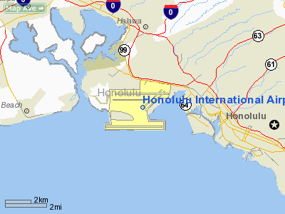
Honolulu International Airport |
- For the civil airport use of this facility, see Honolulu International Airport.
Hickam Air Force Base is a United States Air Force base located in the City and County of Honolulu on the island of Oʻahu, state of Hawaii. The base is named in honor of aviation pioneer Lt. Col. Horace Meek Hickam. Hickam AFB consists of 2,850 acres (12 km²) of land and facilities bordering Pearl Harbor, valued at more than $444 million. It is under the operational control of Pacific Air Forces (PACAF), which is headquartered on the base, and is also home to PACAF's 15th Airlift Wing (15 AW), the Hawaii Air National Guard's 154th Wing (154 WG), which is operationally gained by PACAF, and Air Mobility Command's 515th Air Mobility Operations Wing (515 AMOW). The 15 AW functions as the "host wing" for the base. The housing around the base is within the Hickam Housing CDP. Geography and Physical Layout
Hickam AFB was originally bounded on the north by Pearl Harbor Naval Shipyard, on the west by the Pearl Harbor entrance channel, on the south by Fort Kamehameha, and on the east by the airport complex.
Hickam AFB shares its runways with the adjacent Honolulu International Airport (IATA: HNL, ICAO: PHNL) under a shared-use agreement established a single airport complex.
The Hickam AFB main gate is reached via Nimitz Highway (Hawaii Route 92) from Honolulu, and it shares its western terminus with the Pearl Harbor Naval Shipyard's main gate. This part of Nimitz Highway can be reached from the expressway Interstate H-1 (Exit 15) southeast from Halawa or west from Honolulu (Exit 15B) and from Kamehameha Highway (State Hawaii Route 99), the eastern termination of which is at Nimitz Highway.
Joint Base Pearl Harbor-Hickam
On January 31, 2010, Hickam AFB and the Pearl Harbor Naval Base were formally combined into the Joint Base Pearl Harbor-Hickam.
An information center has been set up on the official website of Hickam Air Force Base.
BRAC 2005
Secretary of Defense's Recommendation: Realign Grand Forks Air Force Base, North Dakota. This would distribute the 319th Air Refueling Wing's KC-135R Stratotanker aircraft to the 154th Wing (ANG), Hickam AFB, Hawaii, (four aircraft) and to several other installations. The 154th Wing would also host an active duty associate unit with the 15th Air Wing for the C-17 Globemaster III.
Demographics
As of the 2000 United States Census, there were 5,471 people, 1,632 households, and 1,589 families residing at Hickam. The population density was 1,703.5/km² (4,419.0/mi²). There were 1,718 housing units at an average density of 534.9/km² (1,387.7/mi²). The racial makeup of the town was 66.20% White, 11.72% Black, 0.57% Native American, 8.21% Asian, 0.97% Pacific Islander, 4.08% from other races, and 8.26% from two or more races. 8.37% of the population were Hispanic or Latino of any race.
In 2000, there were 1,632 households out of which 73.3% had children under the age of 18 living with them, 90.9% were married couples living together, 3.8% had a female householder with no husband present, and 2.6% were non-families. 2.5% of all households were made up of individuals and 0.0% had someone living alone who was 65 years of age or older. The average household size was 3.35 and the average family size was 3.40.
On the base, the population was spread out with 40.4% under the age of 18, 7.9% from 18 to 24, 45.5% from 25 to 44, 5.9% from 45 to 64, and 0.3% who were 65 years of age or older. The median age was 26 years. For every 100 females there were 102.3 males. For every 100 females age 18 and over, there were 100.2 males.
The median income for a household at Hickam was $42,298, and the median income for a family was $41,989. Males had a median income of $30,588 versus $23,548 for females. The per capita income for the CDP was $15,039; 2.2% of the population and 2.1% of families were below the poverty line. Out of the total population, 2.6% of those under the age of 18 and 25.0% of those 65 and older were living below the poverty line.
UnitsHickam Air Force Base is home to the 15th Airlift Wing (15 AW) and 67 partner units including Headquarters, United States Pacific Air Forces (PACAF), Headquarters - Hawaii Air National Guard and the 154th Wing (154 WG) of the Hawaii Air National Guard. In all, Hickam supports 140 tenant and associate units.
The 15th Airlift Wing is composed of four groups each with specific functions. The 15th Operations Group (15 OG) controls all flying and airfield operations. The 15th Maintenance Group (15 MXG) performs aircraft and aircraft ground equipment maintenance. The 15th Mission Support Group (15 MSG) has a wide range of responsibilities but a few of its functions are Security, Civil Engineering, Communications, Personnel Management, Logistics, Services and Contracting support. The 15th Medical Group (15 MG) provides medical and dental care. History
Major CommandsBase operating unitsMajor USAAF/USAF units assigned
Flying:
- 5th Bombardment Group (B-17, B-18) (January 1939 - November 1942)
- 11th Bombardment Group (B-17) (February 1940 - July 1942, April - November 1943)
- 19th Troop Carrier Group (C-47) (January 1941 - August 1948)
- 90th Bombardment Group (B-24) (September - November 1942)
- 318th Fighter Group (P-39, P-40, P-47) (October 1942 - June 1944)
- 307th Bombardment Group (B-24) (November 1942 - February 1943)
- 38th Bombardment Group (B-24) (October - November 1943)
- 41st Bombardment Group (B-25) (October - December 1943)
- 1500th Air Transport Group (C-47, C-54) (June 1948 - May 1958)
- 50th Military Airlift Squadron (July 1952 - December 1969)
- 1502d Air Transport Wing (July 1955 - January 1966)
- 61st Military Airlift Wing (September 1966 - 1992)
- 15th Airlift Wing (November 1971âpresent)
- 154th Wing (19?? - Present)
Non-flying:
- Hawaiian Air Depot (April 1943 - May 1948)
Operational history
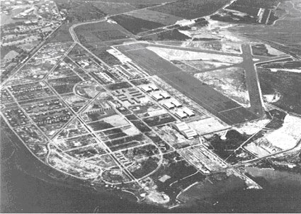 | |
Hickam Field, 1940. Pearl Harbor Navy Yard is in the upper left corner |
History shows Hickam played a pivotal role in past Pacific operations - bullet-scarred walls are still visible from the December 7th, 1941 attack that pushed the U.S. into World War II.
Origins
In 1934, the Army Air Corps saw the need for another airfield in Hawaii and assigned the Quartermaster Corps the job of constructing a modern airdrome from tangled brush and sugar cane fields adjacent to Pearl Harbor. The site consisted of 2,200 acres (9 km²) of ancient, emerged coral reef covered by a thin layer of soil, with the Pearl Harbor entrance channel and naval reservation marking its western and northern boundaries, John Rodgers Airport (HIA today) to the east, and Fort Kamehameha on the south. The new airfield was dedicated on 31 May 1935 and named in honor of Lt Col Horace Meek Hickam, a distinguished aviation pioneer who was killed in an aircraft accident the previous November 5 when his Curtiss A-12 Shrike, 33-250, hit an obstruction during night landing practice on the unlighted field at Fort Crockett in Galveston, Texas and overturned.
Construction was still in progress when the first contingent of 12 men and four aircraft under the command of 1st Lt Robert Warren arrived from Luke Field on Ford Island on September 1, 1937. Hickam Field, as it was then known, was completed and officially activated on September 15, 1938. It was the principal army airfield in Hawaiâi and the only one large enough to accommodate the B-17 Flying Fortress bomber. In connection with defense plans for the Pacific, aircraft were brought to Hawaiâi throughout 1941 to prepare for potential hostilities.
The first mass flight of bombers (21 B-17Ds) from Hamilton Field, California arrived at Hickam on 14 May 1941. By December, the "Hawaiian Air Force" had been an integrated command for slightly more than one year and consisted of 754 officers and 6,706 enlisted men, with 233 aircraft assigned at its three primary bases: Hickam, Wheeler Field (now Wheeler Army Airfield), and Bellows Field (now Bellows Air Force Station).
World War II
When the Imperial Japanese Navy attacked Oâahu's military installations on 7 December 1941, their planes bombed and strafed Hickam to eliminate air opposition and prevent U.S. planes from following them back to their aircraft carriers. Hickam suffered extensive damage and aircraft losses, with 189 people killed and 303 wounded.
During World War II, the base became a major center for training pilots and assembling aircraft. It also served as the hub of the Pacific aerial network, supporting transient aircraft ferrying troops and supplies toâand evacuating wounded fromâthe forward areasâa role it would reprise during the Korean and Vietnam wars and earning it the official nickname "America's Bridge Across the Pacific".
Cold War
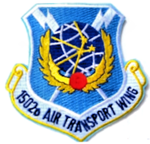 | |
Emblem of the MATS 1502d Air Transport Wing (1955-1966) |
After World War II, the Air Force in Hawaiâi consisted primarily of the Air Transport Command and its successor, the Military Air Transport Service (MATS), until 1 July 1957 when Headquarters Far East Air Forces completed its move from Japan to Hawaiâi and was redesignated the Pacific Air Forces (PACAF). The 15th Air Base Wing, host unit at Hickam AFB, supported the Apollo astronauts in the 1960s and 1970s; Operation Homecoming (return of prisoners of war from Vietnam) in 1973; Operation Babylift / New Life (movement of nearly 94,000 orphans, refugees, and evacuees from Southeast Asia) in 1975; and NASA's space shuttle flights in the 1980s and 1990s. Hickam is home to the 65th Airlift Squadron which transports theater senior military leaders throughout the world in the C-37 and C-40 aircraft. In mid-2003, the 15th Air Base Wing (15 ABW) was converted to the 15th Airlift Wing (15 AW)as it prepared to beddown and fly the Air Force's newest transport aircraft, the C-17 Globemaster III. The first Hickam-based C-17 arrived in February 2006, with seven more to follow during the year. The C-17s will be flown by the 535th Airlift Squadron.
On September 16, 1985, the Secretary of the Interior designated Hickam AFB a National Historic Landmark, recognizing its key role in the World War II Pacific campaign. A bronze plaque reflecting Hickam's "national significance in commemorating the history of the United States of America" took its place among other memorials surrounding the base flagpole. Dominating the area is a large bronze tablet engraved with the names of those who died as a result of the 1941 attack. Other reminders of the attack can still be seen. Bullet holes mark many buildings in use, including WWII era hangers and the base hospital., including the tattered American flag that flew over the base that morning. It is on display in the lobby of the Pacific Air Forces Headquarters building, whose bullet-scarred walls (the structure was a barracks and mess hall known as "the Big Barracks" in 1941) have been carefully preserved as a reminder to never again be caught unprepared.
Current use
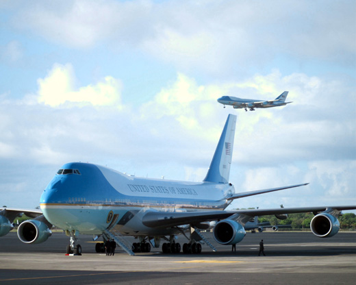 | |
Air Force One (in air) and its backup on the ground during a 2003 visit by George W. Bush |
Today, the 15 AW remains the launch point of strategic air mobility and operational missions in support of the Global War on Terrorism as well as special air missions in support of the Commander, U.S. Pacific Command (USPACOM) and Commander, Pacific Air Forces (PACAF).
In 2009 the base was used as headquarters for Air Force One during Barack Obama's Christmas vacation at Kailua, Hawaii.
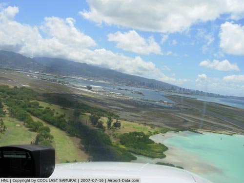
Hickam Photo Gallery
The above content comes from Wikipedia and is published under free licenses – click here to read more.
|
 |
(Click on the photo to enlarge) |
|
 |
(Click on the photo to enlarge) |
Location
& QuickFacts
|
FAA
Information Effective: |
2007-07-05 |
|
Airport
Identifier: |
HNL |
|
Airport
Status: |
Operational |
|
Longitude/Latitude: |
157-55-20.7432W/21-19-07.2526N
-157.922429/21.318681 (Estimated) |
|
Elevation: |
13 ft / 3.96 m (Surveyed) |
|
Land: |
4220 acres |
|
From
nearest city: |
3 nautical miles NW of Honolulu, HI |
|
Location: |
Honolulu County, HI |
|
Magnetic Variation: |
11E (1990) |
Owner
& Manager
|
Ownership: |
Publicly
owned |
|
Owner: |
State Of Hawaii |
|
Address: |
Honolulu Intl Airport
Honolulu, HI 96819 |
|
Phone
number: |
808-838-8600 |
|
Manager: |
Ben Schlapak
AIRSIDE MGR JIM PRATT - (808) 836-6428. |
|
Address: |
300 Rodgers Blvd. #12
Honolulu, HI 96819-1897 |
|
Phone number: |
808-836-6533 |
Airport
Operations and Facilities
|
Airport
Use: |
Open
to public |
|
Wind
indicator: |
Yes |
|
Segmented Circle: |
No |
|
Control
Tower: |
Yes |
|
Lighting
Schedule: |
DUSK-DAWN |
|
Beacon
Color: |
Clear-Green (lighted land airport) |
|
Landing
fee charge: |
No
LNDG FEE AND STORAGE CHARGES COLLBL ON ARR. |
|
Sectional chart: |
Hawaiian Islands |
|
Region: |
AWP - Western-Pacific |
|
Boundary
ARTCC: |
ZHN - Honolulu Control Facility |
|
Tie-in
FSS: |
HNL - Honolulu |
|
FSS
on Airport: |
No |
|
FSS
Phone: |
808-836-8049 |
|
FSS
Toll Free: |
1-800-WX-BRIEF |
|
NOTAMs
Facility: |
HNL (NOTAM-d service avaliable) |
|
Certification type/date: |
I E S 05/1973 |
|
Federal Agreements: |
NGPSY3 |
Airport Services
|
Fuel
available: |
100 80 A A1+ B
80/100 OCTANE FUEL AVBL THRU FBO. |
|
Airframe
Repair: |
MAJOR |
|
Power
Plant Repair: |
MAJOR |
|
Bottled
Oxygen: |
HIGH/LOW |
|
Bulk
Oxygen: |
HIGH/LOW |
|
Runway Information
Runway 04L/22R
|
Dimension: |
6952 x 150 ft / 2119.0 x 45.7 m
200' WIDE WITH LGTS OUTSIDE, PVMT STRIPED 150' WIDE. |
|
Surface: |
ASPH, Good Condition |
|
Weight
Limit: |
Single wheel: 100000 lbs.
Dual wheel: 200000 lbs.
Dual tandem wheel: 400000 lbs.
Dual dual tandem wheel: 850000 lbs.
WIDE BODY 4-ENG-TBJTS LNDG RWY 04R ROLL TO END RWY; NO L TURN AT
TWY K WO ATCT APVL.
TWY K NOT HIGH SPEED EXIT TWY. |
|
Edge
Lights: |
Medium |
|
|
Runway 04L |
Runway 22R |
|
Longitude: |
157-55-23.9494W |
157-54-25.2246W |
|
Latitude: |
21-19-05.9941N |
21-19-47.4536N |
|
Elevation: |
10.00 ft |
8.00 ft |
|
Alignment: |
53 |
127 |
|
Traffic
Pattern: |
Left |
Left |
|
Markings: |
Non-precision instrument, Good Condition |
Non-precision instrument, Good Condition |
|
Crossing
Height: |
50.00 ft |
0.00 ft |
|
Displaced
threshold: |
0.00 ft |
150.00 ft |
|
VASI: |
4-light PAPI on left side |
|
|
Visual
Glide Angle: |
3.00° |
0.00° |
|
Runway
End Identifier: |
Yes |
Yes |
|
Centerline
Lights: |
No |
No |
|
Touchdown
Lights: |
No |
No |
|
Obstruction: |
, 50:1 slope to clear |
50 ft ant, 1500.0 ft from runway, 20 ft left
of centerline, 26:1 slope to clear |
|
Decleard
distances: |
Take off run available 6948.00 ft
Take off distance available 6948.00 ft
Actual stop distance available 6398.00 ft
Landing distance available 6398.00 ft |
Take off run available 6948.00 ft
Take off distance available 6948.00 ft
Actual stop distance available 6948.00 ft
Landing distance available 6798.00 ft |
|
Runway 04R/22L
|
Dimension: |
9000 x 150 ft / 2743.2 x 45.7 m
200' WIDE WITH LGTS OUTSIDE, PVMT STRIPED 150' WIDE. |
|
Surface: |
ASPH, Good Condition |
|
Surface
Treatment: |
Saw-cut or plastic Grooved |
|
Weight
Limit: |
Single wheel: 100000 lbs.
Dual wheel: 200000 lbs.
Dual tandem wheel: 400000 lbs.
Dual dual tandem wheel: 850000 lbs.
WIDE BODY 4-ENG-TBJTS LNDG RWY 04R ROLL TO END RWY; NO L TURN AT
TWY K WO ATCT APVL.
TWY K NOT HIGH SPEED EXIT TWY. |
|
Edge
Lights: |
High |
|
|
Runway 04R |
Runway 22L |
|
Longitude: |
157-55-37.6856W |
157-54-21.6469W |
|
Latitude: |
21-18-50.1049N |
21-19-43.7625N |
|
Elevation: |
8.00 ft |
9.00 ft |
|
Alignment: |
53 |
127 |
|
ILS
Type: |
ILS/DME |
|
|
Traffic
Pattern: |
Left |
Left |
|
Markings: |
Precision instrument, Fair Condition |
Precision instrument, Good Condition |
|
Arresting: |
BAK12 |
BAK14 |
|
Crossing
Height: |
71.00 ft |
52.00 ft |
|
VASI: |
4-light PAPI on right side |
4-box on left side
VASI UNUSBL BYD 2 NM FROM THR. RY 22L VASI GA 3.0DEG TCH 52
FT. |
|
Visual
Glide Angle: |
3.00° |
3.00° |
|
Approach
lights: |
MALSR |
|
|
Runway
End Identifier: |
Yes |
|
|
Centerline
Lights: |
|
No |
|
Touchdown
Lights: |
|
No |
|
Obstruction: |
20 ft tree, 1100.0 ft from runway, 200 ft right
of centerline, 46:1 slope to clear |
74 ft stack, 2000.0 ft from runway, 475 ft
right of centerline, 27:1 slope to clear |
|
Runway 04W/22W
|
Dimension: |
3000 x 150 ft / 914.4 x 45.7 m
200' WIDE WITH LGTS OUTSIDE, PVMT STRIPED 150' WIDE. |
|
Surface: |
WATER, |
|
|
Runway 04W |
Runway 22W |
|
Longitude: |
157-54-46.4400W |
157-54-21.7800W |
|
Latitude: |
21-18-53.0900N |
21-19-11.8000N |
|
Alignment: |
51 |
127 |
|
Traffic
Pattern: |
Left |
Left |
|
Runway 08L/26R
|
Dimension: |
12300 x 150 ft / 3749.0 x 45.7 m
200' WIDE WITH LGTS OUTSIDE, PVMT STRIPED 150' WIDE. |
|
Surface: |
ASPH, Good Condition |
|
Surface
Treatment: |
Saw-cut or plastic Grooved |
|
Weight
Limit: |
Single wheel: 100000 lbs.
Dual wheel: 200000 lbs.
Dual tandem wheel: 400000 lbs.
Dual dual tandem wheel: 780000 lbs.
WIDE BODY 4-ENG-TBJTS LNDG RWY 04R ROLL TO END RWY; NO L TURN AT
TWY K WO ATCT APVL.
TWY K NOT HIGH SPEED EXIT TWY. |
|
Edge
Lights: |
High |
|
|
Runway 08L |
Runway 26R |
|
Longitude: |
157-56-35.6392W |
157-54-25.5430W |
|
Latitude: |
21-19-30.8855N |
21-19-30.8830N |
|
Elevation: |
12.00 ft |
9.00 ft |
|
Alignment: |
90 |
127 |
|
ILS
Type: |
ILS |
|
|
Traffic
Pattern: |
Left |
Left |
|
Markings: |
Precision instrument, Fair Condition |
Precision instrument, Fair Condition |
|
Crossing
Height: |
80.00 ft |
0.00 ft |
|
VASI: |
4-light PAPI on left side |
6-box on left side
VASI UPPER GA 3.25 DEG TCH 96 FT ; LOWER GA 3.00 DEG TCH 52
FT . |
|
Visual
Glide Angle: |
3.00° |
0.00° |
|
Approach
lights: |
MALSR |
|
|
Runway
End Identifier: |
No |
Yes |
|
Centerline
Lights: |
No |
No |
|
Touchdown
Lights: |
No |
No |
|
Obstruction: |
, 50:1 slope to clear |
15 ft road, 600.0 ft from runway, 500 ft left
of centerline, 26:1 slope to clear |
|
Runway 08R/26L
|
Dimension: |
12000 x 200 ft / 3657.6 x 61.0 m
200' WIDE WITH LGTS OUTSIDE, PVMT STRIPED 150' WIDE. |
|
Surface: |
ASPH, Good Condition |
|
Surface
Treatment: |
Saw-cut or plastic Grooved |
|
Weight
Limit: |
Single wheel: 80000 lbs.
Dual wheel: 170000 lbs.
Dual tandem wheel: 400000 lbs.
Dual dual tandem wheel: 780000 lbs.
WIDE BODY 4-ENG-TBJTS LNDG RWY 04R ROLL TO END RWY; NO L TURN AT
TWY K WO ATCT APVL.
TWY K NOT HIGH SPEED EXIT TWY. |
|
Edge
Lights: |
High |
|
|
Runway 08R |
Runway 26L |
|
Longitude: |
157-56-45.0654W |
157-54-38.1545W |
|
Latitude: |
21-18-24.4941N |
21-18-24.4838N |
|
Elevation: |
10.00 ft |
10.00 ft |
|
Alignment: |
90 |
127 |
|
ILS
Type: |
|
LDA/DME |
|
Traffic
Pattern: |
Left |
Left |
|
Markings: |
Precision instrument, Good Condition |
Precision instrument, Fair Condition |
|
Arresting: |
|
BAK12 |
|
Crossing
Height: |
0.00 ft |
75.00 ft |
|
VASI: |
6-box on left side
VASI RY 08R UPPER GA 3.25 DEG TCH 96 FT; LOWER GA 3.0 DEG
TCH 52 FT. |
4-light PAPI on left side |
|
Visual
Glide Angle: |
0.00° |
3.00° |
|
Approach
lights: |
|
MALSF |
|
Runway
End Identifier: |
Yes |
No |
|
Centerline
Lights: |
No |
No |
|
Touchdown
Lights: |
No |
No |
|
Obstruction: |
, 50:1 slope to clear |
219 ft , 9000.0 ft from runway, 300 ft right
of centerline, 40:1 slope to clear |
|
Runway 08W/26W
|
Dimension: |
5000 x 300 ft / 1524.0 x 91.4 m
200' WIDE WITH LGTS OUTSIDE, PVMT STRIPED 150' WIDE. |
|
Surface: |
WATER, |
|
|
Runway 08W |
Runway 26W |
|
Longitude: |
157-55-00.0000W |
157-54-07.1300W |
|
Latitude: |
21-18-40.8500N |
21-18-39.9800N |
|
Alignment: |
91 |
127 |
|
Traffic
Pattern: |
Left |
Left |
|
Radio Navigation
Aids
|
ID |
Type |
Name |
Ch |
Freq |
Var |
Dist |
|
HN |
NDB |
Ewabe |
|
242.00 |
11E |
7.1 nm |
|
HHI |
NDB |
Wheeler |
|
373.00 |
11E |
11.4 nm |
|
NGF |
TACAN |
Kaneohe Bay |
093X |
|
11E |
11.9 nm |
|
HNL |
VORTAC |
Honolulu |
095X |
114.80 |
11E |
0.8 nm |
|
CKH |
VORTAC |
Koko Head |
086X |
113.90 |
11E |
12.7 nm |
|
MKK |
VORTAC |
Molokai |
108X |
116.10 |
11E |
43.7 nm |
|
HNL |
VOT |
Honolulu |
|
111.00 |
|
0.9 nm |
Remarks
- HOLD
LINE IN EFFECT FOR TWY RA BTN PORTION OF TWY CROSSING APCH ZONE FOR
RY 04L & RY 04R.
- MILITARY
A-GEAR: BAK 12/14 ARRESTING GEAR LCTD 1500 FT FM THLD RY 26L.
- PRIOR
TO ENG START ALL ACFT PARKING ON RAMP INDLG HAZ CARGO PADS WILL CTC
GND CTL.
- TWY
P CLSD TO ACFT OVER 12,500 LBS GWT.
- PPR
FM AMGR FOR TRANSPORATION OF CLASS A OR B EXPLOS IN AND/OR OUT OF HNL.
- DUE
TO NON-VISIBILITY TWR UNABLE TO DETERMINE IF THE FLWG AREAS ARE CLEAR
OF OBSTRUCTIONS AND/OR TFC: PORTIONS OF TWY RB BTN TWY B & RY 08R;
PORTIONS OF INTER-ISLAND ACFT PARKING RAMP.
- MILITARY:
PPR ALL ACFT UNITS PLANNING TO STAGE OPNS FM HICKAM AFB MUST CTC 15
OSS/OSX DSN 315-449-3129 NLT 3 WEEKS PRIOR REGARDLESS.
- MILITARY:
*ALL ARR NON-AMC AIRCREW MUST RPT TO HICKAM BASE OPS (BLDG 2050) TO
COMPLETE OUTBD SETUP CARD (E.G. SEAT RELEASE, SUPPORT RQR, DEP TIMES
ETC).
- PPR
FOR WIDE BODIED & FOUR ENGINE TURBO-JET ACFT UNDER POWER TWYS G
& L BTWN TWY A AND INTER-ISLAND RAMP CTC ARPT OPNS MGR (808) 836-6428,
0745-1630 MON-FRI.
- PAEW
600-1300 FT EAST RY 22L & 22R THLD, 0700-1530 MON-FRI.
- MILITARY
A-GEAR: BAK 12/14 ARRESTING GEAR LCTD 1500 FT FM THLD RY 04R.
- DUE
TO LOCATION OF ATCT, CONTROLLERS UNABLE TO DETERMINE WHETHER ACFT ARE
ON CORRECT FINAL APCH TO RYS 04L-04R AND 22L-22R.
- TWYS
G AND L BTN TWY A AND INTER-ISLAND RAMP CLSD TO WIDE-BODIED AND 4-ENGINE
TURBO-JET ACFT UNDER POWER WITHOUT PRIOR PERMISSION FROM AIRPORT OPNS
MGR (808) 836-6428 MON-FRI 0745-1630.
- RYS
CLSD 0730-0930 EVERY MONTH AS FOLLOWS; RY 04R/22L FIRST TUE; RY 08R/26L
SECOND TUE; AND RY 08L/26R THIRD TUE.
- CAUTION:
DURING PERIODS OF REPEATED PRECIPITATION ANTICIPATE WET RY CONDTIONS,
IF CURRENT CONDITIONS RQR CONFIRMATION CTC HONOLULU TWR ON INITIAL CONTACT.
- CAUTION:
RECREATIONAL BOATING ACTIVITIES ON AND INVOF WATERWAYS.
- MILITARY:
ALL ACFT INBD TO HICKAM SHOULD ADDRESS FLT PLAN TO PHIK.
- MILITARY:
ALL MIL ACFT WITH VIP CODE 7 OR ABV CTC 15AB COMMAND POST OR RELAY THRU
HF/SSB AIRWAY 1 HOUR OUT TO CONFIRM BLOCKTIME.
- TFC
PAT OVHD ALT 2000 FT, RESTRICTED TO HIANG ACFT.
- RMN
AT LEAST 1 MILE OFF SHORE OF WAIKIKI DIAMOND HEAD KOKO HEAD & EWA
BEACH. ARR RWY 08L; FLY ILS APCH PROC OR A CLOSE-IN BASE LEG RMNG OVER
CNTR OF PEARL HARBOR CHNL. ARR 26L/R; RNM AT TFC PAT ALTS AS LONG AS
PSBL BFR BGNG DSCNT FOR LNDG.
- MILITARY:
ALL MIL ACFT RQR CSTMS/AG/IMG INSPECTION MUST CTC HICKAM PTD OR IF AMC
CTC HICKAM AMCC, NLT 3 HRS PRIOR TO ARR WITH EST BLOCK TIME, NR OF CIV/MIL
PAX/FOREIGN NATIONALS/AND DV CODES.*
- RYS
04W/22W AND 08W/26W RECREATIONAL BOATING ACTIVITIES ON AND INVOF WATERWAYS.
- BIRD
STRIKE HAZARD ALL RUNWAYS.
- MILITARY
A-GEAR: HOOK MB100(B) LCTD 200 FT FM THLD RY 26R.
- MILITARY:
TO MINIMIZE FOD POTENTIAL, ALL AIRCRAFT SHOULD USE MINIMUM THRUST, EXPECIALLY
OUTBOARD ENGINES, WHEN TAXIING PAST THE F-15 ALERT FACILITY ON TAXIWAY
TANGO.
- MILITARY
CAUTION: FOD HAZARD EXISTS ON ALL MOVEMENT AREAS EAST OF TAXIWAY SIERRA.
FIGHTER
AIRCRAFT EXERCISE EXTREME CAUTION WHEN TAXING.
- MILITARY
CAUTION: A FOD HAZARD EXISTS ON ALL TAXIWAYS AND RUNWAYS BUT ESPECIALLY
ON RUNWAY 4L/22R AND TAXIWAYS NORTH OF RUNWAY 8L/26R.
- TWY
L LGTS BTN GATE 50 AND GATE 59 OTS INDEFLY.
- MILITARY
CAUTION: NO F-16 TRANSIENT SUPPORT AVAILABLE IN ACCORDANCE WITH ACC
LSET FLASH SAFETY 06-02. TRANSIENT
F-16 UNITS SHOULD PROVIDE THEIR OWN MAINTENANCE SUPPORT.
- RWY
04R/22L DC10 450000+; L-1011 450000+; RWY 04L/22R DC10 450000; L-1011
450000+; RWY 08L/26R DC10 400000; L-1011 410000; RWY 08R/26L DC10 415000;
L-1011 400000.
Based
Aircraft
|
Aircraft
based on field: |
206 |
|
Single
Engine Airplanes: |
99 |
|
Multi
Engine Airplanes: |
56 |
|
Jet
Engine Airplanes: |
6 |
|
Helicopters: |
13 |
|
Military: |
32
INCLUDES MILITARY HELICOPTERS. |
Major Carriers
Serving This Airport
|
Hawaiian Airlines Inc. |
36.0% |
|
Aloha Airlines Inc. |
26.3% |
|
Mesa Airlines Inc. |
16.4% |
|
United Air Lines Inc. |
5.0% |
|
American Airlines Inc. |
4.2% |
|
Northwest Airlines Inc. |
3.3% |
|
ATA Airlines d/b/a ATA |
3.1% |
|
Delta Air Lines Inc. |
3.0% |
|
Continental Air Lines Inc. |
2.1% |
|
US Airways Inc. |
0.6% |
Most Popular Destinations
|
Kahului
(OGG) |
23.6% |
|
Lihue
(LIH) |
19.5% |
|
Kona Intl At Keahole (KOA) |
15.9% |
|
Hilo
Intl (ITO) |
12.9% |
|
Los
Angeles Intl (LAX) |
8.1% |
|
San
Francisco Intl (SFO) |
3.8% |
|
Seattle-tacoma
Intl (SEA) |
1.6% |
|
Metropolitan
Oakland Intl (OAK) |
1.6% |
|
Phoenix Sky Harbor Intl (PHX) |
1.5% |
|
Mc
Carran Intl (LAS) |
1.5% |
Most Popular Aircraft
|
N651BR |
3.5% |
|
N655BR |
3.3% |
|
N646BR |
3.3% |
|
N654BR |
3.2% |
|
N693BR |
3.1% |
|
N824AL |
3.1% |
|
N821AL |
3.0% |
|
N477HA |
2.9% |
|
N807AL |
2.9% |
|
N828AL |
2.9% |
Operational Statistics
Time Period: 2005-12-09 - 2006-12-08
|
Aircraft
Operations: |
887/Day |
|
Commerical: |
54.6% |
|
Air
Taxi: |
14.5% |
|
General
Aviation Local: |
1.7% |
|
General
Aviation Itinerant: |
24.3% |
|
Military: |
4.9% |
Honolulu International Airport
Address:
Honolulu County, HI
Tel:
808-838-8600,
808-836-6533
Images
and information placed above are from
http://www.airport-data.com/airport/HNL/
We
thank them for the data!
| General
Info |
| Country |
United
States |
| State |
HAWAII
|
| FAA ID |
HNL |
| Latitude |
21-19-07.288N
|
| Longitude |
157-55-20.666W
|
| Elevation |
13 feet
|
| Near City |
HONOLULU
|
We don't guarantee the information is fresh and accurate. The data may
be wrong or outdated.
For more up-to-date information please refer to other sources.
|
|