|
 |
|
||||
|
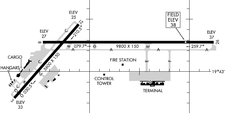
Hilo International Airport (IATA: ITO, ICAO: PHTO), formerly General Lyman Field, is owned and operated by the HawaiÊ»i State Department of Transportation. Located in Hilo, HawaiÊ»i County, the airport encompasses 1,391 acres and is one of two major airports on HawaiÊ»i Island and one of five major airports in the state. Hilo International Airport serves most of East HawaiÊ»i, including the districts of Hilo and Puna, as well as portions of the districts of HÄmÄkua and Kaʻū. Most flights to the airport are from Honolulu International Airport by Hawaiian Airlines and go! Mokulele. HistoryInitial developmentIn 1927 the Territory of Hawaii legislature passed Act 257, authorizing the expenditure of $25,000 for the construction of a landing strip in Hilo. The site was known as Keaukaha, on land belonging to the Hawaiian Homes Commission. Inmates from a nearby prison camp cleared the area of brush and rocks. The new facility was dedicated on February 11, 1928, by Major Clarence M. Young, then Secretary of Aeronautics of the U.S. Department of Commerce. Sixteen months after the dedication, scheduled inter-island service began on November 11, 1929 by Inter-Island Airways, the forerunner of Hawaiian Airlines. For $32, travelers could climb aboard an eight passenger Sikorsky S-38 on thrice weekly flights between Hilo and Honolulu. Five years later, in 1934, the company was awarded the right to carry air mail for the U.S. Postal Service. Early expansionImprovements to Hilo's airfield were minimal during its first decade. Between 1927 and 1937, just over $34,000 was spent in developing the site. Over the next five years, however, the Works Progress Administration spent $261,613 to upgrade the airport. An additional $314,000 was provided by the Civil Aeronautics Administration in 1941. During martial law in the territory following the attack on Pearl Harbor, all airports in the Hawaiian Islands came under the control of the U.S. military. The Army Engineers continued to expand the airport. In addition to military facilities to support an Air Corp fighter squadron at Hilo, the Army expanded and improved runways, taxiways and aprons. On April 19, 1943, the Territorial Legislature renamed Hilo Airport "General Lyman Field", for General Albert KualiÊ»i Brickwood Lyman (1885â1942), the first U.S. General of Hawaiian ancestry. He was one of three sons of Rufus Anderson Lyman to attend the United States Military Academy. The end of the war did not immediately bring about a return to civilian control of General Lyman Field. Although ownership of the airport was returned to the territory in September 1946, the Air Force leased the facilities and retained operational control of its tower for over three years after Japanâs surrender. Meanwhile, Trans-Pacific Airlines, later renamed Aloha Airlines, commenced inter-island flights on July 26, 1946. On April 8, 1952, the territory assumed full control, paving the way for another round of expansion. A groundbreaking ceremony for a new terminal building was held on July 17, 1952. At the same time, new high intensity lights were installed on Runway 8-26. Plans included a new freight terminal, aprons, parking areas and roads. The airport's new passenger terminal was completed and dedicated on December 5, 1953, and its freight terminal in June 1954. Overseas growthDuring the late 1950s Territorial leaders anticipated a boom in tourism, prompting plans for a second airport capable of accommodating large jet aircraft. The HawaiÊ»i Aeronautics Commission recommended that General Lyman Field be expanded for overseas flights. In April 1958, the territory acquired 91.6 acres (37.1 ha) on the eastern edge of the airport for a longer runway to enable non-stop flights to the west coast of the United States. The first phase was completed by April 1963 and a dedication ceremony for the 9,800 feet (3,000 m) runway was held on March 6, 1965. Two years later, in April 1967, the state finished new taxiways and aprons, finally allowing the airport to receive overseas flights. On October 1, 1967, United Airlines and Pan American World Airways inaugurated overseas service to Hilo. Work began on an interim overseas terminal at General Lyman Field in November 1968. With a price tag of $775,000, this facility was designed for the burgeoning number of overseas passengers until a new terminal complex could be built. It was dedicated on July 4, 1969. The following year, Governor John Burns appointed the Hilo Airport Advisory Committee to make recommendations on long term development of the airport. They suggested relocating terminals from the western edge of Runway 3-21 to the south of the newly lengthened Runway 8-26. The new terminal was designed for the largest passenger airliner in service: the Boeing 747. The airlines, however, did not wait until the new terminal was built; on February 6, 1971, the first jumbo jet landed: a Braniff International Airways B-747. Groundbreaking for a new terminal was held in July 1974. Construction of the terminal was done in two phases. The first was completed in 1975 and work immediately commenced on phase two. On April 30, 1976, officials dedicated the new, much more modern facility. In order to better serve the airport and its lengthened runway, the FAA opened a new, taller air traffic control tower on November 2, 1979. Overseas retrenchmentThe introduction of overseas service to General Lyman Field initially met with success. Joining United Airlines and Pan American Airways in providing nonstop service to Hilo from the west coast of the U.S. were Braniff, Continental, Northwest Orient, and Western Airlines. The number of overseas passengers flying through Hilo peaked at 313,428 in 1971 and remained between 250,000 and 300,000 for most of the decade. Beginning in 1979, however, overseas passenger traffic began to fall steadily, leading one carrier after another to suspend service to Hilo. By the mid-1980s overseas traffic had fallen by such an extent that United Airlines, the sole remaining overseas carrier, terminated scheduled service on December 1, 1986. The number of overseas passengers travelling to Hilo had declined in each of the previous eight years. During the first eleven months of 1986, United Airlines had served a mere 20,914 passengers in Hilo. Hilo would be left without a direct connection to North America for nearly two decades. At the same time, the state's other major airports added overseas service. United Airlines commenced service to Kahului Airport on January 5, 1983, followed by service to Kona International Airport on September 7 and finally to LÄ«huÊ»e Airport in August 1984. Hilo struggled to attract another overseas air carrier. In May 1989, the state Legislature renamed General Lyman Field to "Hilo International Airport". Among the reasons given were to reorient the airportâs image and to "conform to the practice of naming airports for their geographical locations". The main terminal kept the Lyman name. Efforts finally had some success on April 28, 2006 when ATA Airlines re-established daily non-stop service between Hilo and Oakland International Airport in California aboard its Boeing 737-800 aircraft. ATA Airlines' inauguration of direct overseas service to Hilo for the first time in nearly two decades was met with great fanfare and proved so successful the airline eventually substituted the larger Boeing 757-200 on its flights to Hilo during the peak travelling season around August. Just shy of two years later on April 2, 2008, ATA Airlines ceased operations, citing the cancellation of an agreement by FedEx that provided most of the company's charter flights, and the unprecedented increase in fuel prices. The demise of ATA Airlines left Hilo without overseas service once again. In the wake of ATA's bankruptcy, the Hawaii Tribune-Herald reported an undisclosed major U.S. Airline was considering service to Hilo. FacilitiesRunwaysHilo International Airport has two runways. Runway 8-26 is 9,800 ft à 150 ft (2,987 m à 46 m) and is used for nearly all air carrier operations. It is capable of accommodating overseas passenger service by aircraft as large as the Boeing 747 and is used occasionally by the Lockheed C-5 Galaxy, a military transport. Runway 3/21 is 5,600 ft à 150 ft (1,707 m à 46 m) and is used for general aviation operations including take-off and landing of smaller commuter airplanes. Terminal AreaThe passenger terminal complex, including commuter facilities; is at the southern edge of Hilo International Airport and is served by an access roadway from Hawaii Belt Road at KekÅ«anaÅÊ»a Avenue. Air Cargo operations are handled at the former passenger terminal, located on the western edge of Runway 3-21. The Northwest Apron, serves this area of the airport, provides parking for transient military aircraft and is the site of some general aviation facilities. Other general aviation facilities are located to the south, near the Civil Air Patrol area. Air Carrier Passenger TerminalThe main passenger terminal consists of three interconnected buildings totalling approximately 220,000 square feet (20,000 m). The central building consists of just under 120,000 square feet (11,000 m) of space while the western and eastern wings occupy slightly more than 50,000 square feet (4,600 m) each. The apron fronting the passenger terminal has ten aircraft parking positions, each able to accommodate a Boeing 747. Only eight of the positions are usable; two are used to provide eleven helicopter parking positions and there are just seven passenger loading bridges. Commuter TerminalThe commuter terminal is located in a small, stand alone building approximately 0.25 miles (0.40 km) to the west of the main passenger terminal. Safari Aviation, a helicopter tour company, currently leases the 4,040 square feet (375 m) building. Other aerial tour companies lease space in the western wing of General Lyman Terminal. Airlines and destinations
Issues facing Hilo International AirportUnderutilizationAlthough designed as the second gateway into and out of HawaiÊ»i, Hilo is HawaiÊ»i's only major airport lacking non-stop flights to North America. Today, Hilo International Airport is the smallest of the state's five major airports in terms of passenger arrivals and departures. Kona Airport and LÄ«huÊ»e Airport generally serve twice as many passengers as Hilo, while Maui's Kahului Airport typically sees four times as many travelers. Moreover, while other airports grew significantly over the past several decades, Hilo International Airport has seen little long-term increase in air traffic. In 1973, for example, the total passenger count at Hilo International Airport was 1,357,818. In 2008, that number stood at 1,352,808. Total traffic at Hilo peaked in 1997 with 1,669,314 people. An almost identical number of passengers, 1,667,163, passed through the airport in 2007. As a result, Hilo International Airport operates considerably below its capacity. The primary reason for Hilo International Airport's relatively stagnant passenger count is the lack of tourism within the airport's service area, which includes the districts of Hilo and Puna, as well as portions of the districts of HÄmÄkua and Kaʻū, relative to the Kona district and Kohala district and the islands of KauaÊ»i and Maui. In 2008, visitor hotel rooms and condominiums on HawaiÊ»i island totaled 11,240 units. Of these, 9,576 (85.2%) were in the districts of Kona and Kohala. A mere 1,635 (14.5%) were within the districts of HÄmÄkua, Hilo, and Puna. In 2008, the respective numbers of visitor accommodations on Maui and KauaÊ»i were 19,055 and 9,203. In fact, whereas the number of visitor accommodations elsewhere in the state climbed steadily since the 1970s, in east HawaiÊ»i island several hotels have been shuttered or converted into apartments or condominiums. NoiseHilo International Airport's proximity to residential areas has made noise abatement a persistent concern in the airport's development and operations. Exacerbating the impact of airport activity on nearby residential neighbourhoods is the fact that Hilo's climate favours single wall, open air construction to take advantage of natural ventilation provided by trade winds. This results in minimal outdoor to indoor noise attenuation. Complaints about airport noise have been received from locations including downtown Hilo, hotels and condominiums along Banyan Drive, and Keaukaha. In response, the HawaiÊ»i State Department of Transportation implemented measures designed to mitigate airport noise. Over 95% of aircraft operations take place on Runway 8-26 because the orientation of Runway 3-21 makes direct flights over residential and commercial areas unavoidable. Night and early morning flights are directed to arrive from and depart towards the east, where largely vacant land acts as a noise buffer. Day flights maintain a west to east pattern. Although this results in arriving aircraft coming closer to the downtown area, pilots attempt to remain over Hilo Bay for as long as possible before aligning their aircraft with the runway, crossing over near the Hilo Iron Works building. Also, aircraft landings are quieter than take-offs. All aircraft, in fact, are directed to avoid overflying residential and commercial areas to the extent possible. In addition, the U.S. military transferred some of its training activities to Kona International Airport and banned touch-and-go operations at Hilo entirely. Other proposed noise mitigation measures include a barrier on the north side of the airport and the extension of Runway 8-26 by 1,850 feet (560 m) to the east and displacing the western end of the runway by the same amount, thereby maintaining the runway's length. Community opposition to the construction of a barrier led the State to abandon the idea. It remains unclear if the HawaiÊ»i State Department of Transportation will move forward on relocating Runway 8-26 east by 1,850 feet, especially given the 2009 demise of Aloha Airlines, whose older generation Boeing 737 fleet was considerably louder than Hawaiian Airlines' relatively recent Boeing 717s. IncidentsHilo International Airport was involved in one major air traffic incident that had caused air traffic controllers and federal emergency officials to be on emergency special alert. On April 28, 1988, an Aloha Airlines Boeing 737 operating Flight 243 from General Lyman Field (as Hilo International Airport was known then) to Honolulu International Airport carrying 89 passengers and 5 crew members experienced rapid decompression when an 18 feet (5.5 m) section of the fuselage roof and sides were torn from the airplane. One flight attendant was sucked out of the airplane and died. Several passengers sustained life-threatening injuries including instances of massive head wounds. The aircraft declared an emergency and landed at Kahului Airport on Maui with slight difficulty. Investigations of the incident concluded that the accident was caused by metal fatigue. The incident caused almost all major United States air carriers to retire their oldest airplane models. The above content comes from Wikipedia and is published under free licenses – click here to read more.
Runway InformationRunway 03/21
Runway 08/26
Radio Navigation Aids
Remarks
Based Aircraft
Major Carriers Serving This Airport
Most Popular Destinations
Most Popular Aircraft
Operational StatisticsTime Period: 2005-03-31 - 2006-03-30
Hilo International Airport Address: Hawaii County, HI Tel: 808-838-8600, 808-934-5801 Images
and information placed above are from We thank them for the data!
We don't guarantee the information is fresh and accurate. The data may
be wrong or outdated.
|
|||||||||||||||||||||||||||||||||||||||||||||||||||||||||||||||||||||||||||||||||||||||||||||||||||||||||||||||||||||||||||||||||||||||||||||||||||||||||||||||||||||||||||||||||||||||||||||||||||||||||||||||||||||||||||||||||||||||||||||||||||||||||||||||||||||||||||||||||||||||||||||||||||||||||||||||||||||||||||||||||||||||||||||||||||||||||||||||||||||||||||||||||||||||||||||||||||||||||||||||||||||||||||||||||||||

 |
|
Copyright 2004-2026 © by Airports-Worldwide.com, Vyshenskoho st. 36, Lviv 79010, Ukraine Legal Disclaimer |