|
|
| Hana Airport |
 |
| IATA: HNM â ICAO: PHHN â FAA LID: HNM |
| Summary |
| Airport type |
Public |
| Operator |
Hawaii Department of Transportation |
| Serves |
Hana, Hawaii |
| Elevation AMSL |
78 ft / 24 m |
| Coordinates |
20°47â²44â³N 156°00â²52â³W / 20.79556°N 156.01444°W / 20.79556; -156.01444 (Hana Airport)Coordinates: 20°47â²44â³N 156°00â²52â³W / 20.79556°N 156.01444°W / 20.79556; -156.01444 (Hana Airport) |
| Website |
hawaii.gov/hnm |
| Runways |
| Direction |
Length |
Surface |
| ft |
m |
| 8/26 |
3,606 |
1,099 |
Asphalt |
| Statistics (2007) |
| Aircraft operations |
7,171 |
| Source: Federal Aviation Administration |
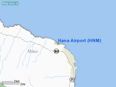
Hana Airport (IATA: HNM, ICAO: PHHN, FAA LID: HNM) is a regional airport of the State of Hawai'i on the east shore of the island of Maui, 3 NM (5.6 km; 3.5 mi) northwest of the unincorporated town of Hana. It is primarily a commuter facility used by unscheduled air taxis and general aviation. As air traffic increases, the Hawai'i State Legislature will consider future improvements including the construction of a taxiway paralleling the runway, widening of access roads and expansion of passenger terminals and parking facilities.
Scheduled commercial airline service provided Pacific Wings was subsidized by the Essential Air Service program until April 1, 2007, when Pacific Wings began providing subsidy free service. Facilities and aircraft
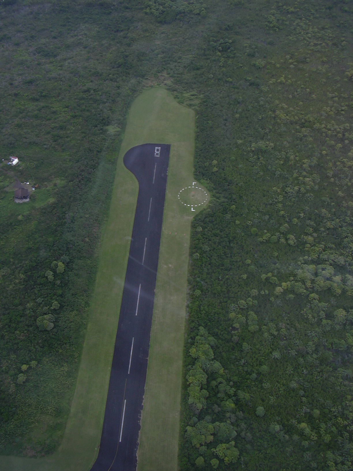
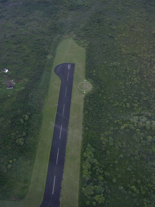
Hana Airport covers an area of 119 acres (48 ha) at an elevation of 78 feet (24 m) above mean sea level. It has one runway designated 8/26 with an asphalt surface measuring 3,606 by 100 feet (1,099 x 30 m).
For the 12-month period ending March 20, 2007, the airport had 7,171 aircraft operations, an average of 19 per day: 44% scheduled commercial, 33% air taxi, 22% general aviation, and <1% military.
Airlines and destinations
| Airlines |
Destinations |
| Pacific Wings |
Kahului |
Authority
Hana Airport is part of a centralized state structure governing all of the airports and seaports of Hawai'i. The official authority of Hana Airport is the Governor of Hawai'i. He or she appoints the Director of the Hawai'i State Department of Transportation who has jurisdiction over the Hawai'i Airports Administrator.
The Hawai'i Airports Administrator oversees six governing bodies: Airports Operations Office, Airports Planning Office, Engineering Branch, Information Technology Office, Staff Services Office, Visitor Information Program Office. Collectively, the six bodies have authority over the four airport districts in Hawai'i: Hawai'i District, Kaua'i District, Maui District and the principal O'ahu District. Hana Airport is a subordinate of the Maui District officials.
Media appearances
Hana Airport is the destination in the "Hawaiian Checkout" mission supplied with Microsoft Flight Simulator X.
The above content comes from Wikipedia and is published under free licenses – click here to read more.
Location
& QuickFacts
|
FAA
Information Effective: |
2007-07-05 |
|
Airport
Identifier: |
HNM |
|
Airport
Status: |
Operational |
|
Longitude/Latitude: |
156-00-51.9764W/20-47-44.2938N
-156.014438/20.795637 (Estimated) |
|
Elevation: |
78 ft / 23.77 m (Surveyed) |
|
Land: |
119 acres |
|
From
nearest city: |
3 nautical miles NW of Hana, HI |
|
Location: |
Maui County, HI |
|
Magnetic Variation: |
11E (1980) |
Owner
& Manager
|
Ownership: |
Publicly
owned |
|
Owner: |
Hawaii State Airports Div |
|
Address: |
400 Rodgers Blvd, Suite 700
Honolulu, HI 96819 |
|
Phone
number: |
808-838-8701 |
|
Manager: |
Roy Sakata
PEDRO OLIVEROS, ARPT OPNS/AOM/MAIN PHONE HANA 248-8208. |
|
Address: |
Kahului Arpt
Kahului, HI 96732 |
|
Phone number: |
808-872-3808 |
Airport
Operations and Facilities
|
Airport
Use: |
Open
to public |
|
Wind
indicator: |
Yes
WINDSOCK OTS INDEFLY. |
|
Segmented Circle: |
Yes |
|
Control
Tower: |
No |
|
Lighting
Schedule: |
DUSK-DAWN
ACTVT MIRL (ONLY HIGH INTST AVBL) RY 08/26 - CTAF. |
|
Beacon
Color: |
Clear-Green (lighted land airport) |
|
Landing
fee charge: |
No |
|
Sectional chart: |
Hawaiian Islands |
|
Region: |
AWP - Western-Pacific |
|
Boundary
ARTCC: |
ZHN - Honolulu Control Facility |
|
Tie-in
FSS: |
HNL - Honolulu |
|
FSS
on Airport: |
No |
|
FSS
Phone: |
808-836-8049 |
|
FSS
Toll Free: |
1-800-WX-BRIEF |
|
NOTAMs
Facility: |
HNM (NOTAM-d service avaliable) |
|
Certification type/date: |
III A S 07/20
INDEX "A", CLASS III, AOC ISSUED 7/29/2005 |
|
Federal Agreements: |
NGY |
Airport Communications
Airport
Services
|
Airframe
Repair: |
NONE |
|
Power
Plant Repair: |
NONE |
|
Bottled
Oxygen: |
NONE |
|
Bulk
Oxygen: |
NONE |
|
Runway Information
Runway 08/26
|
Dimension: |
3606
x 100 ft / 1099.1 x 30.5 m |
|
Surface: |
ASPH, Good Condition |
|
Weight
Limit: |
Single wheel: 34000 lbs.
Dual wheel: 48000 lbs.
Dual tandem wheel: 80000 lbs. |
|
Edge
Lights: |
Medium |
|
|
Runway 08 |
Runway 26 |
|
Longitude: |
156-01-10.9767W |
156-00-32.9760W |
|
Latitude: |
20-47-44.3085N |
20-47-44.2786N |
|
Elevation: |
78.00 ft |
53.00 ft |
|
Alignment: |
90 |
127 |
|
Traffic
Pattern: |
Left |
Right |
|
Markings: |
Basic, Good Condition |
Basic, Good Condition |
|
Crossing
Height: |
17.00 ft |
0.00 ft |
|
VASI: |
2-light PAPI on left side
RY 08 PAPI DALGT OPNS ONLY. RY
08 PAPI OTS INDEFLY. |
|
|
Visual
Glide Angle: |
2.75° |
0.00° |
|
Runway
End Identifier: |
No |
No |
|
Centerline
Lights: |
No |
No |
|
Touchdown
Lights: |
No |
No |
|
Radio Navigation
Aids
|
ID |
Type |
Name |
Ch |
Freq |
Var |
Dist |
|
VYI |
NDB |
Valley Island |
|
327.00 |
11E |
24.6 nm |
|
OGG |
VORTAC |
Maui |
098X |
115.10 |
11E |
23.8 nm |
|
UPP |
VORTAC |
Upolu Point |
070X |
112.30 |
11E |
37.0 nm |
Remarks
- LGTD
WIND SOCK LCTD RY 08 AND RY 26 END.
- 24
HRS PPR FOR CLASS A & B EXPLOSIVES AND 4 HRS PPR FOR OTHER HAZARDOUS
CARGO IN/OUT OF ARPT CTC (808) 872-3888.
- ARPT
CLSD TO HELICOPTERS SS-SR EXCEPT PPR (808) 872-3875.
- RY
08/26 35 FT TREES ALONG BOTH SIDES OF RY 200 FT FM CNTRLN.
- HELICOPTER
PILOT TRAINING MANEUVERS WILL BE CONDUCTED AT THE APCH END OF RY 26
ONLY.
- ULTRALIGHTS
ON AND INVOF ARPT.
- WILD
BOARS ON AND INVOF ARPT.
- HELICOPTER
PARKING ON GRASS AREA WEST OF WEST TWY.
- HELICOPTER
PARKING ON GRASS AREA WEST OF WEST TWY.
Based
Aircraft
|
Aircraft
based on field: |
1 |
|
Gliders: |
1 |
Operational Statistics
Time Period: 2006-03-20 - 2007-03-20
|
Aircraft
Operations: |
138/Week |
|
Commerical: |
44.2% |
|
Air
Taxi: |
33.4% |
|
General
Aviation Local: |
13.9% |
|
General
Aviation Itinerant: |
8.4% |
|
Military: |
0.1% |
Hana Airport
Address:
Maui County, HI
Tel:
808-838-8701,
808-872-3808
Images
and information placed above are from
http://www.airport-data.com/airport/HNM/
We
thank them for the data!
| General
Info |
| Country |
United
States |
| State |
HAWAII
|
| FAA ID |
HNM |
| Latitude |
20-47-44.294N
|
| Longitude |
156-00-51.976W
|
| Elevation |
78 feet
|
| Near City |
HANA |
We don't guarantee the information is fresh and accurate. The data may
be wrong or outdated.
For more up-to-date information please refer to other sources.
|
|