 |
|
Location
& QuickFacts
|
FAA Information Effective: |
2007-07-05 |
|
Airport
Identifier: |
GA23 |
|
Airport
Status: |
Operational |
|
Longitude/Latitude: |
085-23-02.0000W/34-34-42.0000N
-85.383889/34.578333 (Estimated) |
|
Elevation: |
720 ft / 219.46 m (Estimated) |
|
Land: |
30
acres |
|
From
nearest city: |
7 nautical miles SE of Summerville, GA |
|
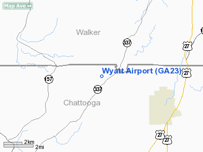
Location: |
Chattooga County, GA |
|
Magnetic Variation: |
02W (1995) |
Owner
& Manager
|
Ownership: |
Privately owned |
|
Owner: |
Greg Wyatt |
|
Address: |
905 York Road
Summerville, GA 30747 |
|
Phone number: |
706-734-0567
OWNER ADDITIONAL PHONE 706-857-3916. |
|
Manager: |
Greg Wyatt |
|
Address: |
905 York Road
Summerville, GA 30747 |
|
Phone number: |
706-734-0567
AMGR ADDITIONAL PHONE 706-857-3916. |
Airport
Operations and Facilities
|
Airport Use: |
Private |
|
Wind indicator: |
Yes |
|
Segmented Circle: |
No |
|
Control Tower: |
No |
|
Sectional chart: |
Atlanta |
|
Region: |
ASO - Southern |
|
Boundary ARTCC: |
ZTL - Atlanta |
|
Tie-in FSS: |
MCN - Macon |
|
FSS on Airport: |
No |
|
FSS Toll Free: |
1-800-WX-BRIEF |
Airport
Communications
|
Runway Information
Runway 02/20
|
Dimension: |
2750 x 150 ft / 838.2 x 45.7 m |
|
Surface: |
TURF, |
|
|
Runway 02 |
Runway 20 |
|
Traffic
Pattern: |
Right |
Left |
|
Obstruction: |
50 ft trees, 300.0 ft from runway |
5 ft fence, 50.0 ft from runway |
|
Radio Navigation
Aids
|
ID |
Type |
Name |
Ch |
Freq |
Var |
Dist |
|
FTP |
NDB |
Fort Payne |
|
426.00 |
01W |
14.7 nm |
|
OYD |
NDB |
Floyd |
|
388.00 |
02W |
20.0 nm |
|
OUK |
NDB |
Calhoun |
|
323.00 |
02W |
25.0 nm |
|
UWI |
NDB |
Whitfield |
|
400.00 |
03W |
25.1 nm |
|
APT |
NDB |
Jasper |
|
382.00 |
02W |
30.6 nm |
|
EVZ |
NDB |
Cartersville |
|
308.00 |
04W |
35.2 nm |
|
CQN |
NDB |
Daisy |
|
341.00 |
02W |
37.1 nm |
|
HDI |
NDB |
Hardwick |
|
369.00 |
01W |
41.9 nm |
|
UOS |
NDB |
Sewanee |
|
275.00 |
02E |
45.3 nm |
|
ARF |
NDB |
Saratoga |
|
296.00 |
02W |
46.0 nm |
|
JZP |
NDB |
Pickens County |
|
285.00 |
04W |
46.3 nm |
|
DJD |
NDB |
Canton |
|
415.00 |
04W |
48.6 nm |
|
BGF |
NDB |
Boiling Fork |
|
263.00 |
02W |
49.4 nm |
|
GQO |
VORTAC |
Choo Choo |
105X |
115.80 |
01E |
25.7 nm |
|
RMG |
VORTAC |
Rome |
101X |
115.40 |
01E |
28.2 nm |
Remarks
- DEPART
RY 02, LAND RY 20.
- PRVDD
VFR/PR USE.
Based
Aircraft
|
Aircraft
based on field: |
4 |
|
Single
Engine Airplanes: |
4 |
Wyatt Airport
Address:
Chattooga County, GA
Tel:
706-734-0567
Images
and information placed above are from
http://www.airport-data.com/airport/GA23/
We
thank them for the data!
| General
Info |
| Country |
United
States |
| State |
GEORGIA
|
| FAA ID |
GA23
|
| Latitude |
34-34-42.000N
|
| Longitude |
085-23-02.000W
|
| Elevation |
720 feet
|
| Near City |
SUMMERVILLE
|
We don't guarantee the information is fresh and accurate. The data may
be wrong or outdated.
For more up-to-date information please refer to other sources.
|
|


