 |
|
|
|
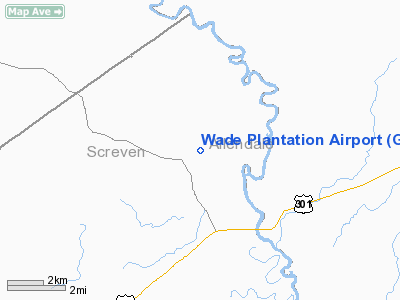
Location
& QuickFacts
|
FAA
Information Effective: |
2007-07-05 |
|
Airport
Identifier: |
GA88 |
|
Airport
Status: |
Operational |
|
Longitude/Latitude: |
081-32-10.3910W/32-58-37.5640N
-81.536220/32.977101 (Estimated) |
|
Elevation: |
146 ft / 44.50 m (Surveyed) |
|
Land: |
0 acres |
|
From
nearest city: |
15 nautical miles NE of Sylvania, GA |
|
Location: |
Screven County, GA |
|
Magnetic Variation: |
04W (1985) |
Owner
& Manager
|
Ownership: |
Privately
owned |
|
Owner: |
Morris |
|
Address: |
Wade Plantation Rr 1
Sylvania, GA 30467 |
|
Phone number: |
912-829-3391
OR 912-829-3392 |
|
Manager: |
Brigham Sanders |
|
Address: |
752 Oglethorpe Trail
Sylvania, GA 30467 |
|
Phone number: |
912-829-3391 |
Airport Operations and Facilities
|
Airport Use: |
Private |
|
Wind indicator: |
Yes |
|
Segmented Circle: |
No |
|
Control Tower: |
No |
|
Landing fee charge: |
No |
|
Sectional chart: |
Atlanta |
|
Region: |
ASO - Southern |
|
Boundary ARTCC: |
ZJX - Jacksonville |
|
Tie-in FSS: |
MCN - Macon |
|
FSS on Airport: |
No |
|
FSS Toll Free: |
1-800-WX-BRIEF |
|
NOTAMs Facility: |
MCN |
Airport Services
|
Airframe
Repair: |
NONE |
|
Power
Plant Repair: |
NONE |
|
Runway Information
Runway 17/35
|
Dimension: |
4500
x 175 ft / 1371.6 x 53.3 m |
|
Surface: |
TURF, |
|
|
Runway 17 |
Runway 35 |
|
Traffic
Pattern: |
Left |
Left |
|
Radio Navigation
Aids
|
ID |
Type |
Name |
Ch |
Freq |
Var |
Dist |
|
JYL |
NDB |
Sylvania |
|
245.00 |
04W |
19.9 nm |
|
LNH |
NDB |
Millen |
|
205.00 |
05W |
22.3 nm |
|
BKO |
NDB |
Barnwell |
|
392.00 |
06W |
22.9 nm |
|
BXG |
NDB |
Burke County |
|
356.00 |
04W |
23.9 nm |
|
BZ |
NDB |
Bullo |
|
407.00 |
05W |
34.4 nm |
|
EMR |
NDB |
Emory |
|
385.00 |
04W |
37.3 nm |
|
AIK |
NDB |
Aiken |
|
347.00 |
04W |
41.2 nm |
|
OYI |
NDB |
Orangeburg |
|
226.00 |
05W |
41.3 nm |
|
RBW |
NDB |
Walterboro |
|
221.00 |
05W |
45.3 nm |
|
MHP |
NDB |
Metter |
|
432.00 |
03W |
45.7 nm |
|
EEX |
NDB |
Emanuel County |
|
309.00 |
04W |
49.9 nm |
|
ALD |
VOR |
Allendale |
|
116.70 |
01W |
12.5 nm |
|
EDS |
VOR/DME |
Edisto |
051X |
111.40 |
05W |
44.6 nm |
Remarks
- ARPT
FOR EMERGENCY USE ONLY.
- EXISTED
PRIOR TO 1959.
Wade Plantation Airport
Address:
Screven County, GA
Tel:
912-829-3391, 912-829-3392
Images
and information placed above are from
http://www.airport-data.com/airport/GA88/
We
thank them for the data!
| General
Info |
| Country |
United
States |
| State |
GEORGIA
|
| FAA ID |
GA88
|
| Latitude |
32-58-37.564N
|
| Longitude |
081-32-10.391W
|
| Elevation |
146 feet
|
| Near City |
SYLVANIA
|
We don't guarantee the information is fresh and accurate. The data may
be wrong or outdated.
For more up-to-date information please refer to other sources.
|
|


