|
|
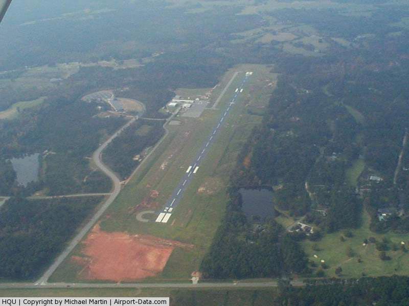
Thomson - Mcduffie County Airport |
|
 |
(Click on the photo to enlarge) |
Location
& QuickFacts
|
FAA Information Effective: |
2007-07-05 |
|
Airport
Identifier: |
HQU |
|
Airport
Status: |
Operational |
|
Longitude/Latitude: |
082-30-59.2720W/33-31-46.9680N
-82.516464/33.529713 (Estimated) |
|
Elevation: |
498 ft / 151.79 m (Estimated) |
|
Land: |
240 acres |
|
From
nearest city: |
4 nautical miles N of Thomson, GA |
|
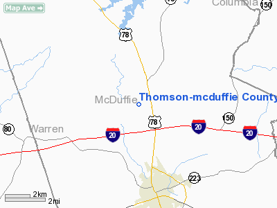
Location: |
Mc Duffie County, GA |
|
Magnetic Variation: |
04W (1995) |
Owner
& Manager
|
Ownership: |
Publicly owned |
|
Owner: |
Thomson City & Mcduffie Co |
|
Address: |
County Courthouse
Thomson, GA 30824 |
|
Phone
number: |
706-595-1781 |
|
Manager: |
Bob Flanders |
|
Address: |
454 John T. Lane Rd
Thomson, GA 30824 |
|
Phone number: |
706-595-1781 |
Airport
Operations and Facilities
|
Airport Use: |
Open to public |
|
Wind
indicator: |
Yes |
|
Segmented
Circle: |
Yes |
|
Control
Tower: |
No |
|
Lighting
Schedule: |
DUSK-DAWN
ACTVT MIRL RY 10/28, PAPIS RYS 10 AND 28 - CTAF. |
|
Beacon
Color: |
Clear-Green (lighted land airport) |
|
Landing
fee charge: |
No |
|
Sectional
chart: |
Atlanta |
|
Region: |
ASO - Southern |
|
Boundary
ARTCC: |
ZTL - Atlanta |
|
Tie-in
FSS: |
MCN - Macon |
|
FSS
on Airport: |
No |
|
FSS
Toll Free: |
1-800-WX-BRIEF |
|
NOTAMs
Facility: |
MCN (NOTAM-d service avaliable) |
|
Federal Agreements: |
NGY |
Airport
Communications
|
CTAF: |
122.800 |
|
Unicom: |
122.800 |
Airport
Services
|
Fuel available: |
100LLA |
|
Airframe Repair: |
MINOR |
|
Power Plant Repair: |
MINOR |
|
Bottled
Oxygen: |
LOW |
|
Bulk
Oxygen: |
NONE |
|
Runway Information
Runway 10/28
|
Dimension: |
5200 x 100 ft / 1585.0 x 30.5 m |
|
Surface: |
ASPH, Good Condition |
|
Weight
Limit: |
Single wheel: 30000 lbs.
Dual wheel: 50000 lbs.
Dual
tandem wheel: 87000 lbs. |
|
Edge
Lights: |
Medium |
|
|
Runway 10 |
Runway 28 |
|
Longitude: |
082-31-29.9520W |
082-30-28.5920W |
|
Latitude: |
33-31-48.1590N |
33-31-45.7760N |
|
Elevation: |
452.00
ft |
498.00
ft |
|
Alignment: |
93 |
127 |
|
ILS
Type: |
ILS |
|
|
Traffic
Pattern: |
Left |
Left |
|
Markings: |
Precision instrument, Good Condition |
Precision instrument, Good Condition |
|
Crossing
Height: |
52.00
ft |
28.00
ft |
|
Displaced
threshold: |
0.00 ft |
200.00
ft |
|
VASI: |
2-light PAPI on left side |
2-light PAPI on left side |
|
Visual
Glide Angle: |
3.00° |
3.00° |
|
Obstruction: |
23 ft trees, 407.0 ft from runway, 450 ft left
of centerline, 9:1 slope to clear
+10 FT TREES AND BRUSH 430' L AND 450' R OF THLD. |
55 ft pole, 2015.0 ft from runway, 490 ft left
of centerline, 33:1 slope to clear |
|
Radio Navigation
Aids
|
ID |
Type |
Name |
Ch |
Freq |
Var |
Dist |
|
HQU |
NDB |
Thomson-mcduffie |
|
333.00 |
04W |
0.1 nm |
|
AA |
NDB |
Cedar |
|
341.00 |
04W |
4.9 nm |
|
IIY |
NDB |
Washington/wilkes County |
|
435.00 |
03W |
20.9 nm |
|
VV |
NDB |
Junne |
|
353.00 |
05W |
26.2 nm |
|
EMR |
NDB |
Emory |
|
385.00 |
04W |
26.4 nm |
|
HIT |
NDB |
Kaolin |
|
360.00 |
05W |
37.4 nm |
|
BXG |
NDB |
Burke County |
|
356.00 |
04W |
39.0 nm |
|
UMB |
NDB |
Culvr |
|
380.00 |
04W |
39.5 nm |
|
AIK |
NDB |
Aiken |
|
347.00 |
04W |
42.7 nm |
|
BJT |
NDB |
Bulldog |
|
221.00 |
03W |
43.3 nm |
|
LNH |
NDB |
Millen |
|
205.00 |
05W |
47.1 nm |
|
GIW |
NDB |
Coronaca |
|
239.00 |
04W |
48.5 nm |
|
IRQ |
VORTAC |
Colliers |
086X |
113.90 |
04W |
20.7 nm |
|
GRD |
VORTAC |
Greenwood |
102X |
115.50 |
01W |
47.0 nm |
|
AHN |
VORTAC |
Athens |
33 |
109.60 |
00E |
47.6 nm |
Remarks
- DEER
ON RWY AT NIGHT.
- GCO
AVBL ON FREQ 121.725 THRU FLT SVCS.
Based
Aircraft
|
Aircraft
based on field: |
23 |
|
Single
Engine Airplanes: |
19 |
|
Multi
Engine Airplanes: |
2 |
|
Jet Engine
Airplanes: |
1 |
|
Helicopters: |
1 |
Operational Statistics
Time Period: 2005-04-12
- 2006-04-11
|
Aircraft
Operations: |
53/Day |
|
General
Aviation Local: |
52.6% |
|
General
Aviation Itinerant: |
47.4% |
Thomson-mcduffie County Airport
Address:
Mc Duffie County, GA
Tel:
706-595-1781
Images
and information placed above are from
http://www.airport-data.com/airport/HQU/
We
thank them for the data!
| General
Info |
| Country |
United
States |
| State |
GEORGIA
|
| FAA ID |
HQU
|
| Latitude |
33-31-46.968N
|
| Longitude |
082-30-59.272W
|
| Elevation |
498 feet
|
| Near City |
THOMSON
|
We don't guarantee the information is fresh and accurate. The data may
be wrong or outdated.
For more up-to-date information please refer to other sources.
|
|