 |
|
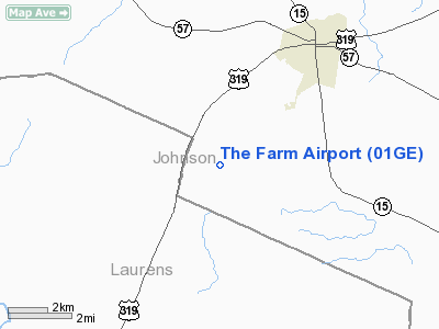
Location
& QuickFacts
|
FAA Information Effective: |
2007-07-05 |
|
Airport
Identifier: |
01GE |
|
Airport
Status: |
Operational |
|
Longitude/Latitude: |
082-46-16.0000W/32-40-28.0000N
-82.771111/32.674444 (Estimated) |
|
Elevation: |
375 ft / 114.30 m (Estimated) |
|
Land: |
0
acres |
|
From
nearest city: |
4 nautical miles SW of Wrightsville, GA |
|
Location: |
Johnson County, GA |
|
Magnetic Variation: |
() |
Owner
& Manager
|
Ownership: |
Privately owned |
|
Owner: |
William J. Johnson |
|
Address: |
Route 1 Box 503
Wrightsville, GA 31096 |
|
Phone number: |
478-864-7173 |
|
Manager: |
William J. Johnson |
|
Address: |
Route 1 Box 503
Wrightsville, GA 31096 |
|
Phone number: |
478-864-7173 |
Airport
Operations and Facilities
|
Airport Use: |
Private |
|
Control
Tower: |
No |
|
Sectional
chart: |
Atlanta |
|
Region: |
ASO - Southern |
|
Boundary
ARTCC: |
ZTL - Atlanta |
|
Responsible
ARTCC: |
ZTL - Atlanta |
|
Tie-in
FSS: |
MCN - Macon |
|
FSS
Toll Free: |
1-800-WX-BRIEF |
|
Runway Information
Runway 10/28
|
Dimension: |
2560 x 75 ft / 780.3 x 22.9 m |
|
Surface: |
TURF, |
|
|
Runway 10 |
Runway 28 |
|
Traffic
Pattern: |
Left |
Left |
|
Radio Navigation
Aids
|
ID |
Type |
Name |
Ch |
Freq |
Var |
Dist |
|
EEX |
NDB |
Emanuel County |
|
309.00 |
04W |
16.1 nm |
|
DB |
NDB |
Creke |
|
251.00 |
04W |
16.7 nm |
|
HIT |
NDB |
Kaolin |
|
360.00 |
05W |
22.3 nm |
|
UMB |
NDB |
Culvr |
|
380.00 |
04W |
34.8 nm |
|
MQW |
NDB |
Mc Rae |
|
280.00 |
03W |
35.3 nm |
|
UQN |
NDB |
Onyun |
|
372.00 |
04W |
36.2 nm |
|
EZM |
NDB |
Eastman |
|
366.00 |
04W |
37.8 nm |
|
MHP |
NDB |
Metter |
|
432.00 |
03W |
39.3 nm |
|
LNH |
NDB |
Millen |
|
205.00 |
05W |
42.7 nm |
|
BXG |
NDB |
Burke County |
|
356.00 |
04W |
44.6 nm |
|
AZE |
NDB |
Hazlehurst |
|
414.00 |
03W |
48.2 nm |
|
RVJ |
NDB |
Prison |
|
424.00 |
03W |
48.6 nm |
|
DBN |
VORTAC |
Dublin |
078X |
113.10 |
01W |
7.5 nm |
|
MCN |
VORTAC |
Macon |
089X |
114.20 |
01E |
44.3 nm |
|
VNA |
VORTAC |
Vienna |
112X |
116.50 |
01E |
46.1 nm |
Remarks
- PRVDD
VFR OPNS & PVT USE.
The Farm Airport
Address:
Johnson County, GA
Tel:
478-864-7173
Images
and information placed above are from
http://www.airport-data.com/airport/01GE/
We
thank them for the data!
We don't guarantee the information is fresh and accurate. The data may
be wrong or outdated.
For more up-to-date information please refer to other sources.
|
|


