|
|
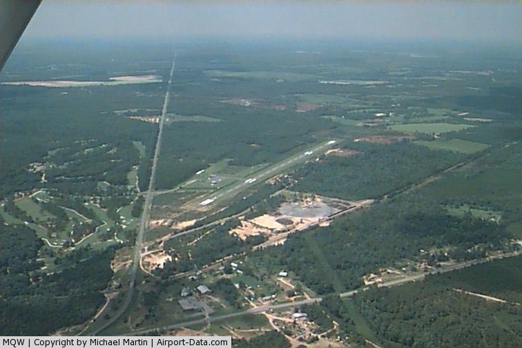
Telfair - Wheeler Airport |
|
 |
(Click on the photo to enlarge) |
Location
& QuickFacts
|
FAA Information Effective: |
2007-07-05 |
|
Airport
Identifier: |
MQW |
|
Airport
Status: |
Operational |
|
Longitude/Latitude: |
082-52-48.1000W/32-05-44.8000N
-82.880028/32.095778 (Estimated) |
|
Elevation: |
202 ft / 61.57 m (Surveyed) |
|
Land: |
104 acres |
|
From
nearest city: |
3 nautical miles NE of Mc Rae, GA |
|
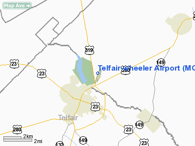
Location: |
Wheeler County, GA |
|
Magnetic Variation: |
03W (1985) |
Owner
& Manager
|
Ownership: |
Publicly owned |
|
Owner: |
Airport Authority
MC RAE, TELFAIR-WHEELER AIRPORT AUTHORITY. |
|
Address: |
Po Box 367
Mc Rae, GA 31055 |
|
Phone
number: |
912-868-6512 |
|
Manager: |
Embry Harrell
CHAIRMAN, ARPT AUTHORITY. |
|
Address: |
Po Box 485
Mc Rae, GA 31055 |
|
Phone number: |
912-868-2316 |
Airport
Operations and Facilities
|
Airport Use: |
Open to public |
|
Wind
indicator: |
Yes |
|
Segmented
Circle: |
Yes |
|
Control
Tower: |
No |
|
Lighting
Schedule: |
DUSK-DAWN
MIRL RY 03/21 OPER DUSK-2200; AFT 2200 ACTVT - CTAF. |
|
Beacon
Color: |
Clear-Green (lighted land airport) |
|
Landing
fee charge: |
No |
|
Sectional
chart: |
Atlanta |
|
Region: |
ASO - Southern |
|
Boundary
ARTCC: |
ZJX - Jacksonville |
|
Responsible
ARTCC: |
ZJX - Jacksonville |
|
Tie-in
FSS: |
MCN - Macon |
|
FSS
on Airport: |
No |
|
FSS
Toll Free: |
1-800-WX-BRIEF |
|
NOTAMs
Facility: |
MCN (NOTAM-d service avaliable) |
|
Federal Agreements: |
NY1 |
Airport
Communications
Airport
Services
|
Fuel available: |
100LL
FUEL AVBL WITH CREDIT CARD. |
|
Airframe Repair: |
NONE |
|
Power Plant Repair: |
NONE |
|
Bottled
Oxygen: |
NONE |
|
Bulk
Oxygen: |
NONE |
|
Runway Information
Runway 03/21
|
Dimension: |
4030 x 75 ft / 1228.3 x 22.9 m |
|
Surface: |
ASPH, Good Condition |
|
Weight
Limit: |
Single wheel: 30000 lbs. |
|
Edge
Lights: |
Medium |
|
|
Runway 03 |
Runway 21 |
|
Longitude: |
082-52-57.1363W |
082-52-38.9959W |
|
Latitude: |
32-05-26.3746N |
32-06-03.1461N |
|
Elevation: |
202.00
ft |
185.00
ft |
|
Alignment: |
23 |
127 |
|
Traffic
Pattern: |
Left |
Left |
|
Markings: |
Non-precision instrument, Poor Condition
RWY 03 - RWY MARKINGS BADLY DISCOLORED AND FADED. |
Non-precision instrument, Poor Condition
RY MARKINGS BADLY DISCOLORED AND FADED. |
|
Crossing
Height: |
34.00
ft |
39.00
ft |
|
VASI: |
2-light PAPI on left side |
2-light PAPI on left side |
|
Visual
Glide Angle: |
3.00° |
3.00° |
|
Obstruction: |
62 ft trees, 1130.0 ft from runway, 15:1 slope
to clear |
10 ft trees, 200.0 ft from runway, 120 ft right
of centerline
+10 FT TREES & BRUSH 115 FT R OF THLD, +20 FT TREES 122
FT L OF THLD. |
|
Radio Navigation
Aids
|
ID |
Type |
Name |
Ch |
Freq |
Var |
Dist |
|
MQW |
NDB |
Mc Rae |
|
280.00 |
03W |
0.2 nm |
|
EZM |
NDB |
Eastman |
|
366.00 |
04W |
14.1 nm |
|
AZE |
NDB |
Hazlehurst |
|
414.00 |
03W |
17.6 nm |
|
DB |
NDB |
Creke |
|
251.00 |
04W |
24.3 nm |
|
UQN |
NDB |
Onyun |
|
372.00 |
04W |
30.6 nm |
|
BHC |
NDB |
Baxley |
|
376.00 |
04W |
34.0 nm |
|
SUR |
NDB |
Fitzgerald |
|
362.00 |
03W |
35.8 nm |
|
RVJ |
NDB |
Prison |
|
424.00 |
03W |
37.1 nm |
|
EEX |
NDB |
Emanuel County |
|
309.00 |
04W |
40.6 nm |
|
OWC |
NDB |
Coffee County |
|
390.00 |
03W |
41.6 nm |
|
MHP |
NDB |
Metter |
|
432.00 |
03W |
43.8 nm |
|
BEP |
NDB |
Bay Creek |
|
350.00 |
03W |
50.0 nm |
|
DBN |
VORTAC |
Dublin |
078X |
113.10 |
01W |
28.0 nm |
|
VNA |
VORTAC |
Vienna |
112X |
116.50 |
01E |
32.2 nm |
|
AMG |
VORTAC |
Alma |
098X |
115.10 |
00E |
38.6 nm |
Based
Aircraft
|
Aircraft
based on field: |
9 |
|
Single
Engine Airplanes: |
8 |
|
Multi
Engine Airplanes: |
1 |
Operational Statistics
Time Period: 2005-02-07
- 2006-02-06
|
Aircraft
Operations: |
77/Week |
|
General
Aviation Local: |
50.0% |
|
General
Aviation Itinerant: |
50.0% |
Sunshine Farms Airport
Address:
Wheeler County, GA
Tel:
912-868-6512,
912-868-2316
Images
and information placed above are from
http://www.airport-data.com/airport/MQW/
We
thank them for the data!
| General
Info |
| Country |
United
States |
| State |
GEORGIA
|
| FAA ID |
MQW
|
| Latitude |
32-05-44.800N
|
| Longitude |
082-52-48.100W
|
| Elevation |
202 feet
|
| Near City |
MC RAE
|
We don't guarantee the information is fresh and accurate. The data may
be wrong or outdated.
For more up-to-date information please refer to other sources.
|
|