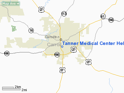
Tanner Medical Center Carrollton Heliport |
Location
& QuickFacts
|
FAA Information Effective: |
2007-07-05 |
|
Airport
Identifier: |
3GA2 |
|
Airport
Status: |
Operational |
|
Longitude/Latitude: |
085-04-29.8000W/33-34-12.3980N
-85.074944/33.570111 (Estimated) |
|
Elevation: |
1062 ft / 323.70 m (Estimated) |
|
Land: |
0
acres |
|
From
nearest city: |
0 nautical miles S of Carrollton, GA |
|
Location: |
Carroll County, GA |
|
Magnetic Variation: |
02W (1990) |
Owner
& Manager
|
Ownership: |
Publicly owned |
|
Owner: |
Tanner Medical Center |
|
Address: |
705 Dixie Street
Carrollton, GA 30117 |
|
Phone number: |
770-836-9666 |
|
Address: |
|
Airport
Operations and Facilities
|
Airport Use: |
Private
MEDICAL USE. |
|
Segmented
Circle: |
No |
|
Control
Tower: |
No |
|
Sectional
chart: |
Atlanta |
|
Region: |
ASO - Southern |
|
Boundary
ARTCC: |
ZTL - Atlanta |
|
Tie-in
FSS: |
MCN - Macon |
|
FSS
on Airport: |
No |
|
FSS
Toll Free: |
1-800-WX-BRIEF |
|
Runway Information
Helipad H1
|
Dimension: |
50 x 50 ft / 15.2 x 15.2 m |
|
Surface: |
ASPH, |
|
|
Runway H1 |
Runway |
|
Traffic
Pattern: |
Left |
Left |
|
Radio Navigation
Aids
|
ID |
Type |
Name |
Ch |
Freq |
Var |
Dist |
|
GPQ |
NDB |
Carrollton |
|
278.00 |
02W |
2.8 nm |
|
FT |
NDB |
Flanc |
|
344.00 |
02W |
24.7 nm |
|
EQQ |
NDB |
Coweta County |
|
234.00 |
03W |
26.2 nm |
|
FF |
NDB |
Pecat |
|
316.00 |
02W |
33.7 nm |
|
BR |
NDB |
Redan |
|
266.00 |
02W |
38.5 nm |
|
EVZ |
NDB |
Cartersville |
|
308.00 |
04W |
39.6 nm |
|
OYD |
NDB |
Floyd |
|
388.00 |
02W |
44.0 nm |
|
PIM |
NDB |
Pine Mountain |
|
272.00 |
03W |
44.9 nm |
|
JHH |
NDB |
Griffin |
|
412.00 |
04W |
48.4 nm |
|
DOB |
TACAN |
Dobbins |
077X |
|
01W |
35.1 nm |
|
PDK |
VOR/DME |
Peachtree |
113X |
116.60 |
02W |
42.9 nm |
|
TDG |
VOR/DME |
Talladega |
025X |
108.80 |
02E |
48.5 nm |
|
LGC |
VORTAC |
Lagrange |
103X |
115.60 |
01E |
32.0 nm |
|
ATL |
VORTAC |
Atlanta |
116X |
116.90 |
00W |
32.2 nm |
|
RMG |
VORTAC |
Rome |
101X |
115.40 |
01E |
35.7 nm |
|
ATL |
VOT |
Atlanta Muni |
|
111.00 |
|
32.9 nm |
Remarks
- PRVDD
VFR/PR USE; APCH/DEP RTES OPS FROM 150-190 DEGS; TKOF/LNDG AREA MKD;
WIND INDICATOR MNTND; PARKING LGTS SE LOWERED/REMOVED; & 7 PARKING
SPACES SOUTH OF PAD ARE REMOVED.
Based
Aircraft
|
Aircraft
based on field: |
3 |
|
Helicopters: |
3 |
Tanner Medical Center Carrollton Heliport
Address:
Carroll County, GA
Tel:
770-836-9666
Images
and information placed above are from
http://www.airport-data.com/airport/3GA2/
We
thank them for the data!
| General
Info |
| Country |
United
States |
| State |
GEORGIA
|
| FAA ID |
3GA2
|
| Latitude |
33-34-12.398N
|
| Longitude |
085-04-29.800W
|
| Elevation |
1062 feet
|
| Near City |
CARROLLTON
|
We don't guarantee the information is fresh and accurate. The data may
be wrong or outdated.
For more up-to-date information please refer to other sources.
|


