|
|
|
 |
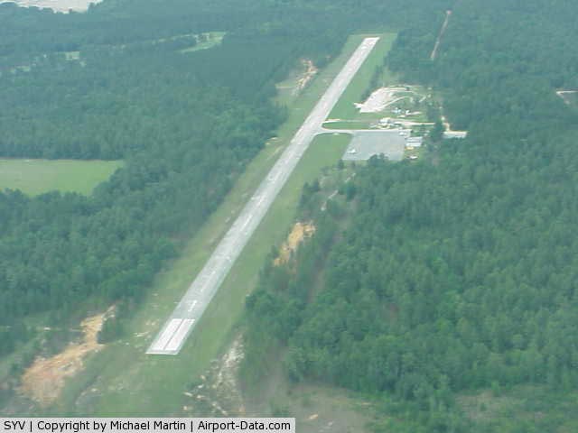
(Click on the photo to enlarge) |
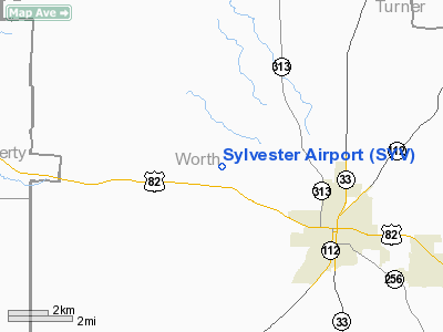
Location
& QuickFacts
|
FAA Information Effective: |
2007-07-05 |
|
Airport
Identifier: |
SYV |
|
Airport
Status: |
Operational |
|
Longitude/Latitude: |
083-53-44.6420W/31-33-30.6400N
-83.895734/31.558511 (Estimated) |
|
Elevation: |
403 ft / 122.83 m (Surveyed) |
|
Land: |
70
acres |
|
From
nearest city: |
3 nautical miles NW of Sylvester, GA |
|
Location: |
Worth County, GA |
|
Magnetic Variation: |
02W (1985) |
Owner
& Manager
|
Ownership: |
Publicly owned |
|
Owner: |
City Of Sylvester |
|
Address: |
101 North Main Street
Sylvester, GA 31791 |
|
Phone
number: |
229-776-8505 |
|
Manager: |
Tommy Bozeman |
|
Address: |
101 North Main Street
Sylvester, GA 31791 |
|
Phone number: |
229-776-8516 |
Airport
Operations and Facilities
|
Airport Use: |
Open to public |
|
Wind
indicator: |
Yes |
|
Segmented
Circle: |
Yes |
|
Control
Tower: |
No |
|
Lighting
Schedule: |
DUSK-DAWN
ACTVT MIRL RY 01/19 AND PAPI RYS 01 & 19 - CTAF. |
|
Beacon
Color: |
Clear-Green (lighted land airport) |
|
Landing
fee charge: |
No |
|
Sectional
chart: |
Jacksonville |
|
Region: |
ASO - Southern |
|
Boundary
ARTCC: |
ZJX - Jacksonville |
|
Tie-in
FSS: |
MCN - Macon |
|
FSS
on Airport: |
No |
|
FSS
Toll Free: |
1-800-WX-BRIEF |
|
NOTAMs
Facility: |
MCN (NOTAM-d service avaliable) |
|
Federal Agreements: |
NY1 |
Airport
Communications
|
CTAF: |
122.800 |
|
Unicom: |
122.800 |
Airport
Services
|
Bottled
Oxygen: |
NONE |
|
Bulk
Oxygen: |
NONE |
|
Runway Information
Runway 01/19
|
Dimension: |
3293
x 75 ft / 1003.7 x 22.9 m
55 FT. BLAST PAD ADDED TO RUNWAY 01; 52 FT. BLAST PAD ADDEDTO RUNWAY 19; RESULTING RUNWAY LENGTH
IS 3293 FEET. |
|
Surface: |
ASPH, Fair Condition |
|
Weight
Limit: |
Single wheel: 26000 lbs. |
|
Edge
Lights: |
Medium |
|
|
Runway 01 |
Runway 19 |
|
Traffic
Pattern: |
Left |
Left |
|
Markings: |
Basic, Fair Condition |
Basic, Poor Condition
RY MARKINGS BADLY FADED. |
|
VASI: |
2-light PAPI on left side |
2-light PAPI on left side |
|
Obstruction: |
, 50:1 slope to clear |
19 ft trees, 580.0 ft from runway, 160 ft right
of centerline, 20:1 slope to clear
+12 FT TREES & BRUSH 155 FT FM THLD AND 90 FT R. ADDNL
TREES & BRUSH 123 FT RIGHT OF THLD OUT TO 200 FEET. |
|
Radio Navigation
Aids
|
ID |
Type |
Name |
Ch |
Freq |
Var |
Dist |
|
AB |
NDB |
Putny |
|
227.00 |
02W |
20.4 nm |
|
TM |
NDB |
Tifto |
|
409.00 |
03W |
26.0 nm |
|
OHY |
NDB |
Coney |
|
400.00 |
02W |
26.5 nm |
|
CXU |
NDB |
Camilla |
|
369.00 |
02W |
27.1 nm |
|
SUR |
NDB |
Fitzgerald |
|
362.00 |
03W |
31.2 nm |
|
GTP |
NDB |
Patten |
|
245.00 |
02W |
36.3 nm |
|
LKG |
NDB |
Lindbergh |
|
242.00 |
03W |
38.6 nm |
|
CYR |
NDB |
Caidy |
|
338.00 |
01W |
42.5 nm |
|
IWJ |
NDB |
Blaak |
|
344.00 |
03W |
47.7 nm |
|
LYZ |
NDB |
Willis |
|
359.00 |
01W |
47.8 nm |
|
IZS |
NDB |
Montezuma |
|
426.00 |
04W |
49.0 nm |
|
IFM |
VOR |
Tift Myers |
|
112.50 |
01W |
22.3 nm |
|
MGR |
VOR/DME |
Moultrie |
025X |
108.80 |
02W |
29.0 nm |
|
PZD |
VORTAC |
Pecan |
108X |
116.10 |
02W |
21.2 nm |
|
VNA |
VORTAC |
Vienna |
112X |
116.50 |
01E |
44.3 nm |
Based Aircraft
|
Aircraft
based on field: |
1 |
|
Single
Engine Airplanes: |
1 |
Operational Statistics
Time Period: 2006-04-12
- 2007-04-11
|
Aircraft
Operations: |
39/Week |
|
General
Aviation Local: |
50.0% |
|
General
Aviation Itinerant: |
50.0% |
Sylvester Airport
Address:
Worth County, GA
Tel:
229-776-8505,
229-776-8516
Images
and information placed above are from
http://www.airport-data.com/airport/SYV/
We
thank them for the data!
| General
Info |
| Country |
United
States |
| State |
GEORGIA
|
| FAA ID |
SYV
|
| Latitude |
31-33-30.640N
|
| Longitude |
083-53-44.642W
|
| Elevation |
403 feet
|
| Near City |
SYLVESTER
|
We don't guarantee the information is fresh and accurate. The data may
be wrong or outdated.
For more up-to-date information please refer to other sources.
|
|