 |
|
|
 |
(Click on the photo to enlarge) |
Location
& QuickFacts
|
FAA Information Effective: |
2007-07-05 |
|
Airport
Identifier: |
20GA |
|
Airport
Status: |
Operational |
|
Longitude/Latitude: |
084-53-04.7850W/33-45-23.3850N
-84.884662/33.756496 (Estimated) |
|
Elevation: |
1110 ft / 338.33 m (Estimated) |
|
Land: |
155 acres |
|
From
nearest city: |
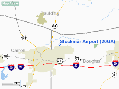
2 nautical miles NE of Villa Rica, GA |
|
Location: |
Douglas County, GA |
|
Magnetic Variation: |
03W (2000) |
Owner
& Manager
|
Ownership: |
Privately owned |
|
Owner: |
Dodgie Stockmar |
|
Address: |
P.o. Box 880
Villa Rica, GA 30180 |
|
Phone
number: |
770-459-5145 |
|
Manager: |
Dodgie Stockmar |
|
Address: |
P.o. Box 880
Villa Rica, GA 30180 |
|
Phone number: |
770-459-5145 |
Airport
Operations and Facilities
|
Airport Use: |
Private |
|
Wind
indicator: |
Yes |
|
Segmented
Circle: |
No |
|
Control
Tower: |
No |
|
Lighting
Schedule: |
PHONE REQ
FOR LIRL RY 10/28 CALL (770) 459-5145. |
|
Landing fee charge: |
No |
|
Sectional chart: |
Atlanta |
|
Region: |
ASO - Southern |
|
Traffic Pattern Alt: |
720 ft |
|
Boundary ARTCC: |
ZTL - Atlanta |
|
Tie-in FSS: |
MCN - Macon |
|
FSS on Airport: |
No |
|
FSS Toll Free: |
1-800-WX-BRIEF |
Airport
Services
|
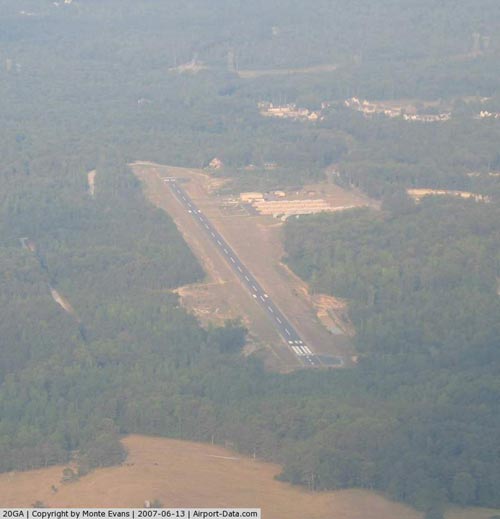
Runway Information
Runway 10/28
|
Dimension: |
4300 x 24 ft / 1310.6 x 7.3 m |
|
Surface: |
ASPH, |
|
Edge
Lights: |
Non-standard lighting system
NSTD LIRL; ONLY THE FIRST 2000 FT OF RY 10 ARE LGTD. |
|
|
Runway 10 |
Runway 28 |
|
Traffic
Pattern: |
Left |
Left |
|
Radio Navigation
Aids
|
ID |
Type |
Name |
Ch |
Freq |
Var |
Dist |
|
FT |
NDB |
Flanc |
|
344.00 |
02W |
12.3 nm |
|
GPQ |
NDB |
Carrollton |
|
278.00 |
02W |
16.8 nm |
|
EVZ |
NDB |
Cartersville |
|
308.00 |
04W |
26.7 nm |
|
BR |
NDB |
Redan |
|
266.00 |
02W |
29.4 nm |
|
EQQ |
NDB |
Coweta County |
|
234.00 |
03W |
31.2 nm |
|
FF |
NDB |
Pecat |
|
316.00 |
02W |
33.9 nm |
|
OYD |
NDB |
Floyd |
|
388.00 |
02W |
35.4 nm |
|
DJD |
NDB |
Canton |
|
415.00 |
04W |
35.8 nm |
|
OUK |
NDB |
Calhoun |
|
323.00 |
02W |
38.8 nm |
|
JZP |
NDB |
Pickens County |
|
285.00 |
04W |
47.1 nm |
|
JHH |
NDB |
Griffin |
|
412.00 |
04W |
47.6 nm |
|
DOB |
TACAN |
Dobbins |
077X |
|
01W |
21.1 nm |
|
PDK |
VOR/DME |
Peachtree |
113X |
116.60 |
02W |
30.1 nm |
|
ATL |
VORTAC |
Atlanta |
116X |
116.90 |
00W |
23.8 nm |
|
RMG |
VORTAC |
Rome |
101X |
115.40 |
01E |
27.1 nm |
|
LGC |
VORTAC |
Lagrange |
103X |
115.60 |
01E |
45.5 nm |
|
ATL |
VOT |
Atlanta Muni |
|
111.00 |
|
23.7 nm |
Remarks
- TRANSIENT
ACFT MUST OBTAIN WRITTEN PERMISSION FROM OWNER BEFORE LANDING AT OWN
RISK.
- VFR,
PVT USE ONLY.
Based
Aircraft
|
Aircraft
based on field: |
27 |
|
Single
Engine Airplanes: |
26 |
|
Multi
Engine Airplanes: |
1 |
Stockmar Airport
Address:
Douglas County, GA
Tel:
770-459-5145
Images
and information placed above are from
http://www.airport-data.com/airport/20GA/
We
thank them for the data!
| General
Info |
| Country |
United
States |
| State |
GEORGIA
|
| FAA ID |
20GA
|
| Latitude |
33-45-23.385N
|
| Longitude |
084-53-04.785W
|
| Elevation |
1110 feet
|
| Near City |
VILLA
RICA |
We don't guarantee the information is fresh and accurate. The data may
be wrong or outdated.
For more up-to-date information please refer to other sources.
|
|


