 |
|
|
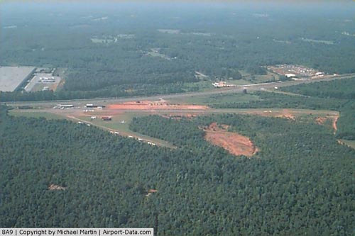 |
(Click on the photo to enlarge) |
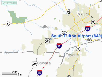
Location
& QuickFacts
|
FAA Information Effective: |
2007-07-05 |
|
Airport
Identifier: |
8A9 |
|
Airport
Status: |
Operational |
|
Longitude/Latitude: |
084-38-19.7540W/33-32-15.4040N
-84.638821/33.537612 (Estimated) |
|
Elevation: |
1025 ft / 312.42 m (Estimated) |
|
Land: |
475 acres |
|
From
nearest city: |
3 nautical miles SW of Palmetto, GA |
|
Location: |
Fulton County, GA |
|
Magnetic Variation: |
02W (1985) |
Owner
& Manager
|
Ownership: |
Privately owned |
|
Owner: |
Lynn Gause |
|
Address: |
7775 Roosevelt Hwy
Palmetto, GA 30268 |
|
Phone number: |
770-943-2679 |
|
Manager: |
Lynn Gause |
|
Address: |
7775 Roosevelt Hwy
Palmetto, GA 30268 |
|
Phone number: |
770-422-5331 |
Airport
Operations and Facilities
|
Airport Use: |
Open to public |
|
Wind
indicator: |
Yes |
|
Segmented
Circle: |
No |
|
Control
Tower: |
No |
|
Landing
fee charge: |
No |
|
Sectional
chart: |
Atlanta |
|
Region: |
ASO - Southern |
|
Boundary
ARTCC: |
ZTL - Atlanta |
|
Tie-in
FSS: |
MCN - Macon |
|
FSS
on Airport: |
No |
|
FSS
Toll Free: |
1-800-WX-BRIEF |
|
NOTAMs
Facility: |
MCN (NOTAM-d service avaliable) |
Airport
Communications
|
CTAF: |
123.000 |
|
Unicom: |
123.000 |
Airport
Services
|
Fuel available: |
100LL |
|
Airframe Repair: |
MAJOR |
|
Power Plant Repair: |
MAJOR |
|
Bottled
Oxygen: |
NONE |
|
Bulk
Oxygen: |
NONE |
|
Runway Information
Runway 09/27
|
Dimension: |
2690 x 40 ft / 819.9 x 12.2 m |
|
Surface: |
ASPH, Poor Condition
EXTENSIVE CRACKING THROUGHOUT PAVED AREAS. |
|
Weight
Limit: |
Single wheel: 5000 lbs. |
|
|
Runway 09 |
Runway 27 |
|
Traffic
Pattern: |
Left |
Left |
|
Markings: |
Basic, Fair Condition |
Basic, Fair Condition |
|
Displaced
threshold: |
600.00
ft |
600.00
ft |
|
Obstruction: |
15 ft tree, 200.0 ft from runway, 75 ft left
of centerline
RY 09 APCH RATIO 0:1 TO DSPLCD THLD.
RY 09 HAS 15 FT TREES & BRUSH AT THLD, 88 FT LEFT &
110 FT RIGHT.. |
65 ft trees, 200.0 ft from runway
RY 27 APCH RATIO 0:1 TO DSPLCD THLD. +20 FT BLDG AT THLD 100
FT LEFT.
RY 27 HAS +15 FT TREES AND BRUSH AT THLD. |
|
Radio Navigation
Aids
|
ID |
Type |
Name |
Ch |
Freq |
Var |
Dist |
|
FT |
NDB |
Flanc |
|
344.00 |
02W |
13.5 nm |
|
FF |
NDB |
Pecat |
|
316.00 |
02W |
16.2 nm |
|
EQQ |
NDB |
Coweta County |
|
234.00 |
03W |
17.3 nm |
|
BR |
NDB |
Redan |
|
266.00 |
02W |
17.6 nm |
|
GPQ |
NDB |
Carrollton |
|
278.00 |
02W |
24.7 nm |
|
JHH |
NDB |
Griffin |
|
412.00 |
04W |
29.6 nm |
|
EVZ |
NDB |
Cartersville |
|
308.00 |
04W |
41.1 nm |
|
VOF |
NDB |
Alcovy |
|
370.00 |
03W |
43.3 nm |
|
PIM |
NDB |
Pine Mountain |
|
272.00 |
03W |
43.4 nm |
|
OP |
NDB |
Yates |
|
339.00 |
03W |
43.6 nm |
|
DJD |
NDB |
Canton |
|
415.00 |
04W |
43.6 nm |
|
JNM |
NDB |
Monroe |
|
392.00 |
03W |
47.2 nm |
|
DOB |
TACAN |
Dobbins |
077X |
|
01W |
23.6 nm |
|
PDK |
VOR/DME |
Peachtree |
113X |
116.60 |
02W |
26.5 nm |
|
ATL |
VORTAC |
Atlanta |
116X |
116.90 |
00W |
11.6 nm |
|
LGC |
VORTAC |
Lagrange |
103X |
115.60 |
01E |
40.9 nm |
|
RMG |
VORTAC |
Rome |
101X |
115.40 |
01E |
44.6 nm |
|
ATL |
VOT |
Atlanta Muni |
|
111.00 |
|
12.9 nm |
Remarks
Based
Aircraft
|
Aircraft
based on field: |
37 |
|
Single
Engine Airplanes: |
35 |
|
Multi
Engine Airplanes: |
1 |
|
Ultralights: |
1 |
Operational Statistics
Time Period: 1998-02-05
- 1999-02-04
|
Aircraft
Operations: |
193/Week |
|
General
Aviation Local: |
90.0% |
|
General
Aviation Itinerant: |
10.0% |
South Fulton Airport
Address:
Fulton County, GA
Tel:
770-943-2679, 770-422-5331
Images
and information placed above are from
http://www.airport-data.com/airport/8A9/
We
thank them for the data!
| General
Info |
| Country |
United
States |
| State |
GEORGIA
|
| FAA ID |
8A9
|
| Latitude |
33-32-15.404N
|
| Longitude |
084-38-19.754W
|
| Elevation |
1025 feet
|
| Near City |
PALMETTO
|
We don't guarantee the information is fresh and accurate. The data may
be wrong or outdated.
For more up-to-date information please refer to other sources.
|
|


