 |
|
|
|
|
|
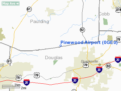
Location
& QuickFacts
|
FAA Information Effective: |
2007-07-05 |
|
Airport
Identifier: |
0GE0 |
|
Airport
Status: |
Operational |
|
Longitude/Latitude: |
084-48-02.7750W/33-46-55.3840N
-84.800771/33.782051 (Estimated) |
|
Elevation: |
1085 ft / 330.71 m (Surveyed) |
|
Land: |
10
acres |
|
From
nearest city: |
3 nautical miles NW of Douglasville, GA |
|
Location: |
Paulding County, GA |
|
Magnetic Variation: |
02W (1985) |
Owner
& Manager
|
Ownership: |
Privately owned |
|
Owner: |
Mark Bagwell & Bob Meadows |
|
Address: |
544 Jack Meadows Road
Douglasville, GA 30134 |
|
Phone
number: |
770-949-9635 |
|
Manager: |
Bob Meadows |
|
Address: |
544 Jack Meadows Road
Douglasville, GA 30134 |
|
Phone number: |
770-949-9635 |
Airport
Operations and Facilities
|
Airport Use: |
Private |
|
Wind indicator: |
Yes |
|
Segmented Circle: |
No |
|
Control Tower: |
No |
|
Landing fee charge: |
No |
|
Sectional chart: |
Atlanta |
|
Region: |
ASO - Southern |
|
Boundary ARTCC: |
ZTL - Atlanta |
|
Tie-in FSS: |
MCN - Macon |
|
FSS on Airport: |
No |
|
FSS Toll Free: |
1-800-WX-BRIEF |
Airport
Services
|
Airframe Repair: |
NONE |
|
Power Plant Repair: |
NONE |
|
Bottled
Oxygen: |
NONE |
|
Bulk
Oxygen: |
NONE |
|
Runway Information
Runway 02/20
|
Dimension: |
2000 x 30 ft / 609.6 x 9.1 m |
|
Surface: |
TURF, |
|
|
Runway 02 |
Runway 20 |
|
Traffic
Pattern: |
Left |
Left |
|
Runway
End Identifier: |
No |
No |
|
Centerline
Lights: |
No |
No |
|
Touchdown
Lights: |
No |
No |
|
Radio Navigation
Aids
|
ID |
Type |
Name |
Ch |
Freq |
Var |
Dist |
|
FT |
NDB |
Flanc |
|
344.00 |
02W |
8.2 nm |
|
GPQ |
NDB |
Carrollton |
|
278.00 |
02W |
21.0 nm |
|
EVZ |
NDB |
Cartersville |
|
308.00 |
04W |
25.2 nm |
|
BR |
NDB |
Redan |
|
266.00 |
02W |
25.8 nm |
|
EQQ |
NDB |
Coweta County |
|
234.00 |
03W |
31.9 nm |
|
DJD |
NDB |
Canton |
|
415.00 |
04W |
32.3 nm |
|
FF |
NDB |
Pecat |
|
316.00 |
02W |
32.9 nm |
|
OYD |
NDB |
Floyd |
|
388.00 |
02W |
35.9 nm |
|
OUK |
NDB |
Calhoun |
|
323.00 |
02W |
37.8 nm |
|
JZP |
NDB |
Pickens County |
|
285.00 |
04W |
43.9 nm |
|
JHH |
NDB |
Griffin |
|
412.00 |
04W |
46.0 nm |
|
DOB |
TACAN |
Dobbins |
077X |
|
01W |
16.7 nm |
|
PDK |
VOR/DME |
Peachtree |
113X |
116.60 |
02W |
25.7 nm |
|
ATL |
VORTAC |
Atlanta |
116X |
116.90 |
00W |
20.5 nm |
|
RMG |
VORTAC |
Rome |
101X |
115.40 |
01E |
27.8 nm |
|
LGC |
VORTAC |
Lagrange |
103X |
115.60 |
01E |
48.5 nm |
|
ATL |
VOT |
Atlanta Muni |
|
111.00 |
|
20.2 nm |
Remarks
- EXCESSIVE
GRADE CHANGES BETWEEN RWY ENDS AND CENTER OF RWY.
- VFR
OPERATIONS ONLY.
Based
Aircraft
|
Aircraft
based on field: |
6 |
|
Single
Engine Airplanes: |
6 |
Operational Statistics
Time Period: 1977-09-20
- 1978-09-19
|
Aircraft
Operations: |
12/Week |
|
General
Aviation Local: |
83.3% |
|
General
Aviation Itinerant: |
16.7% |
Pinewood Airport
Address:
Paulding County, GA
Tel:
770-949-9635
Images
and information placed above are from
http://www.airport-data.com/airport/0GE0/
We
thank them for the data!
| General
Info |
| Country |
United
States |
| State |
GEORGIA
|
| FAA ID |
0GE0
|
| Latitude |
33-46-55.384N
|
| Longitude |
084-48-02.775W
|
| Elevation |
1085 feet
|
| Near City |
DOUGLASVILLE
|
We don't guarantee the information is fresh and accurate. The data may
be wrong or outdated.
For more up-to-date information please refer to other sources.
|
|


