 |
|
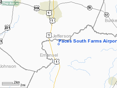
Paces South Farms Airport |
Location
& QuickFacts
|
FAA Information Effective: |
2007-07-05 |
|
Airport
Identifier: |
82GA |
|
Airport
Status: |
Operational |
|
Longitude/Latitude: |
082-23-06.9570W/32-48-31.5650N
-82.385266/32.808768 (Estimated) |
|
Elevation: |
275 ft / 83.82 m (Estimated) |
|
Land: |
12
acres |
|
From
nearest city: |
4 nautical miles SW of Wadley, GA |
|
Location: |
Emanuel County, GA |
|
Magnetic Variation: |
04W (1990) |
Owner
& Manager
|
Ownership: |
Privately owned |
|
Owner: |
Paces South Farms |
|
Address: |
Route 2, Box 63a
Midville, GA 30318 |
|
Manager: |
Keith Claxton |
|
Address: |
22 Lambs Chapel Rd
Midville, GA 30441 |
|
Phone number: |
912-252-1556 |
Airport
Operations and Facilities
|
Airport Use: |
Private |
|
Wind
indicator: |
Yes |
|
Segmented
Circle: |
No |
|
Control
Tower: |
No |
|
Sectional
chart: |
Atlanta |
|
Region: |
ASO - Southern |
|
Boundary
ARTCC: |
ZTL - Atlanta |
|
Tie-in
FSS: |
MCN - Macon |
|
FSS
Toll Free: |
1-800-WX-BRIEF |
|
Runway Information
Runway 02/20
|
Dimension: |
3500 x 50 ft / 1066.8 x 15.2 m |
|
Surface: |
TURF, |
|
|
Runway 02 |
Runway 20 |
|
Traffic
Pattern: |
Left |
Left |
|
Displaced
threshold: |
700.00
ft |
0.00 ft |
|
Obstruction: |
40 ft plines, 60.0 ft from runway |
|
|
Radio Navigation
Aids
|
ID |
Type |
Name |
Ch |
Freq |
Var |
Dist |
|
EEX |
NDB |
Emanuel County |
|
309.00 |
04W |
9.2 nm |
|
LNH |
NDB |
Millen |
|
205.00 |
05W |
21.7 nm |
|
BXG |
NDB |
Burke County |
|
356.00 |
04W |
23.8 nm |
|
MHP |
NDB |
Metter |
|
432.00 |
03W |
30.3 nm |
|
HIT |
NDB |
Kaolin |
|
360.00 |
05W |
30.6 nm |
|
UQN |
NDB |
Onyun |
|
372.00 |
04W |
35.5 nm |
|
DB |
NDB |
Creke |
|
251.00 |
04W |
37.2 nm |
|
JYL |
NDB |
Sylvania |
|
245.00 |
04W |
41.1 nm |
|
BZ |
NDB |
Bullo |
|
407.00 |
05W |
43.5 nm |
|
HQU |
NDB |
Thomson-mcduffie |
|
333.00 |
04W |
43.7 nm |
|
EMR |
NDB |
Emory |
|
385.00 |
04W |
43.9 nm |
|
UMB |
NDB |
Culvr |
|
380.00 |
04W |
44.2 nm |
|
CWV |
NDB |
Claxton |
|
395.50 |
04W |
44.8 nm |
|
AA |
NDB |
Cedar |
|
341.00 |
04W |
45.0 nm |
|
RVJ |
NDB |
Prison |
|
424.00 |
03W |
46.7 nm |
|
MQW |
NDB |
Mc Rae |
|
280.00 |
03W |
49.8 nm |
|
DBN |
VORTAC |
Dublin |
078X |
113.10 |
01W |
27.1 nm |
Remarks
Based
Aircraft
|
Aircraft
based on field: |
1 |
|
Single
Engine Airplanes: |
1 |
Paces South Farms Airport
Address:
Emanuel County, GA
Tel:
912-252-1556
Images
and information placed above are from
http://www.airport-data.com/airport/82GA/
We
thank them for the data!
| General
Info |
| Country |
United
States |
| State |
GEORGIA
|
| FAA ID |
82GA
|
| Latitude |
32-48-31.565N
|
| Longitude |
082-23-06.957W
|
| Elevation |
275 feet
|
| Near City |
WADLEY
|
We don't guarantee the information is fresh and accurate. The data may
be wrong or outdated.
For more up-to-date information please refer to other sources.
|
|


