 |
|
Newnan Coweta County Airport |
Coordinates: 33°18â²42â³N 084°46â²11â³W / 33.31167°N 84.76972°W / 33.31167; -84.76972
| Newnan Coweta County Airport |
 |
| IATA: none â ICAO: KCCO â FAA LID: CCO |
| Summary |
| Airport type |
Public |
| Owner |
Newnan Coweta County Airport Authority |
| Location |
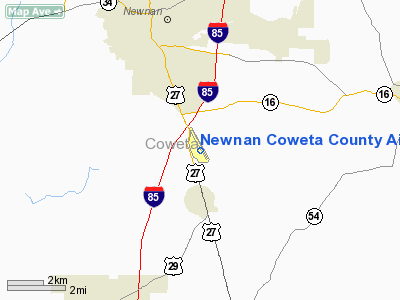
Newnan, Georgia |
| Elevation AMSL |
970 ft / 296 m |
| Runways |
| Direction |
Length |
Surface |
| ft |
m |
| 14/32 |
5,500 |
1,676 |
Asphalt |
| Statistics (2007) |
| Aircraft operations |
30,000 |
| Based aircraft |
156 |
| Source: Federal Aviation Administration |
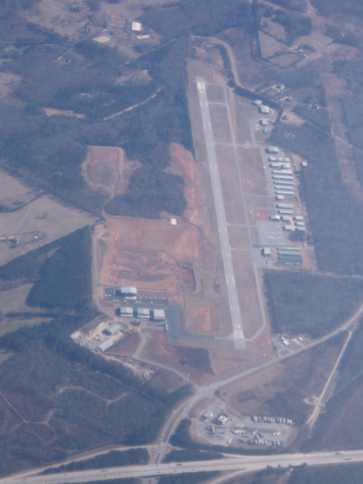
Newnan Coweta County Airport (ICAO: KCCO, FAA LID: CCO) is a public airport in Coweta County, Georgia, United States. Located five miles (8 km) south of the central business district of Newnan, it is surrounded by US 29 and I-85 and 100 acres (0.40 km) owned by the county.
The airport name appears in various formats, depending on the source. The FAA refers to it as Newnan Coweta County Airport, but the Georgia DOT airport directory adds a hyphen for Newnan-Coweta County Airport. The City of Newnan's web site drops "County" from the name, resulting in Newnan-Coweta Airport. Cowenta County's web site drops both "County" and the hyphen, for Newnan Coweta Airport and also has a photo of a sign at the airport bearing that name.
Although most U.S. airports use the same three-letter location identifier for the FAA and IATA, Newnan Coweta County Airport is assigned CCO by the FAA but has no designation from the IATA.
Facilities and aircraft
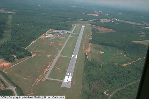
Newnan Coweta County Airport covers an area of 270 acres (109 ha) and contains one asphalt paved runway designated 14/32 and measuring 5,500 x 100 ft (1,676 x 30 m). For the 12-month period ending July 31, 2007, the airport had 30,000 general aviation aircraft operations, an average of 82 per day. There are 156 aircraft based at this airport: 95% single-engine, 3% jet (5) and 2% helicopter.
The above content comes from Wikipedia and is published under free licenses – click here to read more.
|
 |
(Click on the photo to enlarge) |
Location
& QuickFacts
|
FAA Information Effective: |
2007-07-05 |
|
Airport
Identifier: |
CCO |
|
Airport
Status: |
Operational |
|
Longitude/Latitude: |
084-46-11.1150W/33-18-41.6300N
-84.769754/33.311564 (Estimated) |
|
Elevation: |
970 ft / 295.66 m (Surveyed) |
|
Land: |
252 acres |
|
From
nearest city: |
4 nautical miles S of Atlanta, GA |
|
Location: |
Coweta County, GA |
|
Magnetic Variation: |
03W (2000) |
Owner
& Manager
|
Ownership: |
Publicly owned |
|
Owner: |
Newnan & Coweta Co Arpt Auth |
|
Address: |
115 Airport Road, Box 2
Newnan, GA 30263 |
|
Phone
number: |
770-254-8102 |
|
Manager: |
Calvin Walker |
|
Address: |
115 Airport Road, Box 2
Newnan, GA 30263 |
|
Phone number: |
770-254-8102 |
Airport
Operations and Facilities
|
Airport Use: |
Open to public |
|
Wind
indicator: |
Yes |
|
Segmented
Circle: |
Yes |
|
Control
Tower: |
No |
|
Lighting
Schedule: |
DUSK-DAWN
ACTVT MIRL RY 14/32 & PAPI RYS 14 & 32 AND MALSR
RY 32 - CTAF. |
|
Beacon
Color: |
Clear-Green (lighted land airport) |
|
Landing
fee charge: |
No |
|
Sectional
chart: |
Atlanta |
|
Region: |
ASO - Southern |
|
Boundary
ARTCC: |
ZTL - Atlanta |
|
Tie-in
FSS: |
MCN - Macon |
|
FSS
on Airport: |
No |
|
FSS
Toll Free: |
1-800-WX-BRIEF |
|
NOTAMs
Facility: |
CCO (NOTAM-d service avaliable) |
|
Federal Agreements: |
NGY |
Airport
Communications
|
CTAF: |
122.800 |
|
Unicom: |
122.800 |
Airport
Services
|
Fuel available: |
100LLA1 |
|
Airframe Repair: |
MAJOR |
|
Power Plant Repair: |
MAJOR |
|
Bottled
Oxygen: |
NONE |
|
Bulk
Oxygen: |
NONE |
|
Runway Information
Runway 14/32
|
Dimension: |
5500 x 100 ft / 1676.4 x 30.5 m |
|
Surface: |
ASPH, Good Condition |
|
Weight
Limit: |
Single wheel: 26000 lbs.
Dual wheel: 37000 lbs. |
|
Edge
Lights: |
Medium |
|
|
Runway 14 |
Runway 32 |
|
Longitude: |
084-46-32.1400W |
084-45-50.0900W |
|
Latitude: |
33-19-02.3000N |
33-18-20.9600N |
|
Elevation: |
970.00
ft |
934.00
ft |
|
Alignment: |
127 |
127 |
|
ILS
Type: |
|
LOCALIZER |
|
Traffic
Pattern: |
Left |
Left |
|
Markings: |
Non-precision instrument, Good Condition |
Non-precision instrument, Good Condition |
|
Crossing
Height: |
31.00
ft |
33.00
ft |
|
VASI: |
2-light PAPI on left side |
2-light PAPI on left side |
|
Visual
Glide Angle: |
3.00° |
3.00° |
|
Approach
lights: |
|
MALSR |
|
Obstruction: |
68 ft trees, 1560.0 ft from runway, 410 ft
right of centerline, 20:1 slope to clear |
24 ft trees, 682.0 ft from runway, 310 ft right
of centerline, 20:1 slope to clear |
|
Radio Navigation
Aids
|
ID |
Type |
Name |
Ch |
Freq |
Var |
Dist |
|
EQQ |
NDB |
Coweta County |
|
234.00 |
03W |
4.4 nm |
|
FF |
NDB |
Pecat |
|
316.00 |
02W |
14.2 nm |
|
GPQ |
NDB |
Carrollton |
|
278.00 |
02W |
23.7 nm |
|
FT |
NDB |
Flanc |
|
344.00 |
02W |
27.9 nm |
|
JHH |
NDB |
Griffin |
|
412.00 |
04W |
28.3 nm |
|
PIM |
NDB |
Pine Mountain |
|
272.00 |
03W |
28.6 nm |
|
BR |
NDB |
Redan |
|
266.00 |
02W |
30.5 nm |
|
OP |
NDB |
Yates |
|
339.00 |
03W |
37.6 nm |
|
DOB |
TACAN |
Dobbins |
077X |
|
01W |
38.6 nm |
|
PDK |
VOR/DME |
Peachtree |
113X |
116.60 |
02W |
41.3 nm |
|
ATL |
VORTAC |
Atlanta |
116X |
116.90 |
00W |
25.4 nm |
|
LGC |
VORTAC |
Lagrange |
103X |
115.60 |
01E |
27.0 nm |
|
CSG |
VORTAC |
Columbus |
118X |
117.10 |
01E |
43.7 nm |
|
ATL |
VOT |
Atlanta Muni |
|
111.00 |
|
27.0 nm |
Remarks
- GCO
AVBL ON FREQ 121.725 THRU FLT SVCS.
Based
Aircraft
|
Aircraft
based on field: |
88 |
|
Single
Engine Airplanes: |
67 |
|
Multi
Engine Airplanes: |
12 |
|
Jet Engine
Airplanes: |
6 |
|
Helicopters: |
3 |
Operational Statistics
Time Period: 2004-06-11
- 2005-06-10
|
Aircraft
Operations: |
83/Day |
|
General
Aviation Local: |
53.0% |
|
General
Aviation Itinerant: |
46.4% |
|
Military: |
0.7% |
Newnan Coweta County Airport
Address:
Coweta County, GA
Tel:
770-254-8102
Images
and information placed above are from
http://www.airport-data.com/airport/CCO/
We
thank them for the data!
| General
Info |
| Country |
United
States |
| State |
GEORGIA
|
| FAA ID |
CCO
|
| Latitude |
33-18-43.500N
|
| Longitude |
084-46-13.000W
|
| Elevation |
970 feet
|
| Near City |
NEWNAN
|
We don't guarantee the information is fresh and accurate. The data may
be wrong or outdated.
For more up-to-date information please refer to other sources.
|
|


