 |
|
|
|
|
|
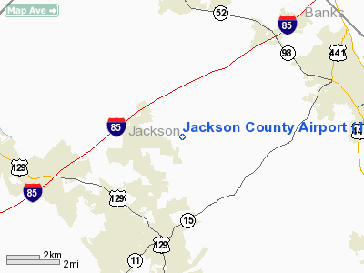
Location
& QuickFacts
|
FAA Information Effective: |
2007-07-05 |
|
Airport
Identifier: |
19A |
|
Airport
Status: |
Operational |
|
Longitude/Latitude: |
083-33-39.8770W/34-10-27.8945N
-83.561077/34.174415 (Estimated) |
|
Elevation: |
951 ft / 289.86 m (Surveyed) |
|
Land: |
181 acres |
|
From
nearest city: |
3 nautical miles NE of Jefferson, GA |
|
Location: |
Jackson County, GA |
|
Magnetic Variation: |
03W (1990) |
Owner
& Manager
|
Ownership: |
Publicly owned |
|
Owner: |
Jackson County, C/o Crandell Jones |
|
Address: |
67 Athens Street
Jefferson, GA 30549 |
|
Phone
number: |
706-367-6314 |
|
Manager: |
Robert Banks |
|
Address: |
485 Lyle Field Road
Jefferson, GA 30549 |
|
Phone number: |
706-367-1493 |
Airport
Operations and Facilities
|
Airport Use: |
Open to public |
|
Wind
indicator: |
Yes |
|
Segmented
Circle: |
Yes |
|
Control
Tower: |
No |
|
Lighting
Schedule: |
DUSK-DAWN
MIRL RY 16/34 PRESET ON LOW INTST DUSK-2200; TO INCR INTST
& ACTVT AFTER 2200 - CTAF. |
|
Beacon
Color: |
Clear-Green (lighted land airport) |
|
Landing
fee charge: |
No |
|
Sectional
chart: |
Atlanta |
|
Region: |
ASO - Southern |
|
Boundary
ARTCC: |
ZTL - Atlanta |
|
Tie-in
FSS: |
MCN - Macon |
|
FSS
on Airport: |
No |
|
FSS
Toll Free: |
1-800-WX-BRIEF |
|
NOTAMs
Facility: |
MCN (NOTAM-d service avaliable) |
|
Federal Agreements: |
NGY |
Airport
Communications
|
CTAF: |
122.800 |
|
Unicom: |
122.800 |
Airport
Services
|
Fuel available: |
100LLA |
|
Airframe Repair: |
MINOR |
|
Power Plant Repair: |
MINOR |
|
Bottled
Oxygen: |
NONE |
|
Bulk
Oxygen: |
NONE |
|
Runway Information
Runway 16/34
|
Dimension: |
4109 x 75 ft / 1252.4 x 22.9 m |
|
Surface: |
ASPH, Good Condition |
|
Weight
Limit: |
Single wheel: 30000 lbs.
Dual wheel: 43000 lbs. |
|
Edge
Lights: |
Medium |
|
|
Runway 16 |
Runway 34 |
|
Longitude: |
083-33-46.8670W |
083-33-32.8870W |
|
Latitude: |
34-10-47.3710N |
34-10-08.4180N |
|
Elevation: |
939.00
ft |
951.00
ft |
|
Alignment: |
127 |
127 |
|
Traffic
Pattern: |
Left |
Left |
|
Markings: |
Non-precision instrument, Fair Condition |
Non-precision instrument, Fair Condition |
|
VASI: |
2-light PAPI on left side |
2-light PAPI on left side |
|
Obstruction: |
41 ft trees, 205.0 ft from runway, 260 ft left
of centerline
TEMP DIRT BANK 230 FT LEFT OF THLD, EXTENDING FM THLD TO 300
FT NW. |
50 ft trees, 200.0 ft from runway, 245 ft right
of centerline
POWER POLE 195 FT FM THLD, 210 FT RIGHT. |
|
Radio Navigation
Aids
|
ID |
Type |
Name |
Ch |
Freq |
Var |
Dist |
|
DDA |
NDB |
Commerce |
|
244.00 |
03W |
7.0 nm |
|
BMW |
NDB |
Barrow County |
|
404.00 |
03W |
14.4 nm |
|
FKV |
NDB |
Flowery Branch |
|
365.00 |
03W |
17.3 nm |
|
AJR |
NDB |
Habersham |
|
347.00 |
03W |
19.7 nm |
|
BJT |
NDB |
Bulldog |
|
221.00 |
03W |
21.6 nm |
|
JNM |
NDB |
Monroe |
|
392.00 |
03W |
27.5 nm |
|
VOF |
NDB |
Alcovy |
|
370.00 |
03W |
34.5 nm |
|
VV |
NDB |
Junne |
|
353.00 |
05W |
41.6 nm |
|
IIY |
NDB |
Washington/wilkes County |
|
435.00 |
03W |
44.3 nm |
|
CEU |
NDB |
Clemson |
|
257.00 |
05W |
44.9 nm |
|
DJD |
NDB |
Canton |
|
415.00 |
04W |
46.3 nm |
|
AND |
NDB |
Anderson County |
|
230.00 |
04W |
46.6 nm |
|
JZP |
NDB |
Pickens County |
|
285.00 |
04W |
47.7 nm |
|
BR |
NDB |
Redan |
|
266.00 |
02W |
49.1 nm |
|
DOB |
TACAN |
Dobbins |
077X |
|
01W |
49.6 nm |
|
PDK |
VOR/DME |
Peachtree |
113X |
116.60 |
02W |
40.9 nm |
|
AHN |
VORTAC |
Athens |
33 |
109.60 |
00E |
18.0 nm |
|
ODF |
VORTAC |
Foothills |
081X |
113.40 |
00E |
34.0 nm |
|
ELW |
VORTAC |
Electric City |
023X |
108.60 |
00E |
41.3 nm |
|
HRS |
VORTAC |
Harris |
035X |
109.80 |
00E |
49.4 nm |
Remarks
- DEER
ON & INVOF ARPT.
- PAEW
INVOF RY 16/34.
Based
Aircraft
|
Aircraft
based on field: |
74 |
|
Single
Engine Airplanes: |
67 |
|
Helicopters: |
1 |
|
Ultralights: |
6 |
Operational Statistics
Time Period: 2005-07-20
- 2006-07-19
|
Aircraft
Operations: |
184/Week |
|
General
Aviation Local: |
62.8% |
|
General
Aviation Itinerant: |
36.6% |
|
Military: |
0.5% |
Jackson County Airport
Address:
Jackson County, GA
Tel:
706-367-6314,
706-367-1493
Images
and information placed above are from
http://www.airport-data.com/airport/19A/
We
thank them for the data!
| General
Info |
| Country |
United
States |
| State |
GEORGIA
|
| FAA ID |
19A
|
| Latitude |
34-10-26.489N
|
| Longitude |
083-33-38.395W
|
| Elevation |
951 feet
|
| Near City |
JEFFERSON
|
We don't guarantee the information is fresh and accurate. The data may
be wrong or outdated.
For more up-to-date information please refer to other sources.
|
|


