 |
|
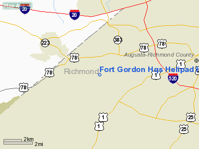
Fort Gordon Hqs Helipad Heliport |
Location
& QuickFacts
|
FAA Information Effective: |
2007-01-18 |
|
Airport
Identifier: |
GA26 |
|
Airport
Status: |
Operational |
|
Longitude/Latitude: |
082-08-22.4300W/33-25-13.4990N
-82.139564/33.420416 (Estimated) |
|
Elevation: |
458 ft / 139.60 m (Estimated) |
|
Land: |
0
acres |
|
From
nearest city: |
7 nautical miles SW of Fort Gordon(augusta),
GA |
|
Location: |
Richmond County, GA |
|
Magnetic Variation: |
04W (1985) |
Owner
& Manager
|
Ownership: |
Army owned |
|
Owner: |
U S Army Atca-aso |
|
Address: |
Cameron Stn
Alexandria, VA 22314 |
|
Manager: |
Tim Weegar |
|
Address: |
1501 Aviation Way
Augusta, GA 30906 |
|
Phone number: |
404-798-8277 |
Airport
Operations and Facilities
|
Airport Use: |
Private |
|
Wind
indicator: |
Yes |
|
Segmented
Circle: |
No |
|
Control
Tower: |
No |
|
Landing
fee charge: |
No |
|
Sectional
chart: |
Atlanta |
|
Region: |
ASO - Southern |
|
Boundary
ARTCC: |
ZTL - Atlanta |
|
Tie-in
FSS: |
MCN - Macon |
|
FSS
on Airport: |
No |
|
FSS
Phone: |
478-784-1155 |
|
FSS
Toll Free: |
1-800-WX-BRIEF |
|
Runway Information
Helipad H1
|
Dimension: |
40 x 40 ft / 12.2 x 12.2 m |
|
Surface: |
CONC, |
|
|
Runway H1 |
Runway |
|
Traffic
Pattern: |
Left |
Left |
|
Radio Navigation
Aids
|
ID |
Type |
Name |
Ch |
Freq |
Var |
Dist |
|
EMR |
NDB |
Emory |
|
385.00 |
04W |
7.6 nm |
|
HQU |
NDB |
Thomson-mcduffie |
|
333.00 |
04W |
19.9 nm |
|
BXG |
NDB |
Burke County |
|
356.00 |
04W |
23.7 nm |
|
AA |
NDB |
Cedar |
|
341.00 |
04W |
24.8 nm |
|
AIK |
NDB |
Aiken |
|
347.00 |
04W |
27.0 nm |
|
LNH |
NDB |
Millen |
|
205.00 |
05W |
32.8 nm |
|
BKO |
NDB |
Barnwell |
|
392.00 |
06W |
36.2 nm |
|
IIY |
NDB |
Washington/wilkes County |
|
435.00 |
03W |
39.9 nm |
|
VV |
NDB |
Junne |
|
353.00 |
05W |
46.2 nm |
|
HIT |
NDB |
Kaolin |
|
360.00 |
05W |
47.0 nm |
|
EEX |
NDB |
Emanuel County |
|
309.00 |
04W |
48.0 nm |
|
ALD |
VOR |
Allendale |
|
116.70 |
01W |
49.2 nm |
|
IRQ |
VORTAC |
Colliers |
086X |
113.90 |
04W |
17.3 nm |
|
GRD |
VORTAC |
Greenwood |
102X |
115.50 |
01W |
50.0 nm |
Remarks
- DO
NOT OVERFLY HOSP OR POST HQ.
- REFUEL
BUSH FLD 9NM ESE.
- PILOTS
CTC RANGE CTL FOR BRIEFING PRIOR TO FLT IN R-3004. V780-5005/3342.
- VFR
WX CONDS, PVT USE.
Based
Aircraft
|
Aircraft
based on field: |
1 |
|
Helicopters: |
1 |
Fort Gordon Hqs Helipad Heliport
Address:
Richmond County, GA
Tel:
404-798-8277
Images
and information placed above are from
http://www.airport-data.com/airport/GA26/
We
thank them for the data!
| General
Info |
| Country |
United
States |
| State |
GEORGIA
|
| FAA ID |
GA26
|
| Latitude |
33-25-13.499N
|
| Longitude |
082-08-22.430W
|
| Elevation |
458 feet
|
| Near City |
FORT GORDON(AUGUSTA)
|
We don't guarantee the information is fresh and accurate. The data may
be wrong or outdated.
For more up-to-date information please refer to other sources.
|
|


