 |
|
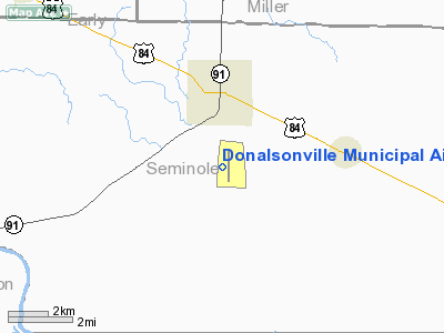
Donalsonville Municipal Airport |
|
|
Location
& QuickFacts
|
FAA Information Effective: |
2007-01-18 |
|
Airport
Identifier: |
17J |
|
Airport
Status: |
Operational |
|
Longitude/Latitude: |
084-52-39.4000W/31-00-25.0000N
-84.877611/31.006944 (Estimated) |
|
Elevation: |
147 ft / 44.81 m (Estimated) |
|
Land: |
715 acres |
|
From
nearest city: |
1 nautical miles S of Donalsonville, GA |
|
Location: |
Seminole County, GA |
|
Magnetic Variation: |
03W (2000) |
Owner
& Manager
|
Ownership: |
Publicly owned |
|
Owner: |
City Of Donalsonville
AND SEMINOLE COUNTY. |
|
Address: |
Po Box 308
Donalsville, GA 39845 |
|
Phone
number: |
229-524-2118 |
|
Manager: |
Marty Shingler |
|
Address: |
P.o. Box 308
Donalsonville, GA 39845 |
|
Phone number: |
229-524-2118 |
Airport
Operations and Facilities
|
Airport Use: |
Open to public |
|
Wind
indicator: |
Yes |
|
Segmented
Circle: |
Yes |
|
Control
Tower: |
No |
|
Lighting
Schedule: |
DUSK-DAWN |
|
Beacon
Color: |
Clear-Green (lighted land airport) |
|
Landing
fee charge: |
No |
|
Sectional
chart: |
Jacksonville |
|
Region: |
ASO - Southern |
|
Boundary
ARTCC: |
ZJX - Jacksonville |
|
Tie-in
FSS: |
MCN - Macon |
|
FSS
on Airport: |
No |
|
FSS
Phone: |
478-784-1155 |
|
FSS
Toll Free: |
1-800-WX-BRIEF |
|
NOTAMs
Facility: |
MCN (NOTAM-d service avaliable) |
|
Federal Agreements: |
NR |
Airport
Communications
Airport
Services
|
Fuel available: |
100LL |
|
Bottled
Oxygen: |
NONE |
|
Bulk
Oxygen: |
NONE |
|
Runway Information
Runway 18/36
|
Dimension: |
5186 x 100 ft / 1580.7 x 30.5 m |
|
Surface: |
ASPH, Good Condition |
|
Weight
Limit: |
Single wheel: 20000 lbs. |
|
Edge
Lights: |
Medium |
|
|
Runway 18 |
Runway 36 |
|
Longitude: |
084-52-38.1315W |
084-52-40.6961W |
|
Latitude: |
31-00-50.6160N |
30-59-59.3418N |
|
Elevation: |
147.00
ft |
130.00
ft |
|
Alignment: |
127 |
2 |
|
Traffic
Pattern: |
Left |
Left |
|
Markings: |
Non-precision instrument, Good Condition
RY 18/36 MARKINGS FADED. |
Non-precision instrument, Good Condition |
|
Obstruction: |
, 50:1 slope to clear |
64 ft brush, 2312.0 ft from runway, 400 ft
left of centerline, 33:1 slope to clear |
|
Radio Navigation
Aids
|
ID |
Type |
Name |
Ch |
Freq |
Var |
Dist |
|
LYZ |
NDB |
Willis |
|
359.00 |
01W |
18.2 nm |
|
SMY |
NDB |
Soyya |
|
329.00 |
02W |
19.7 nm |
|
IWJ |
NDB |
Blaak |
|
344.00 |
03W |
27.1 nm |
|
CXU |
NDB |
Camilla |
|
369.00 |
02W |
35.3 nm |
|
CYR |
NDB |
Caidy |
|
338.00 |
01W |
37.7 nm |
|
BKK |
NDB |
Tri County |
|
275.00 |
02W |
38.5 nm |
|
AB |
NDB |
Putny |
|
227.00 |
02W |
41.0 nm |
|
HYE |
NDB |
Hanchey |
|
221.00 |
00E |
45.2 nm |
|
TL |
NDB |
Wakul |
|
379.00 |
01W |
48.9 nm |
|
LOR |
NDB |
Lowe |
|
269.00 |
03W |
49.3 nm |
|
FYL |
VOR |
Tri County |
|
108.40 |
08W |
39.0 nm |
|
HEY |
VOR |
Hanchey |
|
110.60 |
02E |
45.6 nm |
|
OZR |
VOR/DME |
Cairns |
049X |
111.20 |
02E |
46.4 nm |
|
MAI |
VORTAC |
Marianna |
087X |
114.00 |
00E |
18.4 nm |
|
RRS |
VORTAC |
Wiregrass |
053X |
111.60 |
02E |
33.0 nm |
|
SZW |
VORTAC |
Seminole |
122X |
117.50 |
02E |
37.6 nm |
|
PZD |
VORTAC |
Pecan |
108X |
116.10 |
02W |
49.2 nm |
|
TLH |
VOT |
Tallahassee Muni |
|
111.00 |
|
45.4 nm |
Remarks
Based
Aircraft
|
Aircraft
based on field: |
13 |
|
Single
Engine Airplanes: |
9 |
|
Ultralights: |
4 |
Operational Statistics
Time Period: 2005-04-07
- 2006-04-06
|
Aircraft
Operations: |
193/Week |
|
General
Aviation Local: |
40.0% |
|
General
Aviation Itinerant: |
30.0% |
|
Military: |
30.0% |
Donalsonville Municipal Airport
Address:
Seminole County, GA
Tel:
229-524-2118
Images
and information placed above are from
http://www.airport-data.com/airport/17J/
We
thank them for the data!
| General
Info |
| Country |
United
States |
| State |
GEORGIA
|
| FAA ID |
17J
|
| Latitude |
31-00-25.000N
|
| Longitude |
084-52-39.400W
|
| Elevation |
147 feet
|
| Near City |
DONALSONVILLE
|
We don't guarantee the information is fresh and accurate. The data may
be wrong or outdated.
For more up-to-date information please refer to other sources.
|
|


