 |
|
|
|
|
|
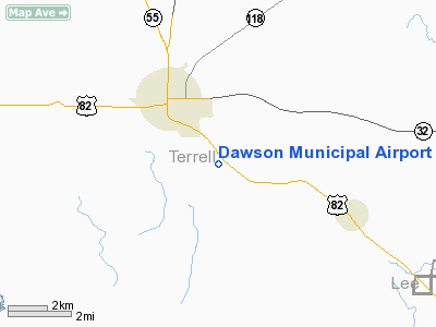
Location
& QuickFacts
|
FAA Information Effective: |
2007-01-18 |
|
Airport
Identifier: |
16J |
|
Airport
Status: |
Operational |
|
Longitude/Latitude: |
084-25-09.4260W/31-44-35.8250N
-84.419285/31.743285 (Estimated) |
|
Elevation: |
333 ft / 101.50 m (Surveyed) |
|
Land: |
149 acres |
|
From
nearest city: |
2 nautical miles SE of Dawson, GA |
|
Location: |
Terrell County, GA |
|
Magnetic Variation: |
02W (1995) |
Owner
& Manager
|
Ownership: |
Publicly owned |
|
Owner: |
Terrell County Airport Authority |
|
Address: |
177 South Main Street
Dawson, GA 39842 |
|
Phone number: |
229-995-5657 |
|
Manager: |
W.d. Garner |
|
Address: |
2678 Albany Hwy
Dawson, GA 39842 |
|
Phone number: |
229-995-3787 |
Airport
Operations and Facilities
|
Airport Use: |
Open to public |
|
Wind
indicator: |
Yes |
|
Segmented
Circle: |
Yes |
|
Control
Tower: |
No |
|
Lighting
Schedule: |
DUSK-DAWN
MIRL RY 13/31 PRESET MED INTST DUSK-2200, AFT 2200 ACTVT
- CTAF.
ACTVT PAPI RYS 13 AND 31 - CTAF. |
|
Beacon
Color: |
Clear-Green (lighted land airport) |
|
Landing
fee charge: |
No |
|
Sectional
chart: |
Jacksonville |
|
Region: |
ASO - Southern |
|
Boundary
ARTCC: |
ZJX - Jacksonville |
|
Tie-in
FSS: |
MCN - Macon |
|
FSS
on Airport: |
No |
|
FSS
Phone: |
478-784-1155 |
|
FSS
Toll Free: |
1-800-WX-BRIEF |
|
NOTAMs
Facility: |
MCN (NOTAM-d service avaliable) |
|
Federal Agreements: |
NY1 |
Airport
Communications
|
CTAF: |
122.800 |
|
Unicom: |
122.800 |
Airport
Services
|
Fuel available: |
100LL |
|
Airframe Repair: |
MINOR |
|
Power Plant Repair: |
MAJOR |
|
Bottled
Oxygen: |
NONE |
|
Bulk
Oxygen: |
NONE |
|
Runway Information
Runway 13/31
|
Dimension: |
4510 x 75 ft / 1374.6 x 22.9 m |
|
Surface: |
ASPH, Good Condition |
|
Weight
Limit: |
Single wheel: 16000 lbs. |
|
Edge
Lights: |
Medium |
|
|
Runway 13 |
Runway 31 |
|
Longitude: |
084-25-28.8410W |
084-24-50.0100W |
|
Latitude: |
31-44-50.6730N |
31-44-20.9760N |
|
Elevation: |
333.00
ft |
289.00
ft |
|
Traffic
Pattern: |
Left |
Left |
|
Markings: |
Non-precision instrument, Poor Condition
RUNWAY MARKINGS BADLY FADED. |
Non-precision instrument, Poor Condition
RUNWAY MARKINGS BADLY FADED. |
|
Crossing
Height: |
28.00
ft |
22.00 ft |
|
VASI: |
2-light PAPI on left side |
2-light PAPI on left side |
|
Visual
Glide Angle: |
3.00° |
3.00° |
|
Obstruction: |
, 50:1 slope to clear |
18 ft road, 290.0 ft from runway, 140 ft left
of centerline, 5:1 slope to clear
RY 31 12 TO 25 FT BRUSH 117 FT RIGHT, 10 FT ROAD & 12
TO 25 FT BRUSH 75 FT LEFT, AT THLD. |
|
Radio Navigation
Aids
|
ID |
Type |
Name |
Ch |
Freq |
Var |
Dist |
|
AB |
NDB |
Putny |
|
227.00 |
02W |
18.8 nm |
|
IWJ |
NDB |
Blaak |
|
344.00 |
03W |
26.8 nm |
|
LKG |
NDB |
Lindbergh |
|
242.00 |
03W |
30.4 nm |
|
OHY |
NDB |
Coney |
|
400.00 |
02W |
32.3 nm |
|
CXU |
NDB |
Camilla |
|
369.00 |
02W |
33.1 nm |
|
IZS |
NDB |
Montezuma |
|
426.00 |
04W |
43.0 nm |
|
AWS |
NDB |
Lawson |
|
335.00 |
02W |
45.2 nm |
|
LYZ |
NDB |
Willis |
|
359.00 |
01W |
46.6 nm |
|
LSF |
VOR/DME |
Lawson |
051X |
111.40 |
02W |
45.9 nm |
|
PZD |
VORTAC |
Pecan |
108X |
116.10 |
02W |
8.3 nm |
|
EUF |
VORTAC |
Eufaula |
029X |
109.20 |
02E |
38.4 nm |
Remarks
- DEER
ON & INVOF ARPT.
- VFR
OPNS ONLY
Based
Aircraft
|
Aircraft
based on field: |
66 |
|
Single
Engine Airplanes: |
64 |
|
Multi
Engine Airplanes: |
2 |
Operational Statistics
Time Period: 2005-06-08
- 2006-06-07
|
Aircraft
Operations: |
132/Week |
|
General
Aviation Local: |
49.6% |
|
General
Aviation Itinerant: |
49.6% |
|
Military: |
0.7% |
Dawson Municipal Airport
Address:
Terrell County, GA
Tel:
229-995-5657, 229-995-3787
Images
and information placed above are from
http://www.airport-data.com/airport/16J/
We
thank them for the data!
| General
Info |
| Country |
United
States |
| State |
GEORGIA
|
| FAA ID |
16J
|
| Latitude |
31-44-35.825N
|
| Longitude |
084-25-09.426W
|
| Elevation |
333 feet
|
| Near City |
DAWSON
|
We don't guarantee the information is fresh and accurate. The data may
be wrong or outdated.
For more up-to-date information please refer to other sources.
|
|


