 |
|
Location
& QuickFacts
|
FAA Information Effective: |
2007-01-18 |
|
Airport
Identifier: |
98GA |
|
Airport
Status: |
Operational |
|
Longitude/Latitude: |
083-54-44.6650W/33-12-20.4480N
-83.912407/33.205680 (Estimated) |
|
Elevation: |
545 ft / 166.12 m (Estimated) |
|
Land: |
250 acres |
|
From
nearest city: |
2 nautical miles S of Indian Springs, GA |
|
Location: |
Butts County, GA |
|
Magnetic Variation: |
03W (1990) |
Owner
& Manager
|
Ownership: |
Privately owned |
|
Owner: |
W. H. Torbett |
|
Address: |
Rt 4, Box 566
Forsyth, GA 31029 |
|
Phone number: |
404-522-8517 |
|
Manager: |
W. H. Torbett |
|
Address: |
Rt 4, Box 566
Forsyth, GA 31029 |
|
Phone number: |
404-522-8517 |
Airport
Operations and Facilities
|
Airport Use: |
Private |
|
Wind
indicator: |
Yes |
|
Segmented
Circle: |
No |
|
Control
Tower: |
No |
|
Sectional
chart: |
Atlanta |
|
Region: |
ASO - Southern |
|
Boundary
ARTCC: |
ZTL - Atlanta |
|
Tie-in
FSS: |
MCN - Macon |
|
FSS
on Airport: |
No |
|
FSS
Phone: |
478-784-1155 |
|
FSS
Toll Free: |
1-800-WX-BRIEF |
|
Runway Information
Runway 13/31
|
Dimension: |
1300 x 30 ft / 396.2 x 9.1 m |
|
Surface: |
TURF, |
|
|
Runway 13 |
Runway 31 |
|
Traffic
Pattern: |
Left |
Right |
|
Obstruction: |
|
30 ft trees, 200.0 ft from runway |
|
Radio Navigation
Aids
|
ID |
Type |
Name |
Ch |
Freq |
Var |
Dist |
|
JHH |
NDB |
Griffin |
|
412.00 |
04W |
15.9 nm |
|
OP |
NDB |
Yates |
|
339.00 |
03W |
22.1 nm |
|
VOF |
NDB |
Alcovy |
|
370.00 |
03W |
26.3 nm |
|
FF |
NDB |
Pecat |
|
316.00 |
02W |
29.4 nm |
|
BR |
NDB |
Redan |
|
266.00 |
02W |
33.1 nm |
|
JNM |
NDB |
Monroe |
|
392.00 |
03W |
33.3 nm |
|
UMB |
NDB |
Culvr |
|
380.00 |
04W |
38.0 nm |
|
EQQ |
NDB |
Coweta County |
|
234.00 |
03W |
40.4 nm |
|
BEP |
NDB |
Bay Creek |
|
350.00 |
03W |
45.6 nm |
|
BMW |
NDB |
Barrow County |
|
404.00 |
03W |
46.7 nm |
|
FT |
NDB |
Flanc |
|
344.00 |
02W |
49.5 nm |
|
PDK |
VOR/DME |
Peachtree |
113X |
116.60 |
02W |
44.7 nm |
|
MCN |
VORTAC |
Macon |
089X |
114.20 |
01E |
33.7 nm |
|
ATL |
VORTAC |
Atlanta |
116X |
116.90 |
00W |
36.5 nm |
|
ATL |
VOT |
Atlanta Muni |
|
111.00 |
|
37.4 nm |
Remarks
- PROVIDED
VFR/PR USE; ALL OPS NE OF RY.
Based
Aircraft
|
Aircraft
based on field: |
1 |
|
Single
Engine Airplanes: |
1 |
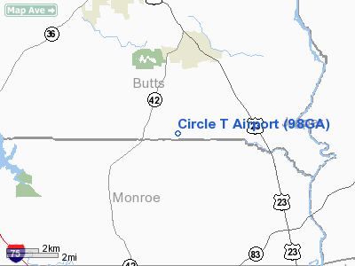
Circle Torbett Airport
Address:
Butts County, GA
Tel:
404-522-8517
Images
and information placed above are from
http://www.airport-data.com/airport/98GA/
We
thank them for the data!
| General
Info |
| Country |
United
States |
| State |
GEORGIA
|
| FAA ID |
98GA
|
| Latitude |
33-12-20.448N
|
| Longitude |
083-54-44.665W
|
| Elevation |
545 feet
|
| Near City |
INDIAN
SPRINGS |
We don't guarantee the information is fresh and accurate. The data may
be wrong or outdated.
For more up-to-date information please refer to other sources.
|
|


