|
|
|
 |
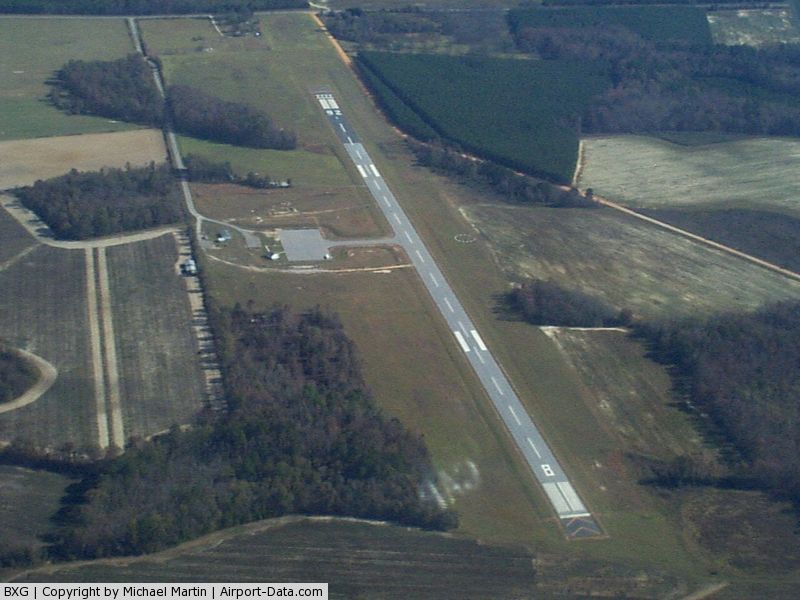
(Click on the photo to enlarge) |
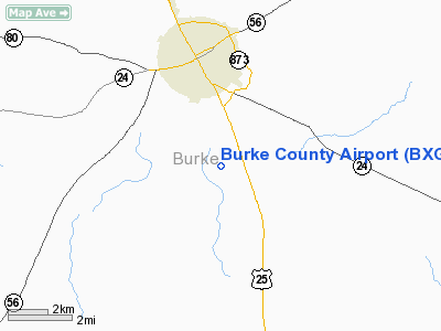
Location
& QuickFacts
|
FAA Information Effective: |
2007-01-18 |
|
Airport
Identifier: |
BXG |
|
Airport
Status: |
Operational |
|
Longitude/Latitude: |
082-00-09.6850W/33-02-28.6400N
-82.002690/33.041289 (Estimated) |
|
Elevation: |
302 ft / 92.05 m (Surveyed) |
|
Land: |
114 acres |
|
From
nearest city: |
3 nautical miles S of Waynesboro, GA |
|
Location: |
Burke County, GA |
|
Magnetic Variation: |
04W (1985) |
Owner
& Manager
|
Ownership: |
Publicly owned |
|
Owner: |
Burke County |
|
Address: |
County Courthouse Po Box 89
Waynesboro, GA 30830 |
|
Phone number: |
706-554-2324 |
|
Manager: |
Merv Waldrop
COUNTY ADMINISTRATOR. |
|
Address: |
Po Box 89
Waynesboro, GA 30830 |
|
Phone number: |
706-554-2324
ARPT PHONE 706-554-5270. |
Airport
Operations and Facilities
|
Airport Use: |
Open to public |
|
Wind
indicator: |
Yes |
|
Segmented
Circle: |
Yes |
|
Control
Tower: |
No |
|
Lighting
Schedule: |
DUSK-DAWN
ACTVT MIRL RY 08/26 - CTAF. |
|
Beacon
Color: |
Clear-Green (lighted land airport) |
|
Landing
fee charge: |
No |
|
Sectional
chart: |
Atlanta |
|
Region: |
ASO - Southern |
|
Boundary
ARTCC: |
ZTL - Atlanta |
|
Tie-in
FSS: |
MCN - Macon |
|
FSS
on Airport: |
No |
|
FSS
Phone: |
478-784-1155 |
|
FSS
Toll Free: |
1-800-WX-BRIEF |
|
NOTAMs
Facility: |
MCN (NOTAM-d service avaliable) |
|
Federal Agreements: |
NY1 |
Airport
Communications
Airport
Services
|
Airframe Repair: |
NONE |
|
Power Plant Repair: |
NONE |
|
Bottled
Oxygen: |
NONE |
|
Bulk
Oxygen: |
NONE |
|
Runway Information
Runway 08/26
|
Dimension: |
4035 x 75 ft / 1229.9 x 22.9 m |
|
Surface: |
ASPH, Good Condition |
|
Weight
Limit: |
Single wheel: 20000 lbs. |
|
Edge
Lights: |
Medium |
|
|
Runway 08 |
Runway 26 |
|
Longitude: |
082-00-32.1100W |
081-59-47.2600W |
|
Latitude: |
33-02-22.1700N |
33-02-35.1100N |
|
Elevation: |
292.00 ft |
302.00 ft |
|
Alignment: |
71 |
127 |
|
Traffic
Pattern: |
Left |
Left |
|
Markings: |
Non-precision instrument, Good Condition |
Non-precision instrument, Good Condition |
|
Displaced
threshold: |
0.00 ft |
90.00 ft |
|
Obstruction: |
49 ft trees, 690.0 ft from runway, 250 ft left
of centerline, 10:1 slope to clear |
69 ft road, 1580.0 ft from runway, 20:1 slope
to clear
RY 26 APCH RATIO 25:1 TO DSPLCD THLD. 63 FT TREES 1575 FT
FROM THLD & 250 FT RIGHT. |
|
Radio Navigation
Aids
|
ID |
Type |
Name |
Ch |
Freq |
Var |
Dist |
|
BXG |
NDB |
Burke County |
|
356.00 |
04W |
0.1 nm |
|
LNH |
NDB |
Millen |
|
205.00 |
05W |
9.0 nm |
|
EMR |
NDB |
Emory |
|
385.00 |
04W |
25.3 nm |
|
JYL |
NDB |
Sylvania |
|
245.00 |
04W |
31.3 nm |
|
EEX |
NDB |
Emanuel County |
|
309.00 |
04W |
32.0 nm |
|
BKO |
NDB |
Barnwell |
|
392.00 |
06W |
34.4 nm |
|
HQU |
NDB |
Thomson-mcduffie |
|
333.00 |
04W |
39.0 nm |
|
AIK |
NDB |
Aiken |
|
347.00 |
04W |
40.2 nm |
|
MHP |
NDB |
Metter |
|
432.00 |
03W |
40.4 nm |
|
BZ |
NDB |
Bullo |
|
407.00 |
05W |
41.3 nm |
|
AA |
NDB |
Cedar |
|
341.00 |
04W |
42.7 nm |
|
HIT |
NDB |
Kaolin |
|
360.00 |
05W |
47.2 nm |
|
ALD |
VOR |
Allendale |
|
116.70 |
01W |
35.8 nm |
|
IRQ |
VORTAC |
Colliers |
086X |
113.90 |
04W |
40.8 nm |
Remarks
Based
Aircraft
|
Aircraft
based on field: |
7 |
|
Single
Engine Airplanes: |
5 |
|
Multi
Engine Airplanes: |
2 |
Operational Statistics
Time Period: 2004-03-31 - 2005-03-30
|
Aircraft
Operations: |
58/Week |
|
General
Aviation Local: |
33.3% |
|
General
Aviation Itinerant: |
66.7% |
Burke County Airport
Address:
Burke County, GA
Tel:
706-554-2324
Images
and information placed above are from
http://www.airport-data.com/airport/BXG/
We
thank them for the data!
| General
Info |
| Country |
United
States |
| State |
GEORGIA
|
| FAA ID |
BXG
|
| Latitude |
33-02-27.350N
|
| Longitude |
082-00-14.325W
|
| Elevation |
302 feet
|
| Near City |
WAYNESBORO
|
We don't guarantee the information is fresh and accurate. The data may
be wrong or outdated.
For more up-to-date information please refer to other sources.
|
|