|
 |
|
||||
|
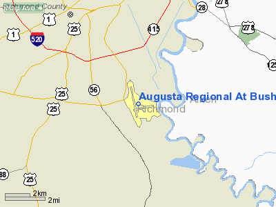
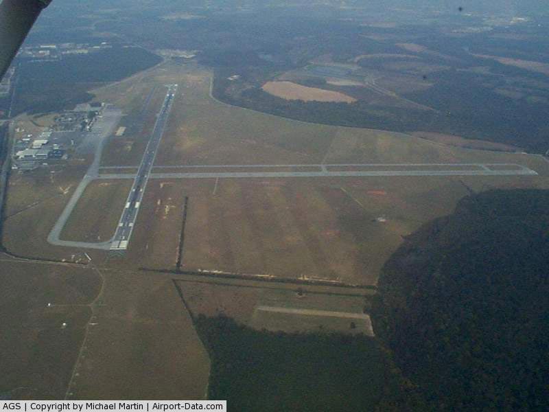
Augusta Regional Airport (IATA: AGS, ICAO: KAGS, FAA LID: AGS), also known as Augusta Regional Airport at Bush Field, is a city-owned, public-use airport located six nautical miles (11 km) south of the central business district of Augusta, a city in Richmond County, Georgia, United States. In 2000, Bush Field airport changed its name to Augusta Regional Airport. The airport recently opened a brand new passenger terminal, and renovated the entire property for ease of use and convenience. Augusta Regional Airport, served by American Eagle, Delta Connection, and US Airways Express, utilizes the phrase "Fly There, Fly Home" as part of their marketing. Lower fares at Augusta Regional Airport have increased passenger usage significantly during the past two years. Facilities and aircraftAugusta Regional Airport covers an area of 1,411 acres (571 ha) at an elevation of 144 feet (44 m) above mean sea level. It has two asphalt paved runways: 17/35 measuring 8,000 x 150 feet (2,438 x 46 m) and 8/26 measuring 6,001 x 75 feet (1,829 x 23 m). For the 12-month period ending December 31, 2006, the airport had 31,647 aircraft operations, an average of 86 per day: 52% general aviation, 25% air taxi, 13% military and 10% scheduled commercial. At that time there were 18 aircraft based at this airport: 56% single-engine, 28% multi-engine and 17% jet. Commercial aircraftIn early 2008, a typical day found seven daily departures to Atlanta, GA using Bombardier CRJ-200 regional jets and ATR 72 turboprop aircraft by Delta Connection carriers, US Airways Express offered seven daily departures to Charlotte, NC with turboprop Bombardier Dash 8-300 aircraft and Bombardier CRJ-200's. As of mid-2009, Delta Air Lines regional carrier Atlantic Southeast Airlines (ASA) no longer operates the ATR-72 turboprop aircraft, and all flights into and out of Augusta are operated with 50-seat CRJ-200 regional jets. US Airways Express continues to serve the airport with Dash 8-100 and -300 turboprops, in addition to CRJ-200s. During the Masters golf tournament, traffic demand through Augusta soars. Airlines have typically responded with more frequent flights with larger equipment, including Delta Air Lines Boeing 737 and 757 aircraft to accommodate this demand. During the 2009 Masters week, Embraer ERJ-170s and CRJ-900s could be seen more commonly, but larger aircraft were also sent to Augusta. The presence of Fort Gordon in Augusta results in periodic military charter flights using widebody aircraft such as McDonnell Douglas DC-10 and McDonnell Douglas MD-11 trijet aircraft operated by World Airways. Airlines and destinations
History
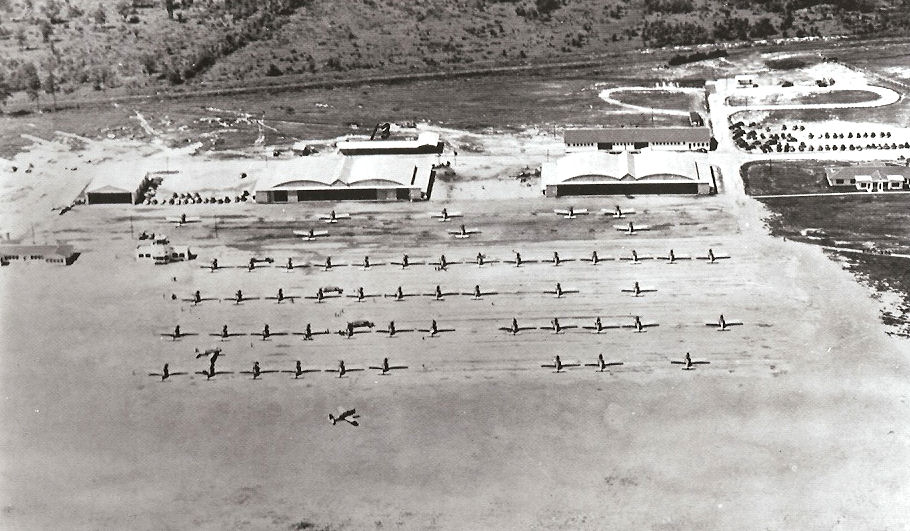
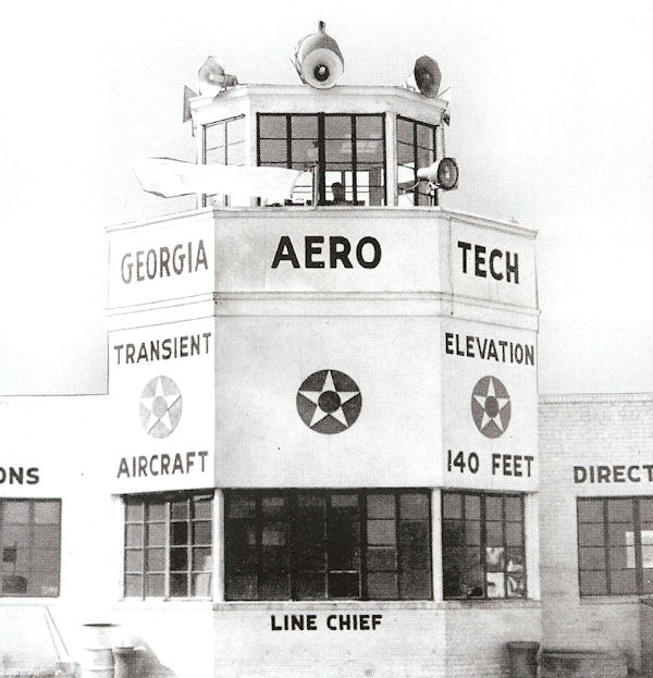
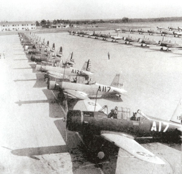
OriginsIn 1941 the City of Augusta learned that the United States Army Air Corps was looking for a site to locate a basic Contract Pilot School. In March 1941 the president of the Chamber of Commerce contacted Harold S. Darr, who operated a primary flight school for the Air Corps in Albany, Georgia (Albany Army Airfield) to promote the idea to locate the new school in the Augusta area. With the Army's approval, Darr chose a 900-acre (3.6 km) tract 7.5 miles (12.1 km) southeast of the City adjacent to the Savannah River. On 22 March 1941, Darr entered into an agreement with local officials to invest $500,000 in buying the acreage and building a school. Darr estimated that the school would employ 300 civilians with an annual payroll of $1.5 million, In turn, the City and Richmond County agreed to move a City-owned hangar from nearby Daniel Field, pave the aircraft parking ramp, pave a road in the area to create a runway, and provide convict labor with guards. The Air Corps set a very ambitious timetable by requiring that flight training begin no Later than 7 June 1941. Construction started on 1 April. The Air Corps and Darr did not go public with the project until 5 April, when an announcement appeared in the local newspaper. World War IITraining began on 10 June, with flying cadets arriving from the Air Corps primary schools at Albany and Americus, Georgia, Tuscaloosa, Alabama, Camden, South Carolina, and Arcadia and Lakeland, Florida. The initial aircraft complement numbered 24 Vultee BT-13 Valiant and BT-15 aircraft. The ten-week course consisted of 70 hours of flight training and 150 hours of ground training. Harold Darr named the school Georgia Acro Tech; however, the Army designated it the 72nd Army Air Force Flight Training Detachment. The school was one of only three contract pilot schools conducting basic training. Shortly after flight training commenced in June 1941, Don C. Bush, a civilian flight instructor lost his life in an aircraft crash. The airfield was named Bush Field in his memory. In January 1942, the Defense Plant Corporation, a corporation entity of the Federal government, bought the school from Harold Darr. With the United States now in the war, the size of the classes increased, requiring an expansion of the school's facilities. Construction began on a ground training building in May and an additional barracks in June. The number of aircraft assigned to the school grew from 24 to around 100 BT-13s and BT-15s. Additional paved runways were eventually added. During all 1943, the school operated at its maximum capacity with classes averaging around 160 students. By early 1944, training requirements began to decrease, and with the possibility at that time of closing nearby Camp Gordon, the Army suddenly had no use for the field. In September 1944, the Air Force closed the facility after training over 5,000 students. Following the war, the Reconstruction Finance Corporation used Bush Field until 1948 for the disposal and sale of surplus military aircraft. The surplus aircraft at Bush ran the gauntlet of practically every model operated by the Army and the Navy, from primary trainers and drones to B-24s and large transports. Several of these were purchased by the upstart Flying Tiger Airline. Commercial useBush Field became Augustaâs commercial airport on 1 July 1950 when the Federal Government transferred Bush Field to the City of Augusta. The same day, the airlines moved their operations from Daniel Field to Bush Field. One of the airportâs most profitable initiatives occurred in 1955 when a transient terminal was opened to sell fuel and to provide service to visiting aircraft. To this day, the fueling operation continues as a major source of revenue for the airport, keeping it self-sufficient and profitable. This is one of the reasons why no tax dollars or City funding has ever been needed to support the airport. Throughout the 1950s and 1960s passenger traffic grew. The old flight school barracks were renovated and leased to Continental Hotels. In 1961, an 8,000 ft (2,400 m). runway was completed. By 1964, Bush Field was one of the country's relatively busy airports, ranking 135th in the nation. Daily jet service at the airport began in 1965 and passenger traffic began to skyrocket. By the close of the 1960s the airport had doubled its baggage claim area and added a terminal, a tower, a lobby, a hotel, parking meters, and a second runway. Just as the 1960s proved to be Bush Field's commercial growth era, the 1970s were the airportâs industrial growth period. During the 1970s Capitol Aviation of Georgia established itself at the airport with a million-dollar-plus airplane service facility. The company, now known as Landmark Aviation, developed a jet engine repair facility, an avionics-navigation shop and a structural and aircraft systems repair shop. Today, Landmark Aviation employs roughly 220 people at the Augusta facility. By the 1990s Bush Field tenants and visitors were contributing approximately $290 million in annual economic activity with nearly 2,200 jobs attributed to the airport. In 2000, Bush Field was renamed Augusta Regional Airport at Bush Field. The self-sufficient airport, which has never used tax dollars to offset any of its projects or programs, completed the first-ever "Master Plan" in 2002. The Master Plan serves as a road map for future economic growth and development at and around the airport. Several former World War II buildings of Georgia Aero Tech remain at Bush Field. The former mess hall, administration building, and ground school buildings form part of the airport's terminal building. The original swimming pool is still in use, but with a motel built around it rather than cadet barracks. The FAA currently occupies the former link trainer building. All the hangars are still in use â including the one moved from Daniel Field in 1941. The above content comes from Wikipedia and is published under free licenses – click here to read more.
Runway InformationRunway 08/26
Runway 17/35
Radio Navigation Aids
Remarks
Based Aircraft
Major Carriers Serving This Airport
Most Popular Destinations
Most Popular Aircraft
Operational StatisticsTime Period: 2004-12-01 - 2005-11-30
Augusta Regional At Bush Field Airport Address: Richmond County, GA Tel: 706-798-2656, 706-798-3236 Images
and information placed above are from We thank them for the data!
We don't guarantee the information is fresh and accurate. The data may
be wrong or outdated.
|
||||||||||||||||||||||||||||||||||||||||||||||||||||||||||||||||||||||||||||||||||||||||||||||||||||||||||||||||||||||||||||||||||||||||||||||||||||||||||||||||||||||||||||||||||||||||||||||||||||||||||||||||||||||||||||||||||||||||||||||||||||||||||||||||||||||||||||||||||||||||||||||||||||||||||||||||||||||||||||||||||||||||||||||||||||||||||||||||||||||||||||||||||||||||||||||||||||||||||||||||||||||||||||||||||||||||||||||||||||||||||||||||||

 |
|
|