 |
|
Zephyrhills Municipal Airport |
| Zephyrhills Municipal Airport |
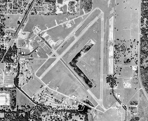 |
| USGS aerial image, 5 January 1999 |
| IATA: ZPH – ICAO: KZPH – FAA LID: ZPH |
| Summary |
| Airport type |
Public |
| Owner |
City of Zephyrhills |
| Serves |
Zephyrhills, Florida |
| Elevation AMSL |
90 ft / 27 m |
| Coordinates |
28°13′41″N 082°09′21″W / 28.22806°N 82.15583°W / 28.22806; -82.15583 |
| Runways |
| Direction |
Length |
Surface |
| ft |
m |
| 4/22 |
4,999 |
1,524 |
Asphalt |
| 18/36 |
4,954 |
1,510 |
Asphalt |
| Statistics (2008) |
| Aircraft operations |
37,750 |
| Based aircraft |
48 |
| Source: Federal Aviation Administration |
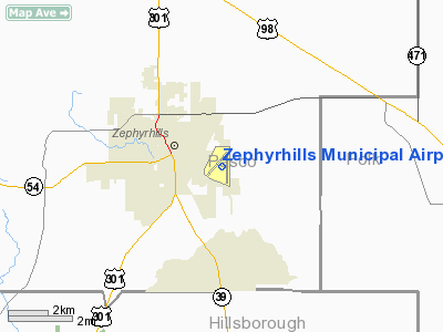
Zephyrhills Municipal Airport (IATA: ZPH, ICAO: KZPH, FAA LID: ZPH) is a city-owned, public-use airport located one nautical mile (1.85 km) southeast of the central business district of Zephyrhills, a city in Pasco County, Florida, United States. History
Opened in January 1943, as a sub-base of Alachua AAF. The airport was hosted by the 372d Army Air Force Base Unit under the Air University Army Air Forces School of Applied Tactics (AAFSAT) tactical combat simulation school in Central and Northern Florida.
Headquartered at Orlando Army Air Base, the school's mission was to develop tactics and techniques of aerial warfare and to establish technical and tactical proficiency requirements for combat units to effectively engage and defeat enemy air forces. This was done with a wide variety of aircraft, including heavy strategic bombers; tactical fighters; medium and light bombers; reconnaissance and dive bombers, based at different airfields of the school.
The airfield was used by the 10th Fighter Squadron (Special), which initially flew P-40 Warhawks at the airfield from 4 January 1943-29 January 1944. The airfield was used to train pilots in ground intercept missions. In July 1943, the squadron converted to P-51 Mustangs. Zephyrhills AAF was also used as a standby landing strip for other USAAF aircraft flying in the area.
The military use of the airport ended on 31 October 1944 and in 1947 the airport was deeded to the city, which has run it ever since.
Facilities and aircraft
Zephyrhills Municipal Airport covers an area of 813 acres (329 ha) at an elevation of 90 feet (27 m) above mean sea level. It has two asphalt paved runways: 4/22 is 4,999 by 100 feet (1,524 x 30 m) and 18/36 is 4,954 by 100 feet (1,510 x 30 m).
For the 12-month period ending November 5, 2008, the airport had 37,750 aircraft operations, an average of 103 per day: 98% general aviation, 2% military, and <1% air taxi. At that time there were 48 aircraft based at this airport: 75% single-engine, 8.3% multi-engine, 10.4% glider and 6.2% ultralight.
Skydiving
This airport has a long history of skydiving, possibly the longest continuous history of skydiving at any U.S. airport. Skydive City, Inc., founded in 1990, operates a skydiving center, or drop zone, on the southeast side of the airport. The predecessor drop zone was Phoenix Parachute Center, operated by George Kabeller, just north of the current drop zone. Prior to that, a drop zone was operated on the southwest side of the airport. Jim Hooper became the manager of Zephyrhills Parachute Center in December, 1976. Si Fraser owned The Zephyrhills Parachute Center. The drop zone was previously managed by Searles.
Accidents and incidents
- On 20 April 1993, Douglas C-47B N8056 of Phoenix Air was written off in a wheels-up landing at Zephyrhills following an engine failure while engaged in a parachuting flight based at the airport. An investigation by the NTSB found that the aircraft should have been able to climb on one engine. The pilot's type rating for the DC-3 was suspended following the accident with the requirement that he should pass a Federal Aviation Authority proficiency check before it was restored.
The above content comes from Wikipedia and is published under free licenses – click here to read more.
Location
& QuickFacts
|
FAA Information Effective: |
2007-01-18 |
|
Airport
Identifier: |
ZPH |
|
Airport
Status: |
Operational |
|
Longitude/Latitude: |
082-09-21.2200W/28-13-41.5000N
-82.155894/28.228194 (Estimated) |
|
Elevation: |
90
ft / 27.43 m (Surveyed) |
|
Land: |
813 acres |
|
From
nearest city: |
1 nautical miles SE of Zephyrhills, FL |
|
Location: |
Pasco County, FL |
|
Magnetic Variation: |
03W (1990) |
Owner
& Manager
|
Ownership: |
Publicly owned |
|
Owner: |
City Of Zephyrhills |
|
Address: |
5335 8th St.
Zephrhills, FL 33540 |
|
Phone
number: |
813-788-2313 |
|
Manager: |
James A Werme |
|
Address: |
39450 South Ave., Box 2
Zephrhills, FL 33540 |
|
Phone number: |
813-780-0030
ARPT PHONE 813-714-6799 |
Airport
Operations and Facilities
|
Airport Use: |
Open to public |
|
Wind
indicator: |
Yes |
|
Segmented
Circle: |
Yes |
|
Control
Tower: |
No |
|
Lighting
Schedule: |
DUSK-DAWN
HIRL RY 18/36 & MIRL RY 04/22 PRESET ON LOW INTST DUSK-2200;
TO INCR INTST & ACTVT AFTER 2200 - CTAF.
ACTVT
PAPI RYS 04 & 22 - CTAF. |
|
Beacon
Color: |
Clear-Green (lighted land airport) |
|
Landing
fee charge: |
No |
|
Sectional
chart: |
Jacksonville |
|
Region: |
ASO - Southern |
|
Boundary
ARTCC: |
ZJX - Jacksonville |
|
Responsible
ARTCC: |
ZMA - Miami |
|
Tie-in
FSS: |
PIE - Saint Petersburg |
|
FSS
on Airport: |
No |
|
FSS
Toll Free: |
1-800-WX-BRIEF |
|
NOTAMs
Facility: |
PIE (NOTAM-d service avaliable) |
|
Federal Agreements: |
NGPRY3 |
Airport
Communications
|
CTAF: |
123.075 |
|
Unicom: |
123.075 |
Airport
Services
|
Fuel available: |
100LLA
24 HR CREDIT CARD FUEL AVAILABLE. |
|
Airframe Repair: |
MINOR |
|
Power Plant Repair: |
MAJOR |
|
Bottled
Oxygen: |
NONE |
|
Bulk
Oxygen: |
NONE |
|
Runway Information
Runway 04/22
|
Dimension: |
5001
x 100 ft / 1524.3 x 30.5 m
25' PAVED SHOULDERS.
37.5
FT PAVED SHOULDERS. |
|
Surface: |
ASPH, Good Condition |
|
Weight
Limit: |
Single wheel: 30000 lbs.
Dual wheel: 60000 lbs.
LIMITED BY AMGR TO MAX GWT OF 24000 LBS OR LESS. |
|
Edge
Lights: |
Medium |
|
|
Runway 04 |
Runway 22 |
|
Longitude: |
082-09-49.5500W |
082-09-11.6400W |
|
Latitude: |
28-13-26.9500N |
28-14-03.3500N |
|
Elevation: |
84.00
ft |
87.00
ft |
|
Alignment: |
43 |
127 |
|
Traffic
Pattern: |
Left |
Right |
|
Markings: |
Non-precision instrument, Poor Condition |
Non-precision instrument, Poor Condition |
|
Crossing
Height: |
32.00
ft |
32.00
ft |
|
VASI: |
4-light PAPI on left side |
4-light PAPI on left side |
|
Visual
Glide Angle: |
3.00� |
3.00� |
|
Obstruction: |
47 ft trees, 1800.0 ft from runway, 450 ft
right of centerline, 34:1 slope to clear |
24 ft pline, 1016.0 ft from runway, 34:1 slope
to clear |
|
Runway 18/36
|
Dimension: |
5072
x 100 ft / 1545.9 x 30.5 m
25' PAVED SHOULDERS.
37.5
FT PAVED SHOULDERS. |
|
Surface: |
ASPH, Good Condition |
|
Weight
Limit: |
Single wheel: 29000 lbs.
Dual wheel: 49000 lbs.
LIMITED BY AMGR TO MAX GWT OF 24000 LBS OR LESS. |
|
Edge
Lights: |
High |
|
|
Runway 18 |
Runway 36 |
|
Longitude: |
082-09-11.8300W |
082-09-12.1300W |
|
Latitude: |
28-14-03.0100N |
28-13-12.7900N |
|
Elevation: |
87.00
ft |
77.00
ft |
|
Alignment: |
127 |
0 |
|
Traffic
Pattern: |
Right |
Left |
|
Markings: |
Basic, Good Condition
RY 18/36 NO RY END MARKINGS. |
Basic, Good Condition |
|
Displaced
threshold: |
380.00
ft |
300.00
ft |
|
Obstruction: |
31 ft trees, 1200.0 ft from runway, 32:1 slope
to clear
RY 18 APCH RATIO 50:1 FROM DSPLCD THLD. |
28 ft trees, 1128.0 ft from runway, 33:1 slope
to clear
RY 36 APCH RATIO 50:1 FROM DSPLCD THLD. |
|
Radio Navigation
Aids
|
ID |
Type |
Name |
Ch |
Freq |
Var |
Dist |
|
PCM |
NDB |
Plant City |
|
346.00 |
02W |
13.6 nm |
|
TPF |
NDB |
Knight |
|
270.00 |
02W |
24.9 nm |
|
AM |
NDB |
Picny |
|
388.00 |
02W |
30.2 nm |
|
ISM |
NDB |
Kissimmee |
|
329.00 |
05W |
38.4 nm |
|
LEE |
NDB |
Leesburg |
|
335.00 |
04W |
40.0 nm |
|
CHN |
NDB |
Wauchula |
|
261.00 |
04W |
45.5 nm |
|
MCF |
TACAN |
Macdill |
047X |
|
04W |
29.1 nm |
|
LAL |
VORTAC |
Lakeland |
107X |
116.00 |
01E |
16.4 nm |
|
PIE |
VORTAC |
St Petersburg |
111X |
116.40 |
01E |
34.0 nm |
|
ORL |
VORTAC |
Orlando |
059X |
112.20 |
00E |
47.3 nm |
|
TPA |
VOT |
Tampa Intl |
|
111.00 |
|
25.1 nm |
Remarks
- RY
22 24' PLINE CROSSES APCH 800-1300' FROM RY END; MKD WITH RED FLAGS.
- TWY
'B' HAS MANY DEPRESSIONS IN SFC.
- GLIDER
OPNS SR-SS.
- BE
ALERT FOR SKY-DIVING ACFT DESCENDING FROM 13500 FT & ENTERING OPPOSITE
TFC PAT FOR RY 18/36 E OF ARPT.
- EXISTED
PRIOR TO 1959.
Based
Aircraft
|
Aircraft
based on field: |
90 |
|
Single
Engine Airplanes: |
64 |
|
Multi
Engine Airplanes: |
18 |
|
Gliders: |
5 |
|
Ultralights: |
3 |
Operational Statistics
Time Period: 1998-07-01
- 1999-06-30
|
Aircraft
Operations: |
104/Day |
|
Air Taxi: |
0.4% |
|
General
Aviation Local: |
60.9% |
|
General
Aviation Itinerant: |
37.1% |
|
Military: |
1.6% |
Zephyrhills Municipal Airport
Address:
Pasco County, FL
Tel:
813-788-2313,
813-780-0030
Images
and information placed above are from
http://www.airport-data.com/airport/ZPH/
We
thank them for the data!
| General
Info |
| Country |
United
States |
| State |
FLORIDA
|
| FAA ID |
ZPH
|
| Latitude |
28-13-41.033N
|
| Longitude |
082-09-21.299W
|
| Elevation |
90 feet
|
| Near City |
ZEPHYRHILLS
|
We don't guarantee the information is fresh and accurate. The data may
be wrong or outdated.
For more up-to-date information please refer to other sources.
|
|


