 |
|
Coordinates: 27°10′54.10″N 080°13′15.90″W / 27.181694°N 80.221083°W / 27.181694; -80.221083
| Witham Field |
| IATA: SUA – ICAO: KSUA – FAA LID: SUA |
| Summary |
| Airport type |
Public use |
| Owner |
Martin County Board of Commissioners |
| Operator |
Michael C. Moon |
| Serves |
Stuart, Florida |
| Location |
Martin County, Florida |
| Elevation AMSL |
18 ft / 6 m |
| Website |
Martin County Airport |
| Runways |
| Direction |
Length |
Surface |
| ft |
m |
| 7/25 |
4,652 |
1,418 |
Asphalt |
| 12/30 |
5,826 |
1,776 |
Asphalt |
| 16/34 |
5,000 |
1,524 |
Asphalt |
| Statistics (1999) |
| Aircraft operations |
120,556 |
| Based aircraft |
235 |
| Source: Federal Aviation Administration |
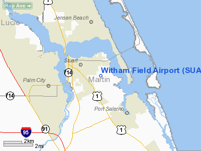
Witham Field (IATA: SUA, ICAO: KSUA, FAA LID: SUA) is a public-use airport located 1 mile (1.6 km) southeast of the central business district of the city of Stuart in Martin County, Florida, United States. The airport is publicly owned.
History
With the onset of World War II, patriotic private landowners offered their property to Martin County to build an airport. Martin County's airport was originally known as MacArthur Field, however, it was later named Witham Field in honor of Paul "Homer" Witham, who was the first Naval Aviator from the City of Stuart to die in World War II.
In October of 1942, Martin County leased the 900-acre (3.6 km) airport to the U.S. Government for use as a military training field. The U.S. Navy assumed operation of the airport in exchange for an $800,000 payment to the County. The Navy then committed $10 million to construct and operate a modern naval air station. During the war years, Naval Auxiliary Air Station Witham Field operated as an auxiliary field to Naval Air Station Vero Beach, providing an additional training and proficiency facility for Naval Aviators from the U.S. Navy and U.S. Marine Corps operating carrier-based and land-based fighter and light bomber aircraft.
On July 1, 1947, NAAS Witham Field was decommissioned and the property returned to Martin County. During the 1950s and 1960s, Grumman Aircraft Corporation, now known as Northrop Grumman Space and Mission Systems Corporation, leased much of the airport property, naming it "Plant 77" and conducting flight-testing and manufacturing of parts and subassemblies for various aircraft such as the U.S. Army's OV-1 Mohawk and various U.S. Navy, U.S. Marine Corps and U.S. Coast Guard aircraft.
In 1994, Northrop Grumman downsized their Witham Field operation and much of the property was again returned to Martin County, including responsibility for the airport's air traffic control tower. The county, in turn, hired an Airport Director to manage the property. Martin County now operates the 726-acre (2.94 km) airport, and although there is no scheduled commercial airline service at the airport, the facility does continue to maintain an operational air traffic control tower and is home to two fixed base operators (FBO) and more than 200 private and business aircraft.
The above content comes from Wikipedia and is published under free licenses – click here to read more.
Location
& QuickFacts
|
FAA Information Effective: |
2007-01-18 |
|
Airport
Identifier: |
SUA |
|
Airport
Status: |
Operational |
|
Longitude/Latitude: |
080-13-15.9000W/27-10-54.1000N
-80.221083/27.181694 (Estimated) |
|
Elevation: |
18
ft / 5.49 m (Surveyed) |
|
Land: |
739 acres |
|
From
nearest city: |
1 nautical miles SE of Stuart, FL |
|
Location: |
Martin County, FL |
|
Magnetic Variation: |
05W (2000) |
Owner
& Manager
|
Ownership: |
Publicly owned |
|
Owner: |
Martin County Board Of Cmsnrs |
|
Address: |
1871 Se Airport Road
Stuart, FL 34996 |
|
Phone
number: |
772-221-2301 |
|
Manager: |
Michael C. Moon |
|
Address: |
1871 Se Airport Road
Stuart, FL 34996 |
|
Phone number: |
772-221-2374 |
Airport
Operations and Facilities
|
Airport Use: |
Open to public |
|
Wind
indicator: |
Yes |
|
Segmented
Circle: |
No |
|
Control
Tower: |
Yes |
|
Lighting
Schedule: |
DUSK-DAWN
MIRL RYS 12/30 & 07/25 PRESET MED INTST DUSK-2300. ACTVT
REIL RYS 12 & 30 AND AFTER 2300, ACTVT MIRL RYS 12/30
& 07/25 - CTAF.
PAPI RYS 12, 30, 07, & 25 OPER CONT. |
|
Beacon
Color: |
Clear-Green (lighted land airport) |
|
Landing
fee charge: |
No |
|
Sectional
chart: |
Miami |
|
Region: |
ASO - Southern |
|
Boundary
ARTCC: |
ZMA - Miami |
|
Tie-in
FSS: |
MIA - Miami |
|
FSS
on Airport: |
No |
|
FSS
Phone: |
305-233-2600 |
|
FSS
Toll Free: |
1-800-WX-BRIEF |
|
NOTAMs
Facility: |
MIA (NOTAM-d service avaliable) |
|
Federal Agreements: |
NGRY3 |
Airport
Communications
Airport
Services
|
Fuel available: |
100LLA |
|
Airframe Repair: |
MAJOR |
|
Power Plant Repair: |
MAJOR |
|
Bottled
Oxygen: |
NONE |
|
Bulk
Oxygen: |
NONE |
|
Runway Information
Runway 07/25
|
Dimension: |
4652 x 100 ft / 1417.9 x 30.5 m |
|
Surface: |
ASPH, Fair Condition |
|
Weight
Limit: |
Single wheel: 58000 lbs.
Dual wheel: 95000 lbs.
Dual
tandem wheel: 170000 lbs. |
|
Edge
Lights: |
Medium |
|
|
Runway 07 |
Runway 25 |
|
Longitude: |
080-13-44.4600W |
080-12-56.5800W |
|
Latitude: |
27-10-54.0400N |
27-11-11.0600N |
|
Elevation: |
17.00 ft |
12.00 ft |
|
Alignment: |
68 |
127 |
|
Traffic
Pattern: |
Left |
Left |
|
Markings: |
Basic, Good Condition |
Basic, Good Condition |
|
Displaced
threshold: |
0.00 ft |
400.00
ft |
|
VASI: |
2-light PAPI on left side |
2-light PAPI on left side |
|
Obstruction: |
29 ft , 1200.0 ft from runway, 34:1 slope to
clear |
70 ft trees, 1400.0 ft from runway, 17:1 slope
to clear
APCH SLOPE 25:1 TO DSPLCD THLD. |
|
Runway 12/30
|
Dimension: |
5826 x 100 ft / 1775.8 x 30.5 m |
|
Surface: |
ASPH, Good Condition |
|
Surface
Treatment: |
Saw-cut or plastic Grooved |
|
Weight
Limit: |
Single wheel: 65000 lbs.
Dual wheel: 105000 lbs.
Dual
tandem wheel: 190000 lbs. |
|
Edge
Lights: |
Medium |
|
|
Runway 12 |
Runway 30 |
|
Longitude: |
080-13-53.2200W |
080-12-52.7000W |
|
Latitude: |
27-10-55.0600N |
27-10-35.0700N |
|
Elevation: |
16.00 ft |
14.00 ft |
|
Alignment: |
110 |
127 |
|
Traffic
Pattern: |
Left |
Left |
|
Markings: |
Non-precision instrument, Good Condition |
Non-precision instrument, Good Condition |
|
Crossing
Height: |
33.00
ft |
26.00
ft |
|
Displaced
threshold: |
660.00
ft |
460.00
ft |
|
VASI: |
4-light PAPI on left side |
4-light PAPI on left side |
|
Visual
Glide Angle: |
3.00� |
3.00� |
|
Runway
End Identifier: |
Yes |
Yes |
|
Obstruction: |
50 ft trees, 600.0 ft from runway, 8:1 slope
to clear
APCH SLOPE 21:1 TO DSPLCD THLD. |
37 ft trees, 570.0 ft from runway, 10:1 slope
to clear
APCH SLOPE 27:1 TO DSPLCD THLD. |
|
Runway 16/34
|
Dimension: |
5000 x 100 ft / 1524.0 x 30.5 m |
|
Surface: |
ASPH, Fair Condition |
|
Weight
Limit: |
Single wheel: 55000 lbs.
Dual wheel: 90000 lbs.
Dual
tandem wheel: 160000 lbs. |
|
|
Runway 16 |
Runway 34 |
|
Longitude: |
080-13-17.9100W |
080-12-53.9700W |
|
Latitude: |
27-11-18.6500N |
27-10-34.0000N |
|
Elevation: |
14.00 ft |
14.00 ft |
|
Alignment: |
127 |
127 |
|
Traffic
Pattern: |
Left |
Left |
|
Markings: |
Basic, Good Condition |
Basic, Good Condition |
|
Displaced
threshold: |
335.00
ft |
880.00
ft |
|
Obstruction: |
41 ft , 1230.0 ft from runway, 25:1 slope to
clear |
35 ft trees, 870.0 ft from runway, 19:1 slope
to clear
APCH RATIO 50:1 TO DSPLCD THLD. |
|
Radio Navigation
Aids
|
ID |
Type |
Name |
Ch |
Freq |
Var |
Dist |
|
UTX |
NDB |
United |
|
405.00 |
03W |
17.5 nm |
|
FPR |
NDB |
Fort Pierce |
|
275.00 |
04W |
20.1 nm |
|
PB |
NDB |
Rubin |
|
356.00 |
03W |
29.7 nm |
|
VEP |
NDB |
Vero Beach |
|
392.00 |
04W |
30.9 nm |
|
PBI |
VORTAC |
Palm Beach |
104X |
115.70 |
03W |
31.0 nm |
|
VRB |
VORTAC |
Vero Beach |
120X |
117.30 |
04W |
33.1 nm |
|
PHK |
VORTAC |
Pahokee |
101X |
115.40 |
00E |
34.8 nm |
|
VRB |
VOT |
Vero Beach |
|
111.00 |
|
30.2 nm |
|
PBI |
VOT |
Palm Beach |
|
109.00 |
|
30.4 nm |
Remarks
- ACFT
WITH WING SPANS EXCEEDING 79 FT ARE PROHIBITED FROM OPERG ON TWY 'A'
BET TWY 'C' AND THE APCH END RY 12 WHEN ACFT WITH WING SPAN EXCEEDING
79 FT IS ON APCH TO, LNDG, OR TAKING OFF RY 12/30.
- BIRDS
ON & IVOF ARPT.
- NOISE
SENSITIVE AREAS ALL QUADRANTS. USE NOISE ABATEMENT PROCEDURES AS PRESCRIBED
BY ARPT & THE NATIONAL BUSINESS ACFT ASSOCIATION.
- TOUCH
& GO OPNS PERMITTED MON-SAT (EXCP NEW YEARS, CHRISTMAS & THANKSGIVING)
0900 UNTIL 2 HRS PAST SS AND ARE LIMITED TO 3 OPNS PER PILOT PER DAY.
- STOP
& GO OPNS AND INTXN TKOFS STRONGLY DISCOURAGED AT ALL TIMES.
- STAGE
1 & 2 JET OPNS STRONGLY DISCOURAGED 2200-0700.
- PPR
FOR ACFT EXCEEDING RY WT CPTY.
- EXISTED
PRIOR TO 1959.
Based Aircraft
|
Aircraft
based on field: |
235 |
|
Single
Engine Airplanes: |
179 |
|
Multi
Engine Airplanes: |
39 |
|
Jet Engine
Airplanes: |
14 |
|
Helicopters: |
3 |
Operational Statistics
Time Period: 1998-07-15
- 1999-07-14
|
Aircraft
Operations: |
331/Day |
|
Air Taxi: |
3.7% |
|
General
Aviation Local: |
43.8% |
|
General
Aviation Itinerant: |
52.3% |
|
Military: |
0.2% |
Witham Field Airport
Address:
Martin County, FL
Tel:
772-221-2301,
772-221-2374
Images
and information placed above are from
http://www.airport-data.com/airport/SUA/
We
thank them for the data!
| General
Info |
| Country |
United
States |
| State |
FLORIDA
|
| FAA ID |
SUA
|
| Latitude |
27-10-54.100N
|
| Longitude |
080-13-15.900W
|
| Elevation |
18 feet
|
| Near City |
STUART
|
We don't guarantee the information is fresh and accurate. The data may
be wrong or outdated.
For more up-to-date information please refer to other sources.
|
|


