|
|
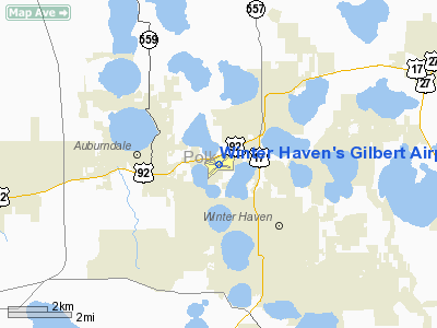
Winter Haven's Gilbert Airport |
Winter Haven's Gilbert Airport
Winter Haven Municipal Airport |
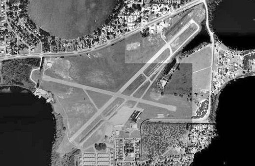 |
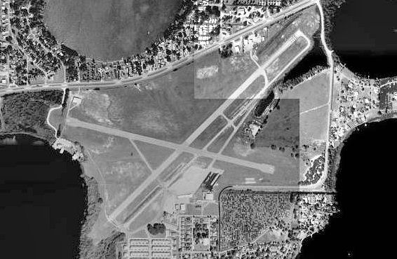
| USGS aerial image - 30 Jan 1999 |
| IATA: GIF – ICAO: KGIF – FAA LID: GIF |
| Summary |
| Airport type |
Public |
| Owner |
City of Winter Haven |
| Serves |
Winter Haven, Florida |
| Elevation AMSL |
145 ft / 44 m |
| Coordinates |
28°03′46″N 081°45′12″W / 28.06278°N 81.75333°W / 28.06278; -81.75333 |
| Runways |
| Direction |
Length |
Surface |
| ft |
m |
| 5/23 |
5,005 |
1,526 |
Asphalt |
| 11/29 |
4,001 |
1,220 |
Asphalt |
| Statistics (2008) |
| Aircraft operations |
60,000 |
| Based aircraft |
169 |
| Source: Federal Aviation Administration |
Winter Haven's Gilbert Airport (IATA: GIF, ICAO: KGIF, FAA LID: GIF) is a city-owned, public-use airport located three nautical miles (6 km) northwest of the central business district of Winter Haven, a city in Polk County, Florida, United States. It is owned by the City of Winter Haven. It is also known as Winter Haven Municipal Airport or Gilbert Field. Jack Browns Seaplane Base is located adjacent to the airport, connected by a taxiway.
During World War II, the facility was an Army Air Forces auxiliary airfield to Lakeland AAF/Drane Field, now Lakeland Linder Regional Airport. History
During World War II, Winter Haven Army Airfield (also known as Gilbert Field) was an auxiliary airfield for the Lakeland School of Aeronautics at Lakeland Army Airfield. The school provided basic pilot training to United States Army Air Forces flying cadets from the airfield under contract. Flight training was performed until the end of the war.
Facilities and aircraft
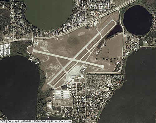
Winter Haven's Gilbert Airport covers an area of 520 acres (210 ha) at an elevation of 145 feet (44 m) above mean sea level. It has two asphalt paved runways: 5/23 is 5,005 by 100 feet (1,526 x 30 m) and 11/29 is 4,001 by 100 feet (1,220 x 30 m).
For the 12-month period ending October 20, 2008, the airport had 60,000 general aviation aircraft operations, an average of 164 per day. At that time there were 169 aircraft based at this airport: 87% single-engine, 10% multi-engine, 1% jet and 2% glider.
The above content comes from Wikipedia and is published under free licenses – click here to read more.
|
 |
(Click on the photo to enlarge) |
Location
& QuickFacts
|
FAA Information Effective: |
2007-01-18 |
|
Airport
Identifier: |
GIF |
|
Airport
Status: |
Operational |
|
Longitude/Latitude: |
081-45-11.9000W/28-03-46.5000N
-81.753306/28.062917 (Estimated) |
|
Elevation: |
145 ft / 44.20 m (Surveyed) |
|
Land: |
520 acres |
|
From
nearest city: |
3 nautical miles NW of Winter Haven, FL |
|
Location: |
Polk County, FL |
|
Magnetic Variation: |
04W (2000) |
Owner
& Manager
|
Ownership: |
Publicly owned |
|
Owner: |
City Of Winter Haven |
|
Address: |
P.o. Box 2277
Winter Haven, FL 33883-2277 |
|
Phone
number: |
863-291-5645 |
|
Manager: |
Cheryl Connor |
|
Address: |
P.o. Box 2277
Winter Haven, FL 33883-2277 |
|
Phone number: |
863-298-4551 |
Airport
Operations and Facilities
|
Airport Use: |
Open to public |
|
Wind
indicator: |
Yes |
|
Segmented
Circle: |
No |
|
Control
Tower: |
No |
|
Lighting
Schedule: |
DUSK-DAWN
ACTVT MIRL RY 04/22, PAPI RYS 04 & 22 - CTAF. |
|
Beacon
Color: |
Clear-Green (lighted land airport) |
|
Landing
fee charge: |
No |
|
Sectional
chart: |
Jacksonville |
|
Region: |
ASO - Southern |
|
Traffic
Pattern Alt: |
855 ft |
|
Boundary
ARTCC: |
ZMA - Miami |
|
Tie-in
FSS: |
PIE - Saint Petersburg |
|
FSS
on Airport: |
No |
|
FSS
Toll Free: |
1-800-WX-BRIEF |
|
NOTAMs
Facility: |
GIF (NOTAM-d service avaliable) |
|
Federal Agreements: |
NGY3 |
Airport
Communications
|
CTAF: |
123.050 |
|
Unicom: |
123.050 |
Airport
Services
|
Fuel available: |
100LLA MOGAS |
|
Airframe Repair: |
MAJOR |
|
Power Plant Repair: |
MAJOR |
|
Bottled
Oxygen: |
NONE |
|
Bulk
Oxygen: |
NONE |
|
Runway Information
Runway 04/22
|
Dimension: |
5006 x 100 ft / 1525.8 x 30.5 m |
|
Surface: |
ASPH, Fair Condition |
|
Weight
Limit: |
Single wheel: 30000 lbs. |
|
Edge
Lights: |
Medium |
|
|
Runway 04 |
Runway 22 |
|
Longitude: |
081-45-28.3506W |
081-44-48.8438W |
|
Latitude: |
28-03-30.6891N |
28-04-05.7351N |
|
Elevation: |
142.00
ft |
141.00
ft |
|
Alignment: |
45 |
127 |
|
Traffic
Pattern: |
Left |
Left |
|
Markings: |
Basic, Good Condition |
Basic, Good Condition |
|
Crossing
Height: |
50.00
ft |
50.00
ft |
|
VASI: |
2-light PAPI on left side |
2-light PAPI on left side |
|
Visual
Glide Angle: |
3.00� |
3.00� |
|
Obstruction: |
20 ft trees, 600.0 ft from runway, 20:1 slope
to clear |
26 ft trees, 720.0 ft from runway, 20:1 slope
to clear |
|
Runway 11/29
|
Dimension: |
4001 x 100 ft / 1219.5 x 30.5 m |
|
Surface: |
ASPH, Good Condition |
|
Weight
Limit: |
Single wheel: 12500 lbs. |
|
|
Runway 11 |
Runway 29 |
|
Longitude: |
081-45-37.8485W |
081-44-54.3636W |
|
Latitude: |
28-03-48.8960N |
28-03-39.8801N |
|
Elevation: |
143.00
ft |
141.00
ft |
|
Alignment: |
103 |
127 |
|
Traffic
Pattern: |
Left |
Left |
|
Markings: |
Basic, Good Condition |
Basic, Good Condition |
|
Obstruction: |
6 ft road, 320.0 ft from runway, 20:1 slope
to clear |
26 ft trees, 700.0 ft from runway, 20:1 slope
to clear |
|
Radio Navigation
Aids
|
ID |
Type |
Name |
Ch |
Freq |
Var |
Dist |
|
ISM |
NDB |
Kissimmee |
|
329.00 |
05W |
21.7 nm |
|
PCM |
NDB |
Plant City |
|
346.00 |
02W |
21.7 nm |
|
RHZ |
NDB |
Zephyrhills |
|
253.00 |
03W |
23.6 nm |
|
CHN |
NDB |
Wauchula |
|
261.00 |
04W |
33.9 nm |
|
TPF |
NDB |
Knight |
|
270.00 |
02W |
38.4 nm |
|
AM |
NDB |
Picny |
|
388.00 |
02W |
43.8 nm |
|
LEE |
NDB |
Leesburg |
|
335.00 |
04W |
45.5 nm |
|
MCF |
TACAN |
Macdill |
047X |
|
04W |
42.1 nm |
|
LAL |
VORTAC |
Lakeland |
107X |
116.00 |
01E |
14.6 nm |
|
ORL |
VORTAC |
Orlando |
059X |
112.20 |
00E |
36.4 nm |
|
TPA |
VOT |
Tampa Intl |
|
111.00 |
|
41.7 nm |
Remarks
- BROWN'S
SPB LOCATED ON ADJACENT LAKE.
- ANEMOMETER
REMOTED TO FBO OFFICE.
- GLIDER
ACFT OPERG ON AND INVOF ARPT.
- GCO
AVBL ON FREQ 121.725 THRU TPA CLEARANCE DELIVERY.
Based
Aircraft
|
Aircraft
based on field: |
160 |
|
Single
Engine Airplanes: |
139 |
|
Multi
Engine Airplanes: |
13 |
|
Jet Engine
Airplanes: |
1 |
|
Helicopters: |
3 |
|
Gliders: |
4 |
Operational Statistics
Time Period: 1998-06-29
- 1999-06-28
|
Aircraft
Operations: |
165/Day |
|
General
Aviation Local: |
58.3% |
|
General
Aviation Itinerant: |
41.7% |
Winter Haven's Gilbert Airport
Address:
Polk County, FL
Tel:
863-291-5645,
863-298-4551
Images
and information placed above are from
http://www.airport-data.com/airport/GIF/
We
thank them for the data!
| General
Info |
| Country |
United
States |
| State |
FLORIDA
|
| FAA ID |
GIF
|
| Latitude |
28-03-46.500N
|
| Longitude |
081-45-11.900W
|
| Elevation |
145 feet
|
| Near City |
WINTER
HAVEN |
We don't guarantee the information is fresh and accurate. The data may
be wrong or outdated.
For more up-to-date information please refer to other sources.
|
|