|
|
Williston Municipal Airport |
| Williston Municipal Airport |
 |
| IATA: none – ICAO: none – FAA LID: X60 |
| Summary |
| Airport type |
Public |
| Owner |
City of Williston |
| Serves |
Williston, Florida |
| Elevation AMSL |
76 ft / 23 m |
| Coordinates |
29°21′21″N 082°28′18″W / 29.35583°N 82.47167°W / 29.35583; -82.47167 |
| Runways |
| Direction |
Length |
Surface |
| ft |
m |
| 5/23 |
6,668 |
2,032 |
Concrete |
| 14/32 |
4,399 |
1,341 |
Asphalt |
| Statistics (2009) |
| Aircraft operations |
16,250 |
| Based aircraft |
52 |
| Source: Federal Aviation Administration |
 | |
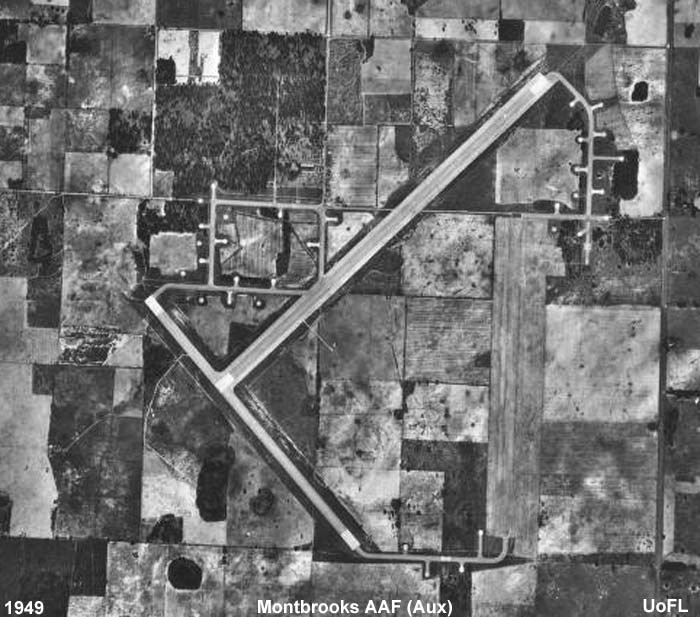
Williston Airport, 1949 (Formerly Montbrook AAF (Auxiliary) |
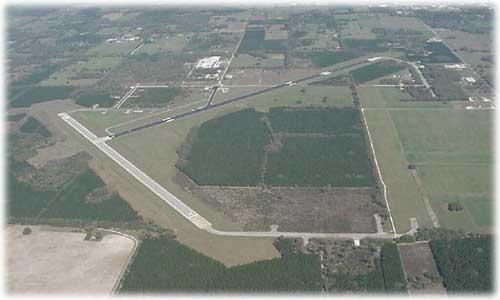
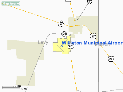
Williston Municipal Airport (FAA LID: X60) is a city-owned, public-use airport located two nautical miles (3.7 km) southwest of the central business district of Williston, a city in Levy County, Florida, United States. Commonly referred to as Williston Airport, it is located 23 miles (37 km) SW of Gainesville Regional Airport (GNV). Opened in 1974 for public use, it does not have a control tower. History
Formerly known as Montbrook Army Air Field during World War II, the airfield was opened as a US Army Air Forces installation on 1 January 1942. Montbrook was a sub-base of Alachua AAF under the Air Technical Service Command. The airfield was very small with only a few personnel assigned. As part of the Army Air Force School of Applied Tactics, it was home to B-17 Flying Fortress, B-24 Liberator and B-25 Mitchell bombers as part of the 99th Bombardment Squadron and P-40 Warhawk fighters as part of the 10th Fighter Squadron.
Known units assigned at Montbrook AAF were:
- 99th Bombardment Squadron, 5 February-14 November 1943 (B-25 Mitchell), (B-26 Marauder)
- 465th Bombardment Squadron, 19 November 1943-2 March 1944 (DB-7 (A-20) Havoc)
On 20 May 1944 the airfield was put on standby status and placed under the control of the 4318th Army Air Force Base Unit (Base Maintenance). It appears to have been closed by the end of 1944.
In 1974, the facility was deeded to the City of Williston. It serves as a basic utility airport in Levy County for the City of Archer, City of Bronson, City of McIntosh, City of Reddick and the City of Williston. It is one of two airports in the county, serving alongside the George T. Lewis Airport in Cedar Key.
A planned upgrade of the airport slowly started with annexation of land in 1988. In 1992, it was selected as a preferred location for a regional airport within 20 miles (32 km). A second, larger, runway was completed by 2002 and allowed for jet aircraft to use the facility. An Automated Weather Observation Station (AWOS) was installed at the airport by the end of 2005. Future upgrades on the 2,000 acre (8 km²) site include additional hangars, a corporate hangar park and a new fixed base operator. As of 2006, the facility averaged only 44 flights per day.
Services available at the airport include painting, upholstery, turbine engine repair and helicopter sales. Within 5 miles (8 km) of the airport are the internationally known dive springs of Devil's Den and Blue Grotto.
Facilities and aircraft
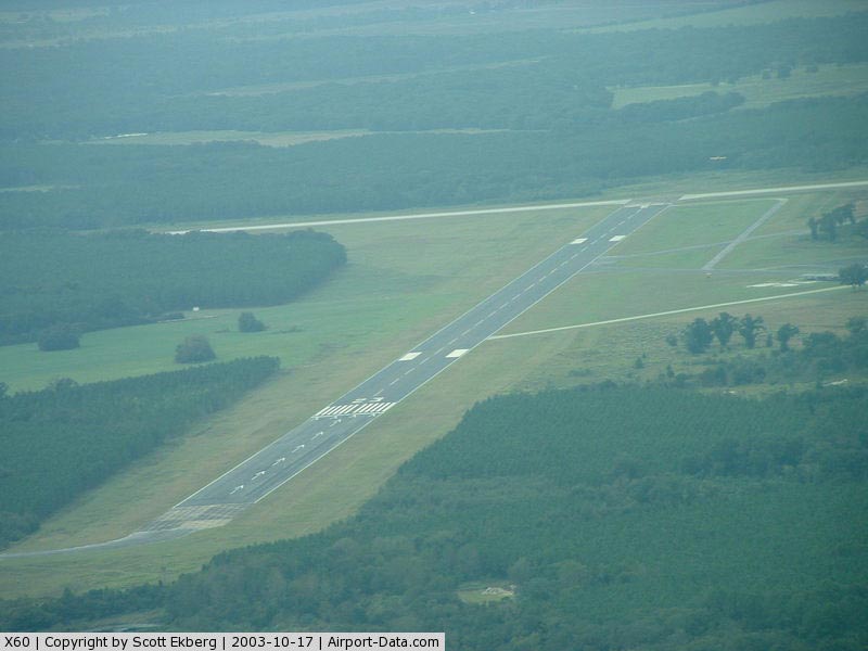
Williston Municipal Airport covers an area of 1,600 acres (647 ha) at an elevation of 76 feet (23 m) above mean sea level. It has two runways: 5/23 is 6,668 by 100 feet (2,032 x 30 m) with a concrete surface; 14/32 is 4,399 by 100 feet (1,341 x 30 m) with an asphalt surface.
For the 12-month period ending February 3, 2009, the airport had 16,250 general aviation aircraft operations, an average of 44 per day. At that time there were 52 aircraft based at this airport: 77% single-engine, 17% multi-engine, 2% helicopter and 4% ultralight.
The above content comes from Wikipedia and is published under free licenses – click here to read more.
|
 |
(Click on the photo to enlarge) |
Location
& QuickFacts
|
FAA Information Effective: |
2007-01-18 |
|
Airport
Identifier: |
X60 |
|
Airport
Status: |
Operational |
|
Longitude/Latitude: |
082-28-22.3800W/29-21-15.1900N
-82.472883/29.354219 (Estimated) |
|
Elevation: |
76
ft / 23.16 m (Surveyed) |
|
Land: |
1600 acres |
|
From
nearest city: |
2 nautical miles SW of Williston, FL |
|
Location: |
Levy County, FL |
|
Magnetic Variation: |
04W (2000) |
Owner
& Manager
|
Ownership: |
Publicly owned |
|
Owner: |
City Of Williston
SYLVIA LANIER: CITY CLERK |
|
Address: |
Po Box 160
Williston, FL 32696 |
|
Phone
number: |
352-528-3060 |
|
Manager: |
Brooks Holloway |
|
Address: |
P.o. Box 160
Williston, FL 32696 |
|
Phone number: |
352-528-3060 |
Airport
Operations and Facilities
|
Airport Use: |
Open to public |
|
Wind
indicator: |
Yes |
|
Segmented
Circle: |
Yes |
|
Control
Tower: |
No |
|
Lighting
Schedule: |
DUSK-DAWN
ACTVT MIRL RY 05/23 - CTAF. |
|
Beacon
Color: |
Clear-Green (lighted land airport) |
|
Landing
fee charge: |
No |
|
Sectional
chart: |
Jacksonville |
|
Region: |
ASO - Southern |
|
Boundary
ARTCC: |
ZJX - Jacksonville |
|
Responsible
ARTCC: |
ZJX - Jacksonville |
|
Tie-in
FSS: |
GNV - Gainesville |
|
FSS
on Airport: |
No |
|
FSS
Phone: |
850-377-3291 |
|
FSS
Toll Free: |
1-800-WX-BRIEF |
|
NOTAMs
Facility: |
GNV (NOTAM-d service avaliable) |
|
Federal Agreements: |
NGPRY |
Airport
Communications
|
CTAF: |
122.800 |
|
Unicom: |
122.800 |
Airport
Services
|
Fuel available: |
100LLA |
|
Airframe Repair: |
MAJOR |
|
Power Plant Repair: |
MAJOR |
|
Bottled
Oxygen: |
NONE |
|
Bulk
Oxygen: |
NONE |
|
Runway Information
Runway 05/23
|
Dimension: |
6390
x 150 ft / 1947.7 x 45.7 m
RY 14/32 25 FT SHOULDERS BOTH SIDES OF RY ENTIRE LENGTH. |
|
Surface: |
ASPH, Good Condition |
|
Weight
Limit: |
Single wheel: 46000 lbs. |
|
Edge
Lights: |
Medium |
|
|
Runway 05 |
Runway 23 |
|
Longitude: |
082-28-35.5800W |
082-27-44.6000W |
|
Latitude: |
29-21-09.2400N |
29-21-54.0500N |
|
Elevation: |
74.00
ft |
71.00
ft |
|
Alignment: |
45 |
127 |
|
Traffic
Pattern: |
Left |
Left |
|
Markings: |
Basic, Good Condition |
Basic, Good Condition |
|
Displaced
threshold: |
0.00 ft |
1366.00 ft
RY 23 DSPLCD THLD UNLGTD. |
|
Obstruction: |
30 ft trees, 950.0 ft from runway, 25:1 slope
to clear |
30 ft trees, 1200.0 ft from runway, 32:1 slope
to clear
RY 23 APCH RATIO 50:1 TO DSPLCD THLD. |
|
Runway 14/32
|
Dimension: |
4330
x 100 ft / 1319.8 x 30.5 m
RY 14/32 25 FT SHOULDERS BOTH SIDES OF RY ENTIRE LENGTH. |
|
Surface: |
ASPH, Good Condition |
|
Weight
Limit: |
Single wheel: 38000 lbs. |
|
|
Runway 14 |
Runway 32 |
|
Longitude: |
082-28-48.3700W |
082-28-15.4200W |
|
Latitude: |
29-21-18.5600N |
29-20-45.9500N |
|
Elevation: |
70.00
ft |
65.00
ft |
|
Traffic
Pattern: |
Left |
Left |
|
Markings: |
Basic, Good Condition |
Basic, Good Condition |
|
Displaced
threshold: |
300.00
ft |
0.00 ft |
|
Obstruction: |
50 ft trees, 800.0 ft from runway, 12:1 slope
to clear
RY 14 APCH RATIO 22:1 FROM DSPLCD THLD. |
30 ft trees, 800.0 ft from runway, 20:1 slope
to clear |
|
Radio Navigation
Aids
|
ID |
Type |
Name |
Ch |
Freq |
Var |
Dist |
|
GN |
NDB |
Wynds |
|
269.00 |
04W |
24.7 nm |
|
IAK |
NDB |
Palatka |
|
243.00 |
05W |
39.0 nm |
|
LEE |
NDB |
Leesburg |
|
335.00 |
04W |
47.5 nm |
|
OCF |
VORTAC |
Ocala |
084X |
113.70 |
00E |
16.7 nm |
|
GNV |
VORTAC |
Gators |
109X |
116.20 |
04W |
22.8 nm |
|
CTY |
VORTAC |
Cross City |
057X |
112.00 |
02W |
33.5 nm |
Remarks
- INFIELD
BERM BLOCKING VISION BTN RY ENDS.
- SKY
DIVING ACTIVITY INVOF ARPT.
- EXISTED
PRIOR TO 1959.
Based
Aircraft
|
Aircraft
based on field: |
36 |
|
Single
Engine Airplanes: |
27 |
|
Multi
Engine Airplanes: |
3 |
|
Jet Engine
Airplanes: |
2 |
|
Helicopters: |
2 |
|
Ultralights: |
2 |
Operational Statistics
Time Period: 2000-02-14
- 2001-02-12
|
Aircraft
Operations: |
45/Day |
|
General
Aviation Local: |
30.5% |
|
General
Aviation Itinerant: |
69.5% |
Williston Municipal Airport
Address:
Levy County, FL
Tel:
352-528-3060
Images
and information placed above are from
http://www.airport-data.com/airport/X60/
We
thank them for the data!
| General
Info |
| Country |
United
States |
| State |
FLORIDA
|
| FAA ID |
X60
|
| Latitude |
29-21-15.192N
|
| Longitude |
082-28-22.375W
|
| Elevation |
76 feet
|
| Near City |
WILLISTON
|
We don't guarantee the information is fresh and accurate. The data may
be wrong or outdated.
For more up-to-date information please refer to other sources.
|
|