 |
|
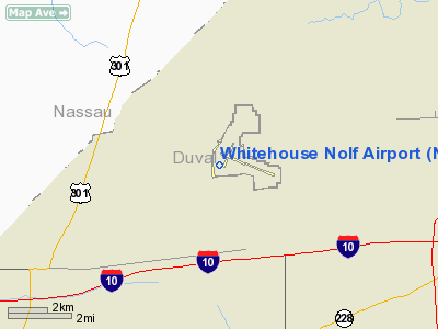
Location
& QuickFacts
|
FAA Information Effective: |
2007-01-18 |
|
Airport
Identifier: |
NEN |
|
Airport
Status: |
Operational |
|
Longitude/Latitude: |
081-52-59.3790W/30-21-00.8570N
-81.883161/30.350238 (Estimated) |
|
Elevation: |
99
ft / 30.18 m (Estimated) |
|
Land: |
0
acres |
|
From
nearest city: |
0 nautical miles of Jacksonville, FL |
|
Location: |
Duval County, FL |
|
Magnetic Variation: |
03W (1985) |
Owner
& Manager
|
Ownership: |
Navy owned |
|
Owner: |
Us Navy |
|
Address: |
Oceanographic Ofc - Code 3142
Washington, DC 20373 |
|
Address: |
|
Airport
Operations and Facilities
|
Airport Use: |
Private |
|
Segmented
Circle: |
No |
|
Control
Tower: |
Yes |
|
Lighting
Schedule: |
PRIOR REQ
ROTG BCN SCHEDULE AS REQUIRED BY MIL OPNL REQUIREMENTS. |
|
Beacon
Color: |
Clear-Green (lighted land airport) |
|
Sectional
chart: |
Jacksonville |
|
Region: |
ASO - Southern |
|
Boundary
ARTCC: |
ZJX - Jacksonville |
|
Tie-in
FSS: |
GNV - Gainesville |
|
FSS
on Airport: |
No |
|
FSS
Phone: |
850-377-3291 |
|
FSS
Toll Free: |
1-800-WX-BRIEF |
|
Runway Information
Runway 11/29
|
Dimension: |
8000 x 150 ft / 2438.4 x 45.7 m |
|
Surface: |
ASPH, |
|
Weight
Limit: |
Dual tandem wheel: 315000 lbs. |
|
Edge
Lights: |
Low |
|
|
Runway 11 |
Runway 29 |
|
Traffic
Pattern: |
Left |
Right |
|
Radio Navigation
Aids
|
ID |
Type |
Name |
Ch |
Freq |
Var |
Dist |
|
HEG |
NDB |
Herlong |
|
332.00 |
02W |
5.9 nm |
|
JA |
NDB |
Dinns |
|
344.00 |
03W |
8.1 nm |
|
EYA |
NDB |
Eastport |
|
357.00 |
03W |
14.9 nm |
|
LCQ |
NDB |
Lake City |
|
204.00 |
03W |
37.4 nm |
|
IAK |
NDB |
Palatka |
|
243.00 |
05W |
42.1 nm |
|
GN |
NDB |
Wynds |
|
269.00 |
04W |
43.6 nm |
|
NZC |
TACAN |
Cecil/dcmsnd |
088X |
|
04W |
7.8 nm |
|
NIP |
TACAN |
Jacksonville |
19X |
|
04W |
12.8 nm |
|
NRB |
TACAN |
Mayport |
051X |
|
03W |
24.0 nm |
|
VQQ |
VOR |
Cecil |
|
117.90 |
03W |
8.3 nm |
|
SGJ |
VOR/DME |
St Augustine |
031X |
109.40 |
06W |
37.2 nm |
|
CRG |
VORTAC |
Craig |
092X |
114.50 |
03W |
19.4 nm |
|
TAY |
VORTAC |
Taylor |
076X |
112.90 |
03W |
35.9 nm |
|
GNV |
VORTAC |
Gators |
109X |
116.20 |
04W |
44.5 nm |
|
SSI |
VORTAC |
Brunswick |
035X |
109.80 |
04W |
47.8 nm |
|
JAX |
VOT |
Jacksonville Intl |
|
111.00 |
|
13.2 nm |
Remarks
- (E137-1)
FCLP HAS PRIORITY. CARRIER DECK MRKGS ON APCH END BOTH RWYS.
NO FULL STOP
LNDG.
Whitehouse Nolf Airport
Address:
Duval County, FL
Tel:
Images
and information placed above are from
http://www.airport-data.com/airport/NEN/
We
thank them for the data!
| General
Info |
| Country |
United
States |
| State |
FLORIDA
|
| FAA ID |
NEN
|
| Latitude |
30-21-00.857N
|
| Longitude |
081-52-59.379W
|
| Elevation |
99 feet
|
| Near City |
JACKSONVILLE
|
We don't guarantee the information is fresh and accurate. The data may
be wrong or outdated.
For more up-to-date information please refer to other sources.
|
|


